


|
시장보고서
상품코드
1528165
방위용 관성 항법 시스템 시장(2024-2034년)Global Defense Inertial Navigation System Market 2024-2034 |
||||||
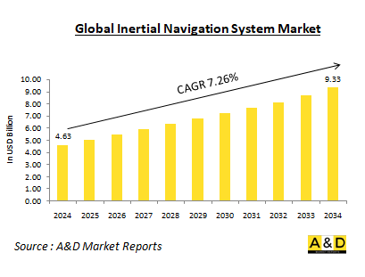
세계의 관성 항법 시스템 시장은 2024년에 46억 3,000만 달러로 추정되고, 예측기간 중(2024-2034년) 7.26%의 연평균 성장률(CAGR)로 확대될 전망이며, 2034년까지 93억 3,000만 달러로 성장할 것으로 예측됩니다.
방위용 관성 항법 시스템 시장 개요
관성 항법 시스템(INS)은 가속도계와 자이로스코프를 사용하여 가속도와 각속도를 측정하는 자동화된 항법 시스템입니다. 이러한 측정값을 시간에 따라 통합함으로써 GPS와 같은 외부 기준에 의존하지 않고 이동체의 위치, 방향, 속도를 결정할 수 있습니다. INS는 이러한 독립성으로 인해 GPS 신호가 방해되거나 스푸핑될 수 있는 군사 용도에 매우 중요합니다. 방위 분야에서 INS는 항공기, 선박, 잠수함, 미사일, 지상 차량 등 폭넓은 플랫폼에서 채용되고 있습니다. INS는 정확한 항행, 유도, 제어 시스템의 기반을 제공합니다.
방위용 관성 항법 시스템 시장에서의 기술의 영향
기술 진보로 관성 항법 시스템(INS)의 능력이 크게 향상되었습니다. 주된 발전의 하나는 소형화로, 최신의 INS 컴퍼넌트는 소형화 및 경량화되어, 드론이나 미사일 등의 소형 플랫폼에의 통합이 가능하게 되었습니다. 이 소형화에 의해 INS 기술의 응용 범위가 넓어졌습니다. 게다가 위치, 속도 및 자세의 결정 정밀도를 높이는 센서나 알고리즘의 개선에 의해 정밀도가 현저하게 향상하고 있습니다. 또 다른 중요한 발전은 센서 퓨전으로, INS 데이터를 GPS 및 지자기 센서와 같은 다른 센서의 입력과 결합하는 것입니다. 이 통합은 전체 시스템의 정확성과 신뢰성을 향상시키고 보다 강력한 항법 솔루션을 제공합니다. 또한 MEMS 기술의 사용도 중요한 역할을 하고, INS 컴포넌트의 비용을 절감하고, 다양한 용도에 이용하기 쉬워졌습니다. 마지막으로, 광섬유 자이로스코프(FOG)는 기존의 기계식 자이로스코프를 대체하는 탁월한 옵션으로 등장하여 정확성과 신뢰성 측면에서 향상된 성능을 제공합니다. 이러한 기술 진보는 종합적으로 INS 능력의 상당한 향상에 기여합니다.
방위용 관성 항법 시스템 시장의 주요 촉진요인
국방 분야에서 관성 항법 시스템(INS)의 개발과 채택을 뒷받침하는 몇 가지 요인이 있습니다. 주요 요인 중 하나는 GPS 취약점입니다. GPS 방해와 스푸핑 위협이 증가함에 따라 GPS 신호가 침해된 경우에도 안정적인 유도 기능을 제공할 수 있는 INS와 같은 독립적인 항법 시스템의 필요성이 강조되고 있습니다. 또 다른 중요한 요인은 정밀 타격 능력 수요입니다. 정확한 무기의 운반은 정확한 네비게이션에 의존하기 때문에 INS는 탄약이 의도한 타겟에 높은 정밀도로 명중하는 것을 보장하는데 있어서 매우 중요한 요소가 되고 있습니다. 자율 시스템의 대두도 INS의 채용을 뒷받침하고 있습니다. 무인 차량과 자율 플랫폼이 효과적으로 작동하려면 견고한 네비게이션 솔루션이 필요하며 INS는 기능과 신뢰성을 실현하는 중요한 요소입니다. 수중 작전 지역에서는 수중 환경에서 GPS 신호가 없기 때문에 잠수함과 기타 수중 차량은 INS에 크게 의존합니다. INS는 이러한 임무를 지원하는 데 필요한 항해 데이터를 제공합니다. 마지막으로 비용 절감이 중요한 역할을 합니다. 기술의 진보로 INS는 보다 저렴한 가격이 되어, 다양한 방어 시스템이나 플랫폼에의 응용이 확산되고 있습니다.
방위용 관성 항법 시스템 시장의 지역별 동향
관성 항법 시스템(INS)의 개발과 채용에 있어서의 지역 동향은 방위 예산, 기술력, 지정학적 우선 순위 등 다양한 요인에 의해 형성됩니다. 방위기술의 세계적 리더인 미국에서는 INS의 연구개발에 상당한 투자가 이루어지고 있습니다. 그 초점은 전략 및 전술 용도 모두에서 INS 시스템의 진보입니다. 미국은 군사적 우위를 유지하고 다양한 플랫폼에서 작전 효과를 높이기 위해 최첨단 기술을 우선하고 있습니다. 유럽 국가들은 특히 갈릴레오 위성 항법 시스템과 같은 노력을 통해 INS 개발에 적극적으로 협력하고 있습니다. INS의 진보를 보다 광범위한 용도와 통합하고, 방위와 민생 모두의 요구를 서포트하는 것을 목적으로 한, 민생 및 군사의 듀얼 유스 기술에 강한 중점을 두고 있습니다. INS 개발의 오랜 역사를 가진 러시아는 탄도 미사일과 잠수함 등 군사 용도를 중심으로 이 기술에 많은 투자를 계속하고 있습니다. 이 나라의 이니셔티브는 자국의 전략 능력을 강화하고 방어 시스템의 신뢰성을 확보하기 위해 노력하고 있습니다. 중국은 성장하는 방위 산업과 연구 개발에 많은 투자를 함으로써 INS 능력을 급속히 향상시키고 있습니다. 그 목표는 외국 기술에 대한 의존을 줄이고 확대하는 군사적 및 전략적 이익을 지원하는 국내 능력을 강화하는 것입니다. 높은 기술력으로 유명한 이스라엘은 방위용과 상업용으로 첨단 INS 시스템을 개발해 왔습니다. 이스라엘은 전문 지식을 활용하여 다양한 요구에 부응하는 정교한 네비게이션 솔루션을 생산하고 있으며, 이는 세계의 기술 상황에서 이스라엘의 확고한 지위를 반영합니다.
방위용 관성 항법 시스템의 주요 프로그램
Exail은 Rheinmetall에서 독일 육군 Caracal 4x4 차량용 Advans Ursa 관성 항법 시스템(INS)을 1,004대 납품하는 중요한 계약을 획득했습니다. 이 계약은 Rheinmetall이 독일과 네덜란드 군에 3,000대 이상의 Caracal Airmobile 플랫폼을 공급한다는 최근의 대규모 계약에 이어집니다.
미네아폴리스에 위치한 Honeywell International Inc.는 AN/WSN-7 전투 시스템을 지원하는 관성 항법 링 레이저 자이로 유닛공급과 관련하여 약 1,204만 5,229달러의 고정 가격 요구 계약을 획득했습니다. 계약 기간은 1년이며 추가 옵션이 없으며 2024년 4월까지 Mineapolis에서 모든 작업을 완료해야 합니다. 계약 총액 1,204만 5,229달러는 계약 체결 시 연간 운전 자금(해군)을 통해 조달되며, 이러한 자금은 당 회계 연도 이후에도 이용 가능합니다. 이 계약은 미국 코드 3204(a)(1)의 권한에 따라 단독 조달 요건으로 발행되었으며, 1개 회사가 모집되었으며 1개사가 쿠폰을 받았습니다. 펜실베니아 주 Mechanicsvurg에 본사를 둔 해군 공급 시스템 사령부 무기 시스템 지원이 계약 활동을 감독하고 있습니다(N00104-23-D-GT01). 수주일은 2023년 5월 23일입니다.
Thales는 Embraer Defence and Security에서 KC-390 군용 수송기용 관성 항법 시스템(INS)과 GPS를 공급하는 계약을 수주했습니다. Thales의 고성능 관성 참조 시스템(HPIRS)은 관성 항법의 획기적인 개발이며 군용기에 필요한 성능 수준을 갖춘 인증 민간 제품의 이점을 제공합니다. 이 혁신적인 시스템은 뛰어난 항법 능력을 제공하여 군용기가 모든 기상 조건 하에서 최대한의 안전을 보장하면서 임무를 수행할 수 있습니다. 또한, 항공기의 네비게이션 시스템은 라이프사이클과 정비 비용을 대폭 절감할 수 있는 독자적인 아키텍처를 특징으로 하며, 폭넓은 민간기나 군용기에 설치하기에 적합합니다.
목차
방위용 관성 항법 시스템 시장 : 보고서 정의
방위용 관성 항법 시스템 시장 내역
- 플랫폼별
- 지역별
- 최종 사용자별
방위용 관성 항법 시스템 시장 분석(향후 10년간)
방위용 관성 항법 시스템 시장 시장 기술
세계의 방위용 관성 항법 시스템 시장 예측
방위용 관성 항법 시스템 시장 : 지역별 동향 및 예측
- 북미
- 촉진 및 억제요인, 과제
- PEST 분석
- 시장 예측 및 시나리오 분석
- 주요 기업
- 공급자 계층의 상황
- 기업 벤치마킹
- 유럽
- 중동
- 아시아태평양
- 남미
방위용 관성 항법 시스템 시장 : 국가별 분석
- 미국
- 방위 계획
- 최신 동향
- 특허
- 이 시장의 현재 기술 성숙 수준
- 시장 예측 및 시나리오 분석
- 캐나다
- 이탈리아
- 프랑스
- 독일
- 네덜란드
- 벨기에
- 스페인
- 스웨덴
- 그리스
- 호주
- 남아프리카
- 인도
- 중국
- 러시아
- 한국
- 일본
- 말레이시아
- 싱가포르
- 브라질
방위용 관성 항법 시스템 시장 : 시장 기회 매트릭스
방위용 관성 항법 시스템 시장 : 조사에 관한 전문가의 견해
결론
Aviation and Defense Market Reports 정보
AJY 24.08.19The Global Inertial Navigation System Market is estimated at USD 4.63 billion in 2024, projected to grow to USD 9.33 billion by 2034 at a Compound Annual Growth Rate (CAGR) of 7.26% over the forecast period 2024-2034
Introduction to Defense Inertial Navigation Systems Market:
An Inertial Navigation System (INS) is a self-contained navigation system that uses accelerometers and gyroscopes to measure acceleration and angular rate. By integrating these measurements over time, the system can determine the position, orientation, and velocity of a moving object without relying on external references like GPS. This independence makes INS crucial for military applications, where GPS signals can be jammed or spoofed. In the defense sector, INS is employed across a wide range of platforms, including aircraft, ships, submarines, missiles, and ground vehicles. It provides the foundation for accurate navigation, guidance, and control systems.
Technology Impact in Defense Inertial Navigation Systems Market:
Advancements in technology have significantly enhanced the capabilities of Inertial Navigation Systems (INS). One key development is miniaturization, which has made modern INS components smaller and lighter, allowing for their integration into compact platforms such as drones and missiles. This reduction in size has expanded the range of applications for INS technology. Additionally, there has been a notable increase in accuracy, driven by improvements in sensors and algorithms that enhance the precision of position, velocity, and attitude determinations. Another important advancement is sensor fusion, which involves combining INS data with inputs from other sensors like GPS and magnetometers. This integration improves the overall accuracy and reliability of the system, providing more robust navigational solutions. The use of Micro electromechanical Systems (MEMS) technology has also played a crucial role, reducing the cost of INS components and making them more accessible for a variety of applications. Finally, Fiber Optic Gyroscopes (FOGs) have emerged as a superior alternative to traditional mechanical gyroscopes, offering enhanced performance in terms of accuracy and reliability. These technological advancements collectively contribute to the significant enhancement of INS capabilities.
Key Drivers in Defense Inertial Navigation Systems Market:
Several factors are driving the development and adoption of Inertial Navigation Systems (INS) in the defense sector. One major factor is GPS vulnerability. The increasing threat of GPS jamming and spoofing underscores the need for independent navigation systems like INS, which can provide reliable guidance even when GPS signals are compromised. Another key driver is the demand for precision strike capabilities. Accurate weapon delivery relies on precise navigation, making INS a crucial component in ensuring that munitions hit their intended targets with high precision. The rise of autonomous systems also fuels the adoption of INS. Unmanned vehicles and autonomous platforms require robust navigation solutions to operate effectively, and INS is a key enabler of their functionality and reliability. In the realm of underwater operations, submarines and other underwater vehicles depend heavily on INS due to the absence of GPS signals in submerged environments. INS provides the necessary navigation data to support these missions. Finally, cost reduction plays a significant role. Advances in technology have made INS more affordable, broadening its applications across various defense systems and platforms.
Regional Trends in Defense Inertial Navigation Systems Market:
Regional trends in the development and adoption of Inertial Navigation Systems (INS) are shaped by various factors, including defense budgets, technological capabilities, and geopolitical priorities. In the United States, which is a global leader in defense technology, significant investments have been made in INS research and development. The focus is on advancing INS systems for both strategic and tactical applications. The US prioritizes cutting-edge technologies to maintain its military edge and enhance operational effectiveness across various platforms. European countries are actively collaborating on INS development, particularly through initiatives like the Galileo satellite navigation system. There is a strong emphasis on civil-military dual-use technologies, which aim to integrate advancements in INS with broader applications, supporting both defense and civilian needs. Russia, with its long history of INS development, continues to invest heavily in this technology, focusing on military applications such as ballistic missiles and submarines. The country's efforts are geared towards enhancing its strategic capabilities and ensuring the reliability of its defense systems. China is making rapid advancements in its INS capabilities, driven by a growing defense industry and substantial investments in research and development. The goal is to reduce reliance on foreign technology and enhance domestic capabilities to support its expanding military and strategic interests. Israel, known for its technological prowess, has developed advanced INS systems for both defense and commercial applications. The country leverages its expertise to produce sophisticated navigation solutions that cater to a variety of needs, reflecting its strong position in the global technology landscape.
Key Defense Inertial Navigation Systems Program:
Exail has won a significant contract with Rheinmetall to deliver 1,004 units of its Advans Ursa inertial navigation systems (INS) for the German Army's Caracal 4x4 vehicles. This deal follows Rheinmetall's recent, more extensive contract to supply over 3,000 Caracal airmobile platforms to the armed forces of Germany and the Netherlands.
Honeywell International Inc., located in Minneapolis, has been awarded a firm-fixed-price requirements contract valued at approximately $12,045,229 for the supply of Inertial Navigation Ring Laser Gyro units supporting the AN/WSN-7 Combat System. The contract spans one year with no additional options and requires all work to be completed in Minneapolis by April 2024. The total contract amount of $12,045,229 will be funded through annual working capital funds (Navy) at the time of the award, and these funds will remain available beyond the current fiscal year. The contract was issued as a sole-source requirement under authority 10 U.S. Code 3204 (a)(1), with one company solicited and one offer received. Naval Supply Systems Command Weapon Systems Support, based in Mechanicsburg, Pennsylvania, is overseeing the contracting activity (N00104-23-D-GT01). The award was made on May 23, 2023.
Thales has been awarded a contract by Embraer Defence and Security to supply the Inertial Navigation System (INS) and GPS for the KC-390 military transport aircraft. Thales's High Performance Inertial Reference System (HPIRS) is a groundbreaking development in inertial navigation, offering the benefits of a certified civilian product with the performance levels required by military aircraft. This innovative system provides exceptional navigational capabilities, enabling military aircraft to perform missions in all weather conditions with the utmost safety. Additionally, the aircraft's navigation system features a unique architecture that significantly reduces life cycle and maintenance costs, making it suitable for installation on a wide range of civil and military aircraft.
Table of Contents
Defense Intertial Navigation System Market Report Definition
Defense Intertial Navigation System Market Segmentation
By Platform
By Region
By End User
Defense Intertial Navigation System Market Analysis for next 10 Years
The 10-year Defense Intertial Navigation System Market analysis would give a detailed overview of Defense Intertial Navigation System Market growth, changing dynamics, technology adoption overviews and the overall market attractiveness is covered in this chapter.
Market Technologies of Defense Intertial Navigation System Market
This segment covers the top 10 technologies that is expected to impact this market and the possible implications these technologies would have on the overall market.
Global Defense Intertial Navigation System Market Forecast
The 10-year defense intertial navigation system market forecast of this market is covered in detailed across the segments which are mentioned above.
Regional Defense Intertial Navigation System Market Trends & Forecast
The regional defense intertial navigation system market trends, drivers, restraints and Challenges of this market, the Political, Economic, Social and Technology aspects are covered in this segment. The market forecast and scenario analysis across regions are also covered in detailed in this segment. The last part of the regional analysis includes profiling of the key companies, supplier landscape and company benchmarking. The current market size is estimated based on the normal scenario.
North America
Drivers, Restraints and Challenges
PEST
Market Forecast & Scenario Analysis
Key Companies
Supplier Tier Landscape
Company Benchmarking
Europe
Middle East
APAC
South America
Country Analysis of Defense Intertial Navigation System Market
This chapter deals with the key defense programs in this market, it also covers the latest news and patents which have been filed in this market. Country level 10 year market forecast and scenario analysis are also covered in this chapter.
US
Defense Programs
Latest News
Patents
Current levels of technology maturation in this market
Market Forecast & Scenario Analysis
Canada
Italy
France
Germany
Netherlands
Belgium
Spain
Sweden
Greece
Australia
South Africa
India
China
Russia
South Korea
Japan
Malaysia
Singapore
Brazil
Opportunity Matrix for Defense Intertial Navigation System Market
The opportunity matrix helps the readers understand the high opportunity segments in this market.
Expert Opinions on Defense Intertial Navigation System Market Report
Hear from our experts their opinion of the possible analysis for this market.
Conclusions
About Aviation and Defense Market Reports
