
|
시장보고서
상품코드
1546379
Airborne LIDAR 시장(2024-2034년)Global Airborne LIDAR Market 2024-2034 |
||||||
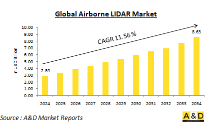
세계 Airborne LIDAR 시장은 2024년 28억 9,000만 달러로 추정되며, 2024년부터 2034년까지 예측 기간 동안 11.56%의 연평균 성장률(CAGR)로 확대되어 2034년까지 86억 3,000만 달러로 성장할 것으로 예상됩니다.
세계 Airborne LiDAR 시장 개요
Airborne LIDAR 시스템은 지형 매핑, 임업 관리, 도시 계획, 재난 관리, 환경 모니터링 등 다양한 분야에서 활용되고 있습니다. 이 기술은 디지털 고도 모델 생성, 식생 높이 평가, 인프라 매핑에 사용할 수 있는 고정밀 데이터를 제공합니다. Airborne LIDAR의 범용성과 정확성은 항공우주, 국방, 농업, 토목 공학 및 기타 산업에서 귀중한 도구로 활용되고 있습니다. 상세한 지리적 데이터에 대한 수요 증가와 다양한 분야에서 LiDAR 기술 채택이 확대되면서 시장 확대에 기여하고 있습니다. 도시화가 가속화되고 환경에 대한 관심이 높아지면서 정확한 매핑 및 모니터링 솔루션에 대한 수요가 증가하고 있습니다. 또한, 드론 기술의 발전으로 인해 Airborne LIDAR 시스템이 더욱 친숙하고 비용 효율적이 되어 시장 성장을 더욱 촉진하고 있습니다. 또한, LiDAR와 지리정보시스템(GIS)의 통합은 그 유용성을 높여 사용자가 데이터를 보다 효과적으로 분석 및 시각화할 수 있도록 돕고 있습니다.
세계 Airborne LIDAR 시장에서 기술의 영향력
기술의 발전은 Airborne LIDAR 시장에 큰 영향을 미치고 있으며, 이 기술의 능력과 활용도를 향상시키고 있습니다. 가이거 모드 LiDAR 및 단일 광자 LiDAR를 포함한 보다 정교한 레이저 시스템의 개발로 데이터 수집의 해상도와 정확도가 향상되었습니다. 이러한 발전은 기존 측량 방법으로는 어려운 밀림이나 도시 지역과 같은 복잡한 환경에서도 보다 상세한 정보를 얻을 수 있게 해주었으며, LiDAR와 무인항공기(UAV)의 통합은 비용 효율적이고 효율적인 데이터 수집을 광범위하게 가능하게 하여 시장에 혁명을 일으켰습니다. LiDAR 센서가 장착된 UAV는 접근하기 어려운 곳에 접근이 가능하여 재난 대응, 환경 모니터링, 인프라 검사 등의 용도에 적합합니다. UAV 기반 LiDAR 시스템은 고해상도 데이터를 빠르고 안전하게 수집할 수 있기 때문에 다양한 산업 분야에서 인기를 끌고 있습니다. 또한, 데이터 처리 소프트웨어의 발전으로 Airborne LIDAR 프로젝트와 관련된 워크플로우가 간소화되었습니다. 최신 소프트웨어 솔루션은 대규모 데이터 세트를 효율적으로 처리할 수 있어 LiDAR 데이터를 신속하게 처리하고 분석할 수 있습니다. 이 기능은 도시 계획가나 응급 구조대원 등 의사결정을 위해 적시에 정보를 필요로 하는 업계에서 매우 중요하며, LiDAR 데이터를 항공 영상과 같은 다른 지형 공간 정보와 결합하면 데이터 세트가 더욱 풍부해져 보다 종합적인 통찰력을 얻을 수 있습니다.
세계 Airborne LIDAR 시장의 주요 촉진요인
몇 가지 주요 촉진요인이 Airborne LIDAR 시장의 성장을 가속하고 있습니다. 주요 요인 중 하나는 도시 계획, 임업, 환경 관리 등 다양한 분야에서 고해상도 매핑에 대한 수요가 증가하고 있다는 점입니다. Airborne LIDAR 시스템은 기존 측량 방법으로는 대응할 수 없는 세부 사항과 정확도를 제공하여 정확한 지리 데이터를 생성하는 데 필수적인 도구가 되고 있습니다. 이러한 상세한 매핑에 대한 수요 증가는 Airborne LIDAR 기술의 채택을 크게 촉진하고 있습니다. 기술 발전 또한 시장을 주도하는 데 중요한 역할을 하고 있습니다. 레이저 시스템 강화, 무인항공기(UAV)와의 통합, 데이터 처리 능력 향상 등 LiDAR 기술의 끊임없는 혁신이 시장 성장에 기여하고 있습니다. 이러한 발전은 Airborne LIDAR 시스템의 성능과 기능을 향상시킬 뿐만 아니라, 보다 많은 사용자들이 보다 쉽게 사용할 수 있고 매력적으로 다가갈 수 있도록 돕고 있습니다. 기술의 발전과 함께 Airborne LIDAR의 능력과 용도는 계속 확장되고 있습니다. 항공우주 및 국방 분야에서의 Airborne LIDAR 채택 확대도 중요한 원동력이 되고 있습니다. 이들 산업은 감시, 정찰, 지형 매핑 등의 분야에서 LiDAR 기술에 대한 의존도가 높아지고 있습니다. 강력한 감시 시스템과 정확한 지형 공간 데이터에 대한 수요로 인해 이들 분야에서 LiDAR 기술에 대한 대규모 투자가 이루어지고 있으며, 이는 시장 성장을 더욱 촉진하고 있습니다. 환경 모니터링 및 재난 관리도 Airborne LIDAR 시장 확대에 기여하고 있습니다. 자연재해의 빈도가 증가하고 환경 문제에 대한 관심이 높아짐에 따라 효과적인 모니터링 및 평가 도구의 필요성이 증가하고 있습니다. Airborne LIDAR 시스템은 재난 대응에 매우 효과적이며, 피해 지역에 신속한 평가 기능을 제공하고 상세하고 정확한 데이터로 복구 작업을 지원합니다. 또한, 도시화와 인프라 개발은 Airborne LIDAR에 대한 수요를 촉진하고 있습니다. 도시가 성장하고 인프라 프로젝트가 증가함에 따라 정확한 매핑 및 계획 도구의 필요성이 증가하고 있습니다. Airborne LIDAR는 인프라 프로젝트를 효과적으로 계획, 관리 및 실행하는 데 필요한 데이터를 제공함으로써 도시 개발 이니셔티브를 지원하는 데 중요한 역할을 하고 있습니다. 고해상도의 상세한 지도를 제공하는 이 기술의 능력은 효율적인 도시 계획과 개발을 지원하며, 그 보급을 더욱 가속화할 것입니다.
세계 Airborne LIDAR 시장의 지역별 동향
Airborne LIDAR 시장은 기술 도입, 산업 수요, 정부 이니셔티브 등 다양한 요인의 영향을 받아 지역별로 뚜렷한 추세를 보이고 있습니다. 북미는 주요 기업의 존재와 기술에 대한 실질적인 투자가 주요 요인으로 작용하여 가장 큰 시장을 형성하고 있습니다. 특히 미국은 LiDAR를 다양한 용도로 폭넓게 활용하고 있는 항공우주 및 방위 분야의 견조한 성장세가 두드러집니다. 또한, 상업용 무인항공기(UAV)의 채택이 증가하면서 이 지역 시장 성장에 더욱 기여하고 있으며, Airborne LIDAR 기술에서 북미의 리더십을 더욱 부각시키고 있습니다. 유럽은 환경 모니터링과 도시 계획에 중점을 두고 있는 것이 시장 특징입니다. 독일, 영국, 프랑스와 같은 국가들은 인프라 개발을 지원하고 종합적인 환경 평가를 수행하기 위해 Airborne LIDAR 기술에 많은 투자를 하고 있습니다. 지형 공간 데이터 수집을 강화하기 위한 유럽 국가들 간의 협력적 노력도 시장을 견인하고 있으며, 이는 LiDAR 기술을 활용하여 지역 전체의 계획과 관리를 개선하려는 공동의 노력을 반영하고 있습니다. 아시아태평양은 급속한 도시화와 인프라 프로젝트에 대한 투자 증가로 인해 Airborne LIDAR 시장이 크게 성장할 것으로 예상됩니다. 중국, 인도, 일본과 같은 국가들은 도시 계획에서 재난 관리까지 다양한 용도로 LiDAR 기술을 채택하고 있습니다. 이들 국가는 스마트 시티에 대한 관심이 높아지면서 고해상도 매핑 솔루션에 대한 수요가 더욱 증가하고 있습니다. 중동 및 아프리카의 Airborne LIDAR 시장은 인프라 구축과 환경 모니터링의 필요성에 의해 형성되고 있습니다. 이 지역 국가들은 석유 및 가스 탐사, 도시 계획, 천연자원 관리 등에 LiDAR 기술을 활용하고 있습니다. 인프라 구축과 천연자원 관리에 중점을 두고 있는 이 지역의 발전된 니즈와 우선순위를 반영하여 Airborne LIDAR의 채택을 촉진하고 있습니다. 라틴아메리카의 경우, 다른 지역에 비해 상대적으로 작은 시장이지만, 다양한 분야에서 이 기술의 이점을 인식하고 있습니다. 브라질과 아르헨티나와 같은 국가들은 환경 모니터링 및 도시 개발을 위한 LiDAR 용도를 모색하기 시작했습니다. Airborne LIDAR 기술에 대한 이러한 새로운 관심은 이들 국가들이 개발 및 환경 관리 노력을 지원하기 위해 첨단 매핑 솔루션을 활용하려는 노력으로 인해 향후 성장 가능성을 보여주고 있습니다.
Airborne LIDAR의 주요 프로그램
아레테(Arete)는 수중 지뢰, 위험물, 목표물을 자동으로 탐지할 수 있는 무인항공기용 LiDAR 센서를 개발할 계획입니다. 미 해군 연구원들은 소형 전술 무인항공기(UAV)의 기뢰 탐지, 무인수상정(UUV) 탐지 및 기타 목표물 식별 작업의 능력을 강화하기 위해 실험용 에어본 센서가 필요했습니다. 그들은 캘리포니아 주 노스 리지에 위치한 Arete Associates에서 필요한 솔루션을 발견했습니다.
공군의 엔터프라이즈 시설 계약을 통해 수집된 에어본 이미지와 LiDAR 데이터는 허리케인이 강타한 플로리다의 팅달 공군기지를 포함한 미래 시설의 디지털 인프라를 강화 및 보강하고 있습니다. 이러한 데이터 소스의 높은 충실도와 정확도는 향후 시설 내 자율 주행 차량의 배치와 미래의 스마트 시설로 나아가기 위한 센서의 전략적 배치에 필수적입니다.
목차
Airborne LIDAR 시장 : 보고서 정의
Airborne LIDAR 시장 내역
- 지역별
- 최종사용자별
- 용도별
Airborne LIDAR 시장 분석(향후 10년간)
Airborne LIDAR 시장 기술
세계의 Airborne LIDAR 시장 예측
Airborne LIDAR 시장 : 지역별 동향과 예측
- 북미
- 시장 성장 촉진요인 및 억제요인, 과제
- PEST 분석
- 시장 예측과 시나리오 분석
- 주요 기업
- 공급업체 계층 상황
- 기업 벤치마킹
- 유럽
- 중동
- 아시아태평양
- 남미
Airborne LIDAR 시장 : 국가별 분석
- 미국
- 방위 계획
- 최신 동향
- 특허
- 현재의 시장 기술 성숙도
- 시장 예측과 시나리오 분석
- 캐나다
- 이탈리아
- 프랑스
- 독일
- 네덜란드
- 벨기에
- 스페인
- 스웨덴
- 그리스
- 호주
- 남아프리카공화국
- 인도
- 중국
- 러시아
- 한국
- 일본
- 말레이시아
- 싱가포르
- 브라질
Airborne LIDAR 시장 : 시장 기회 매트릭스
Airborne LIDAR 시장 : 조사에 관한 전문가의 견해
결론
Aviation and Defense Market Reports에 대해
LSH 24.09.12The Global Airborne LIDAR Market is estimated at USD 2.89 billion in 2024, projected to grow to USD 8.63 billion by 2034 at a Compound Annual Growth Rate (CAGR) of 11.56% over the forecast period 2024-2034
Introduction to the Airborne LiDAR Market:
Airborne LiDAR systems are utilized in a variety of applications, including topographic mapping, forestry management, urban planning, disaster management, and environmental monitoring. The technology provides highly accurate data that can be used for creating digital elevation models, assessing vegetation height, and mapping infrastructure. The versatility and precision of airborne LiDAR make it an invaluable tool for industries such as aerospace, defense, agriculture, and civil engineering. The market's expansion is fueled by the increasing need for detailed geographical data and the growing adoption of LiDAR technology in various sectors. As urbanization accelerates and environmental concerns rise, the demand for accurate mapping and monitoring solutions has become more pronounced. Additionally, advancements in drone technology have made airborne LiDAR systems more accessible and cost-effective, further driving market growth. The integration of LiDAR with Geographic Information Systems (GIS) has also enhanced its utility, enabling users to analyze and visualize data more effectively.
Technology Impact in the Airborne LiDAR Market:
Technological advancements have significantly impacted the airborne LiDAR market, enhancing the capabilities and applications of this technology. The development of more sophisticated laser systems, including Geiger-mode and single-photon LiDAR, has improved the resolution and accuracy of data collection. These advancements allow for the capture of finer details in complex environments, such as dense forests or urban areas, where traditional surveying methods may struggle. The integration of LiDAR with unmanned aerial vehicles (UAVs) has revolutionized the market by enabling cost-effective and efficient data collection over large areas. UAVs equipped with LiDAR sensors can access hard-to-reach locations, making them ideal for applications such as disaster response, environmental monitoring, and infrastructure inspection. The ability to collect high-resolution data quickly and safely has made UAV-based LiDAR systems increasingly popular among various industries. Furthermore, advancements in data processing software have streamlined the workflow associated with airborne LiDAR projects. Modern software solutions can handle large datasets efficiently, allowing for rapid processing and analysis of LiDAR data. This capability is crucial for industries that require timely information for decision-making, such as urban planners and emergency responders. The fusion of LiDAR data with other geospatial information, such as aerial imagery, enhances the richness of the datasets and provides more comprehensive insights.
Key Drivers in the Airborne LiDAR Market:
Several key drivers are propelling the growth of the airborne LiDAR market. One of the primary factors is the increased demand for high-resolution mapping across various sectors such as urban planning, forestry, and environmental management. Airborne LiDAR systems offer a level of detail and accuracy that traditional surveying methods cannot match, making them essential tools for generating precise geographical data. This growing need for detailed mapping is significantly boosting the adoption of airborne LiDAR technology. Technological advancements also play a crucial role in driving the market. Continuous innovations in LiDAR technology, including enhancements in laser systems, integration with unmanned aerial vehicles (UAVs), and improvements in data processing capabilities, are contributing to market growth. These advancements not only enhance the performance and functionality of airborne LiDAR systems but also make them more accessible and appealing to a wider range of users. As technology evolves, the capabilities and applications of airborne LiDAR continue to expand. The growing adoption of airborne LiDAR in the aerospace and defense sectors is another significant driver. These industries increasingly rely on LiDAR technology for applications such as surveillance, reconnaissance, and terrain mapping. The demand for robust surveillance systems and accurate geospatial data is prompting substantial investments in LiDAR technology within these sectors, further fueling market growth. Environmental monitoring and disaster management are also contributing to the expansion of the airborne LiDAR market. The rising frequency of natural disasters and growing environmental concerns have heightened the need for effective monitoring and assessment tools. Airborne LiDAR systems are invaluable for disaster response, providing rapid assessment capabilities for affected areas and supporting recovery efforts with detailed and accurate data. Additionally, urbanization and infrastructure development are driving the demand for airborne LiDAR. As cities grow and infrastructure projects increase, there is a heightened need for accurate mapping and planning tools. Airborne LiDAR plays a critical role in supporting urban development initiatives by providing the necessary data for effective planning, management, and execution of infrastructure projects. The technology's ability to deliver high-resolution, detailed maps supports efficient urban planning and development, further accelerating its adoption.
Regional Trends in the Airborne LiDAR Market:
The airborne LiDAR market exhibits distinct regional trends influenced by various factors, including technological adoption, industry demand, and government initiatives. In North America, the market is the largest, driven primarily by the presence of key industry players and substantial investments in technology. The United States, in particular, stands out with its robust aerospace and defense sector, which extensively utilizes LiDAR for a range of applications. Additionally, the increasing adoption of unmanned aerial vehicles (UAVs) for commercial purposes is further contributing to market growth in this region, highlighting North America's leadership in airborne LiDAR technology. In Europe, the market is characterized by a strong focus on environmental monitoring and urban planning. Countries such as Germany, the UK, and France are making significant investments in airborne LiDAR technology to support infrastructure development and conduct comprehensive environmental assessments. The collaborative initiatives among European nations to enhance geospatial data collection are also boosting the market, reflecting a concerted effort to leverage LiDAR technology for improved planning and management across the region. The Asia-Pacific region is anticipated to experience substantial growth in the airborne LiDAR market, driven by rapid urbanization and increasing investments in infrastructure projects. Nations like China, India, and Japan are adopting LiDAR technology for diverse applications, from urban planning to disaster management. The growing emphasis on smart city initiatives in these countries is further propelling the demand for high-resolution mapping solutions, highlighting the region's expanding role in the global LiDAR market. In the Middle East and Africa, the airborne LiDAR market is shaped by the need for infrastructure development and environmental monitoring. Countries in this region are increasingly utilizing LiDAR technology for applications such as oil and gas exploration, urban planning, and natural resource management. The focus on developing infrastructure and managing natural resources is driving the adoption of airborne LiDAR, reflecting the region's evolving needs and priorities. In Latin America, although the airborne LiDAR market is relatively smaller compared to other regions, there is a growing recognition of the technology's benefits across various sectors. Countries like Brazil and Argentina are beginning to explore LiDAR applications for environmental monitoring and urban development. This emerging interest in airborne LiDAR technology indicates a potential for future growth as these countries seek to leverage advanced mapping solutions to support their development and environmental management efforts.
Key Airborne LiDAR Market Program:
Arete is set to develop a lidar sensor for uncrewed aircraft to automate the detection of underwater mines, hazards, and targets. U.S. Navy researchers required an experimental airborne sensor to enhance the capabilities of small tactical uncrewed aerial vehicles (UAVs) for mine countermeasures, uncrewed underwater vehicle (UUV) detection, and other target identification tasks. They discovered the solution they needed from Arete Associates based in Northridge, Calif.
Airborne imagery and LiDAR data collected through an Air Force enterprise installations contract have been enhancing and strengthening the digital infrastructure for future installations, including hurricane-affected Tyndall Air Force Base in Florida. The high fidelity and accuracy of these data sources are essential for the future deployment of autonomous vehicles on installations and for the strategic placement of sensors that will drive the smart facilities of tomorrow.
Table of Contents
Airborne LIDAR Market Report Definition
Airborne LIDAR Market Segmentation
By Region
By End-User
By Application
Airborne LIDAR Market Analysis for next 10 Years
The 10-year Airborne LIDAR Market analysis would give a detailed overview of Airborne LIDAR Market growth, changing dynamics, technology adoption overviews and the overall market attractiveness is covered in this chapter.
Market Technologies of Airborne LIDAR Market
This segment covers the top 10 technologies that is expected to impact this market and the possible implications these technologies would have on the overall market.
Global Airborne LIDAR Market Forecast
The 10-year Airborne LIDAR Market forecast of this market is covered in detailed across the segments which are mentioned above.
Regional Airborne LIDAR Market Trends & Forecast
The regional Airborne LIDAR Market trends, drivers, restraints and Challenges of this market, the Political, Economic, Social and Technology aspects are covered in this segment. The market forecast and scenario analysis across regions are also covered in detailed in this segment. The last part of the regional analysis includes profiling of the key companies, supplier landscape and company benchmarking. The current market size is estimated based on the normal scenario.
North America
Drivers, Restraints and Challenges
PEST
Market Forecast & Scenario Analysis
Key Companies
Supplier Tier Landscape
Company Benchmarking
Europe
Middle East
APAC
South America
Country Analysis of Airborne LIDAR Market
This chapter deals with the key defense programs in this market, it also covers the latest news and patents which have been filed in this market. Country level 10 year market forecast and scenario analysis are also covered in this chapter.
US
Defense Programs
Latest News
Patents
Current levels of technology maturation in this market
Market Forecast & Scenario Analysis
Canada
Italy
France
Germany
Netherlands
Belgium
Spain
Sweden
Greece
Australia
South Africa
India
China
Russia
South Korea
Japan
Malaysia
Singapore
Brazil
Opportunity Matrix for Airborne LIDAR Market
The opportunity matrix helps the readers understand the high opportunity segments in this market.
Expert Opinions on Airborne LIDAR Market Report
Hear from our experts their opinion of the possible analysis for this market.
Conclusions
About Aviation and Defense Market Reports
