
|
시장보고서
상품코드
1773241
토지 측량 장비 시장 기회, 성장 촉진요인, 산업 동향 분석 및 예측(2025-2034년)Land Survey Equipment Market Opportunity, Growth Drivers, Industry Trend Analysis, and Forecast 2025 - 2034 |
||||||
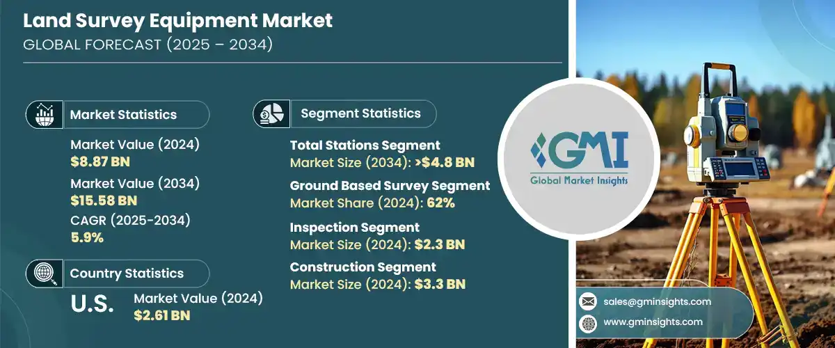
토지 측량 장비 세계 시장 규모는 2024년에 88억 7,000만 달러로 평가되었고, CAGR 5.9%로 성장하여 2034년에는 155억 8,000만 달러에 이를 것으로 예측됩니다.
이러한 시장 확대의 배경에는 농업, 건설, 인프라, 광업 등의 분야에서 정확한 지형공간정보에 대한 요구가 증가하고 있기 때문입니다. 산업계가 효율성, 안전성, 정확성을 최우선시하는 가운데 차세대 측량 기술에 대한 수요가 증가하고 있습니다. 기존의 측량 기술은 GNSS 수신기, 로봇 토탈 스테이션, 3D 레이저 스캐너와 같은 첨단 도구로 빠르게 대체되고 있습니다. 이러한 솔루션을 통해 측량사는 더 빠르고 정확하게 데이터를 수집할 수 있으며, 그 결과 지형도를 개선하고 더 나은 프로젝트를 수행할 수 있게 되었습니다. 측량 기술은 농업의 토지 이용 최적화부터 광업의 작업 안전 개선에 이르기까지 다양한 분야에서 필수적인 역할을 하고 있습니다.
GNSS 수신기, 로봇식 토탈 스테이션, 3D 레이저 스캐너와 같은 첨단 측량 도구는 탁월한 정확도, 더 빠른 데이터 수집, 실시간 분석, 프로젝트 기간 단축, 비용 절감, 오류 제거, 비용 절감, 프로젝트 기간 단축 등의 이점을 제공합니다. 실시간 분석을 제공하고, 프로젝트 타임라인을 단축하고, 비용이 많이 드는 오류를 제거할 수 있도록 도와줍니다. 인프라 개발 및 교통 계획에서 대규모 농업 및 광업에 이르기까지, 고해상도 공간 데이터를 단시간에 획득할 수 있게 되면서 프로젝트 시작, 관리 및 실행 방식에 혁명이 일어나고 있습니다. 건설, 유틸리티, 에너지 등의 분야에서도 워크플로우를 간소화하고, 매핑 및 모델링의 정확도를 높이고, 안전 및 환경 영향에 대한 점점 더 엄격해지는 규제를 준수하기 위해 이러한 기술 혁신에 주목하고 있습니다.
| 시장 범위 | |
|---|---|
| 개시 연도 | 2024년 |
| 예측 연도 | 2025-2034년 |
| 개시 금액 | 88억 7,000만 달러 |
| 예측 금액 | 155억 8,000만 달러 |
| CAGR | 5.9% |
2024년 토탈 스테이션 부문은 34.04%의 점유율을 차지하고 2034년에는 48억 달러에 달했습니다. 각도와 거리를 측정하는 통합 기능으로 고정밀 작업에서 높은 가치를 발휘합니다. 다재다능함과 비용 효율성으로 인해 특히 교통 및 도시 인프라 개발 등 다양한 분야에서 선호되고 있으며, GNSS 호환성, 무선 연결성, 로봇 자동화와 같은 최근의 기술 혁신은 워크플로우를 간소화하고 그 능력을 확장하고 있습니다.
지상 측량 시스템은 2024년 62%의 점유율을 차지했으며, 2025년부터 2034년까지 연평균 복합 성장률(CAGR) 5%를 보일 것으로 예측됩니다. 이 카테고리에는 GNSS 시스템, 수준기, 토탈 스테이션 등 전통적 및 최신 토지 측량 장비가 모두 포함되며, GNSS의 적응성, 신뢰성 및 접근성은 특히 건설 및 도시 계획과 같은 분야에서 광범위한 프로젝트에 적합합니다. 대규모 도시 인프라가 수요를 주도하는 아시아 및 유럽의 고성장 시장에서도 지상 측량은 여전히 필수적입니다.
2024년 미국 토지 측량 장비 시장 점유율은 77.1%로 26억 1,000만 달러에 달했습니다. 북미는 AI 통합 분석, 3D 스캐닝 기술, UAV 기반 측량 도구 등 첨단 토지 측량 시스템 도입에서 세계를 선도하고 있습니다. 미국 시장은 특히 스마트 인프라 및 건설 디지털화 이니셔티브를 통해 디지털화를 빠르게 수용하고 있으며, Hexagon과 Trimble과 같은 기업들은 실시간 고정밀 데이터에 대한 수요 증가에 대응하기 위해 제품 업그레이드, 조사, 측량, 디지털 전환에 지속적으로 투자하고 있습니다. 디지털 전환에 지속적으로 투자함으로써 이 지역의 기술 전망을 형성하는 데 큰 역할을 하고 있습니다.
토지조사기기 산업을 형성하는 주요 기업으로는 GeoTech, Hexagon, Topcon, Trimble, Stonex, DeepWell, FARO, Bosch Tools, Emlid Tech, Shanghai Huace Navigation Technology 등이 있습니다. 토지 조사 장비 시장의 기업들은 진화하는 산업 수요에 부응하는 혁신적이고 다기능의 고정밀 솔루션을 생산하기 위해 연구개발에 많은 투자를 하고 있습니다. 많은 기업들이 AI, IoT, 무선 기술을 측량 장비에 통합하여 자동화, 실시간 데이터 처리, 클라우드 대응을 강화하고 있습니다. 건설 및 인프라 기업과의 파트너십 및 전략적 제휴도 고객 기반 확대의 열쇠를 쥐고 있습니다. 각 업체들은 원격지 및 도시 지역에서의 측량 문제를 해결하기 위해 작고 견고하며 모바일 친화적인 장비 개발에 주력하고 있습니다. 또한, 각 회사는 장비의 지속가능성과 장기적인 유지보수성을 중시하면서 현지 시장에 더 잘 대응할 수 있도록 생산 및 지원 서비스를 현지화하고 있습니다.
목차
제1장 조사 방법과 범위
제2장 주요 요약
제3장 업계 인사이트
- 생태계 분석
- 공급업체 상황
- 전자부품 공급업체
- 기기 제조업체
- 서비스 제공업체
- 시스템 통합사업자
- 최종 용도
- 비용 구조
- 이익률
- 각 단계에서의 부가가치
- 공급망에 영향을 미치는 요인
- 파괴자
- 공급업체 상황
- 영향요인
- 성장 촉진요인
- 업계의 잠재적 리스크&과제
- 시장 기회
- 성장 가능성 분석
- Porter's Five Forces 분석
- PESTEL 분석
- 기술 및 혁신 상황
- 현재 기술
- 고정도 RTK 및 PPK GNSS/GPS 시스템
- 로봇식 및 전동식 토탈 스테이션
- 3D 레이저 스캐너 지상 및 모바일 LiDAR
- 사진 측량과 LiDAR 매핑 드론/UAV
- 신기술
- 데이터 처리를 위한 AI와 머신러닝
- 자율 측량 로봇
- 현장 시각화를 위한 증강현실(AR)
- 안전한 지형공간 데이터 관리를 위한 블록체인
- 현재 기술
- 특허 분석
- 규제 상황
- 북미
- 유럽
- 아시아태평양
- 라틴아메리카
- 중동 및 아프리카
- 생산 통계
- 생산 거점
- 소비 거점
- 수출과 수입
- 비용 내역 분석
- 지속가능성 분석
- 지속가능한 관행
- 폐기물 감축 전략
- 생산 에너지 효율
- 친환경 대처
- 탄소발자국 고려
제4장 경쟁 구도
- 서론
- 기업의 시장 점유율 분석
- 북미
- 유럽
- 아시아태평양
- 라틴아메리카
- 중동 및 아프리카
- 경쟁 포지셔닝 매트릭스
- 전략적 전망 매트릭스
- 주요 발전
- 인수합병(M&A)
- 파트너십 및 협업
- 신제품 발매
- 확장 계획과 자금조달
제5장 시장 추산·예측 : 제품별, 2021년-2034년
- 주요 동향
- 토탈 스테이션
- GPS/GNSS 시스템
- 레이저 스캐너
- 레벨
- 무인항공기(UAV)/드론
- 기타
제6장 시장 추산·예측 : 조사 방법별, 2021년-2034년
- 주요 동향
- 지상 조사
- 레이저 조사
제7장 시장 추산·예측 : 용도별, 2021년-2034년
- 주요 동향
- 검사
- 품질관리 검사
- 구조 검사
- 인프라 검사
- 감시
- 환경 모니터링
- 토지 이용 모니터링
- 측지 모니터링
- 지도제작
- 엔지니어링 및 설계
- 체적 계산
- 토공 계산
- 비축량 계산
- 절토량 및 성토량 계산
- 레이아웃 포인트
- 건설 현장 레이아웃
- 파이프라인 및 유틸리티 조사
- 도로 및 고속도로 레이아웃
- 지역 정보 시스템(GIS)
- 토지 개발 계획
- 농업 측량
- 기타
제8장 시장 추산·예측 : 최종 용도별, 2021년-2034년
- 주요 동향
- 건설
- 석유 및 가스
- 광업
- 유틸리티
- 농업
- 방위 및 보안
- 기타
제9장 시장 추산·예측 : 지역별, 2021년-2034년
- 북미
- 미국
- 캐나다
- 유럽
- 영국
- 독일
- 프랑스
- 이탈리아
- 스페인
- 러시아
- 북유럽 국가
- 아시아태평양
- 중국
- 인도
- 일본
- 한국
- 호주
- 동남아시아
- 라틴아메리카
- 브라질
- 멕시코
- 아르헨티나
- 칠레
- 중동 및 아프리카
- 남아프리카공화국
- 사우디아라비아
- 아랍에미리트(UAE)
제10장 기업 개요
- Aptella
- Baseline Equipment Company
- Bosch Tools
- DeepWell
- Emlid Tech
- FARO
- GeoTech
- Guangdong KOLIDA Instrument
- Hexagon
- Hi-Target
- Juniper Systems
- Seiler Instrument Company
- Shanghai Huace Navigation Technology
- South Surveying &Mapping Technology Company
- Spectra Geospatial
- Stonex
- Suparule Systems
- Teledyne
- Topcon
- Trimble
The Global Land Survey Equipment Market was valued at USD 8.87 billion in 2024 and is estimated to grow at a CAGR of 5.9% to reach USD 15.58 billion by 2034. This expansion is driven by the growing need for accurate geospatial information across sectors such as agriculture, construction, infrastructure, and mining. As industries continue to prioritize efficiency, safety, and precision, demand for next-generation surveying technologies has gained momentum. Traditional surveying techniques are rapidly being replaced by advanced tools like GNSS receivers, robotic total stations, and 3D laser scanners. These solutions enable surveyors to collect data faster and more accurately, resulting in improved terrain mapping and better project execution. Surveying technology has become indispensable in multiple applications, from optimizing land usage in agriculture to enhancing operational safety in mining.

Industries around the world are now increasingly aware of the advantages these modern instruments bring to complex land development and planning initiatives. These advanced surveying tools, such as GNSS receivers, robotic total stations, and 3D laser scanners, offer unmatched precision, faster data collection, and real-time analytics, helping reduce project timelines and eliminate costly errors. From infrastructure development and transportation planning to large-scale agricultural and mining operations, the ability to capture high-resolution spatial data in a fraction of the time has revolutionized how projects are initiated, managed, and executed. Sectors like construction, utilities, and energy are also turning to these innovations to streamline workflow, enhance accuracy in mapping and modeling, and comply with increasingly stringent regulations around safety and environmental impact.
| Market Scope | |
|---|---|
| Start Year | 2024 |
| Forecast Year | 2025-2034 |
| Start Value | $8.87 Billion |
| Forecast Value | $15.58 Billion |
| CAGR | 5.9% |
In 2024, the total stations segment held a 34.04% share and is anticipated to hit USD 4.8 billion by 2034. Their integrated ability to measure angles and distances makes them highly valuable for high-precision work. Their versatility and cost-effectiveness make them a preferred tool across a range of sectors, particularly for transportation and urban infrastructure developments. Recent innovations such as GNSS compatibility, wireless connectivity, and robotic automation are streamlining workflow and expanding their capabilities.
Ground-based survey systems segment held a 62% share in 2024 and is expected to grow at a CAGR of 5% from 2025 to 2034. This category covers both traditional and contemporary land survey equipment like GNSS systems, levels, and total stations. Their adaptability, reliability, and accessibility make them suitable for a broad array of project scopes, particularly in sectors like construction and city planning. Ground-based surveys remain essential across high-growth markets in Asia and Europe, where large-scale urban infrastructure continues to drive demand.
U.S. Land Survey Equipment Market accounted for a 77.1% share in 2024, generating USD 2.61 billion. North America leads globally in adopting advanced land surveying systems, including AI-integrated analytics, 3D scanning technologies, and UAV-based survey tools. The U.S. market stands out for its fast embrace of digitalization, especially through initiatives in smart infrastructure and construction digitization. Companies like Hexagon and Trimble play a major role in shaping the region's technological landscape by continually investing in product upgrades, research, and digital transformation to meet the growing need for real-time, high-accuracy data.
Key players shaping the Land Survey Equipment Industry include GeoTech, Hexagon, Topcon, Trimble, Stonex, DeepWell, FARO, Bosch Tools, Emlid Tech, and Shanghai Huace Navigation Technology. Companies in the land survey equipment market are investing significantly in R&D to create innovative, multi-functional, and high-accuracy solutions that cater to evolving industry demands. Many are integrating AI, IoT, and wireless technologies into survey equipment to enhance automation, real-time data processing, and cloud compatibility. Partnerships and strategic collaborations with construction and infrastructure firms are also key to expanding client bases. Players are emphasizing the development of compact, rugged, and mobile-friendly devices to address remote and urban survey challenges. Additionally, companies are localizing production and support services to better cater to regional markets while focusing on sustainability and long-term serviceability of equipment.
Table of Contents
Chapter 1 Methodology & Scope
- 1.1 Research design
- 1.1.1 Research approach
- 1.1.2 Data collection methods
- 1.2 Base estimates & calculations
- 1.2.1 Base year calculation
- 1.2.2 Key trends for market estimation
- 1.3 Forecast model
- 1.4 Primary research and validation
- 1.4.1 Primary sources
- 1.4.2 Data mining sources
- 1.5 Market scope & definition
Chapter 2 Executive Summary
- 2.1 Industry synopsis, 2021 – 2034
- 2.2 Key market trends
- 2.2.1 Regional
- 2.2.2 Product
- 2.2.3 Survey method
- 2.2.4 Application
- 2.2.5 End Use
- 2.3 TAM Analysis, 2025-2034
- 2.4 CXO perspectives: Strategic imperatives
- 2.4.1 Key decision points for industry executives
- 2.4.2 Critical success factors for market players
- 2.5 Future Outlook and Strategic Recommendations
Chapter 3 Industry Insights
- 3.1 Industry ecosystem analysis
- 3.1.1 Supplier landscape
- 3.1.1.1 Electronic component suppliers
- 3.1.1.2 Equipment manufacturers
- 3.1.1.3 Service providers
- 3.1.1.4 System integrators
- 3.1.1.5 End use
- 3.1.2 Cost structure
- 3.1.3 Profit margin
- 3.1.4 Value addition at each stage
- 3.1.5 Factors impacting the supply chain
- 3.1.6 Disruptors
- 3.1.1 Supplier landscape
- 3.2 Impact on forces
- 3.2.1 Growth drivers
- 3.2.1.1 The global infrastructure boom drives demand for accurate land surveys
- 3.2.1.2 GNSS, 3D scanners, and drones revolutionize land surveying
- 3.2.1.3 Farmers and miners leverage survey tech for precision operations
- 3.2.1.4 GIS expansion fuels need for survey-grade geospatial data
- 3.2.2 Industry pitfalls & challenges
- 3.2.2.1 High costs of GNSS & 3D scanners restrict small survey firms
- 3.2.2.2 Skill gap hinders the adoption of advanced surveying technology
- 3.2.3 Market Opportunities
- 3.2.3.1 Government land assessment mandates sustain surveying demand
- 3.2.3.2 Integration of AR/VR for remote training and real-time survey assistance
- 3.2.1 Growth drivers
- 3.3 Growth potential analysis
- 3.4 Porter's analysis
- 3.5 PESTEL analysis
- 3.6 Technology & innovation landscape
- 3.6.1 Current technologies
- 3.6.1.1 High-precision RTK & PPK GNSS/GPS Systems
- 3.6.1.2 Robotic & Motorized Total Stations
- 3.6.1.3 Terrestrial & Mobile LiDAR in 3D Laser Scanners
- 3.6.1.4 Photogrammetry & LiDAR Mapping Drones/UAVs
- 3.6.2 Emerging technologies
- 3.6.2.1 AI & machine learning for data processing
- 3.6.2.2 Autonomous surveying robots
- 3.6.2.3 Augmented reality (AR) for field visualization
- 3.6.2.4 Blockchain for secure geospatial data management
- 3.6.1 Current technologies
- 3.7 Patent analysis
- 3.8 Regulatory landscape
- 3.8.1 North America
- 3.8.2 Europe
- 3.8.3 Asia Pacific
- 3.8.4 Latin America
- 3.8.5 Middle East & Africa
- 3.9 Production statistics
- 3.9.1 Production hubs
- 3.9.2 Consumption hubs
- 3.9.3 Export and import
- 3.10 Cost breakdown analysis
- 3.11 Sustainability analysis
- 3.11.1 Sustainable practices
- 3.11.2 Waste reduction strategies
- 3.11.3 Energy efficiency in production
- 3.11.4 Eco-friendly initiatives
- 3.11.5 Carbon footprint considerations
Chapter 4 Competitive Landscape, 2024
- 4.1 Introduction
- 4.2 Company market share analysis
- 4.2.1 North America
- 4.2.2 Europe
- 4.2.3 Asia Pacific
- 4.2.4 Latin America
- 4.2.5 Middle East & Africa
- 4.3 Competitive positioning matrix
- 4.4 Strategic outlook matrix
- 4.5 Key developments
- 4.5.1 Mergers & acquisitions
- 4.5.2 Partnerships & collaborations
- 4.5.3 New Product Launches
- 4.5.4 Expansion Plans and funding
Chapter 5 Market Estimates & Forecast, By Product, 2021 - 2034 ($Bn, Units)
- 5.1 Key trends
- 5.2 Total stations
- 5.3 GPS/GNSS systems
- 5.4 Laser scanners
- 5.5 Levels
- 5.6 Unmanned Aerial Vehicles (UAV)/Drones
- 5.7 Others
Chapter 6 Market Estimates & Forecast, By Survey Method, 2021 - 2034 ($Bn, Units)
- 6.1 Key trends
- 6.2 Ground-based surveys
- 6.3 Laser surveys
Chapter 7 Market Estimates & Forecast, By Application, 2021 - 2034 ($Bn, Units)
- 7.1 Key trends
- 7.2 Inspection
- 7.2.1 Quality control inspections
- 7.2.2 Structural inspections
- 7.2.3 Infrastructure inspections
- 7.3 Monitoring
- 7.3.1 Environmental monitoring
- 7.3.2 Land use monitoring
- 7.3.3 Geodetic monitoring
- 7.4 Mapping
- 7.5 Engineering & design
- 7.6 Volumetric calculation
- 7.6.1 Earthwork calculations
- 7.6.2 Stockpile volume calculations
- 7.6.3 Cut and fill volume calculations
- 7.7 Layout points
- 7.7.1 Site layout for construction
- 7.7.2 Surveying for pipelines and utilities
- 7.7.3 Road and highway layout
- 7.8 Geographic Information Systems (GIS)
- 7.9 Land development planning
- 7.10 Agricultural surveying
- 7.11 Others
Chapter 8 Market Estimates & Forecast, By End use, 2021 - 2034 ($Bn, Units)
- 8.1 Key trends
- 8.2 Construction
- 8.3 Oil & gas
- 8.4 Mining
- 8.5 Utilities
- 8.6 Agriculture
- 8.7 Defense & security
- 8.8 Others
Chapter 9 Market Estimates & Forecast, By Region, 2021 - 2034 ($Bn, Units)
- 9.1 North America
- 9.1.1 U.S.
- 9.1.2 Canada
- 9.2 Europe
- 9.2.1 UK
- 9.2.2 Germany
- 9.2.3 France
- 9.2.4 Italy
- 9.2.5 Spain
- 9.2.6 Russia
- 9.2.7 Nordics
- 9.3 Asia Pacific
- 9.3.1 China
- 9.3.2 India
- 9.3.3 Japan
- 9.3.4 South Korea
- 9.3.5 Australia
- 9.3.6 Southeast Asia
- 9.4 Latin America
- 9.4.1 Brazil
- 9.4.2 Mexico
- 9.4.3 Argentina
- 9.4.4 Chile
- 9.5 MEA
- 9.5.1 South Africa
- 9.5.2 Saudi Arabia
- 9.5.3 UAE
Chapter 10 Company Profiles
- 10.1 Aptella
- 10.2 Baseline Equipment Company
- 10.3 Bosch Tools
- 10.4 DeepWell
- 10.5 Emlid Tech
- 10.6 FARO
- 10.7 GeoTech
- 10.8 Guangdong KOLIDA Instrument
- 10.9 Hexagon
- 10.10 Hi-Target
- 10.11 Juniper Systems
- 10.12 Seiler Instrument Company
- 10.13 Shanghai Huace Navigation Technology
- 10.14 South Surveying & Mapping Technology Company
- 10.15 Spectra Geospatial
- 10.16 Stonex
- 10.17 Suparule Systems
- 10.18 Teledyne
- 10.19 Topcon
- 10.20 Trimble
