

|
시장보고서
상품코드
2131874
HD 맵 시장 예측(-2033년) : 자동화 레벨별, 서비스 유형별, 솔루션 유형별, 사용 방법별, 차종별, 지역별HD maps market by LOA (L2, L3, L4 & L5), Service Type (Mapping & Localization, Update & Maintenance), Vehicle Type (Passenger Cars, Commercial Vehicle), Solution Type (Embedded, Cloud), Usage (Personal, Commercial), and Region - Global Forecast to 2033 |
||||||

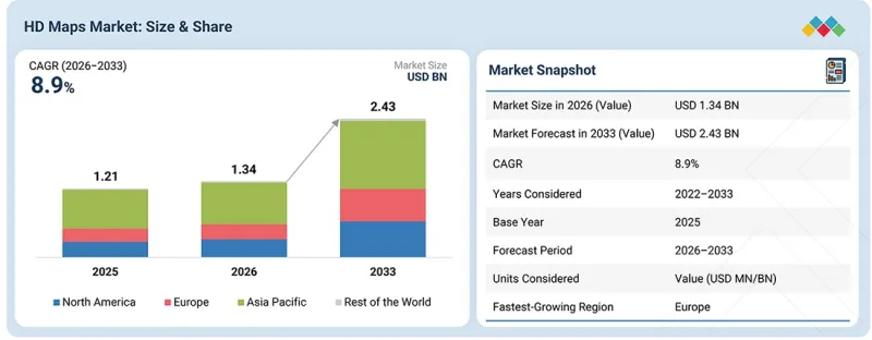
HD 맵 시장 규모는 2026년 13억 4,000만 달러에서 2033년까지 24억 3,000만 달러로 성장하며, CAGR은 8.9%에 달할 것으로 예측됩니다.
| 조사 범위 | |
|---|---|
| 조사 대상 기간 | 2026-2033년 |
| 기준연도 | 2025년 |
| 예측 기간 | 2026-2033년 |
| 대상 단위 | 10억 달러 |
| 부문 | 자동화 레벨별, 서비스 유형별, 솔루션 유형별, 사용 방법별, 차종별, 지역별 |
| 대상 지역 | 아시아태평양, 북미, 유럽 및 세계의 기타 지역 |
HD 지도 시장은 시맨틱 매핑의 부상과 함께 발전하고 있습니다. 시맨틱 매핑이란 단순히 도로를 표시하는 데 그치지 않고, 신호등, 횡단보도, 차선 표시 등의 객체를 해석하여 문맥 인식을 실현하는 기술입니다. 복잡한 도시 지역에서 센티미터 단위의 위치 파악을 지원하기 위해 고해상도 위치 파악 레이어가 통합되고 있습니다. 또한 차량 군 전체에 걸친 지도 갱신의 신뢰성과 안정성을 확보하기 위해 블록체인 및 안전한 데이터 공유 프레임워크를 활용하는 움직임도 새로운 동향으로 부상하고 있습니다. 더불어, 정확도를 유지하면서 자율주행차의 계산 부하를 경감하기 위해 에너지 효율이 뛰어난 매핑 기술이 주목받고 있습니다. HD 맵 데이터는 일반적으로 LiDAR, 카메라, GPS, 레이더를 탑재한 차량 플릿을 통해 수집되며, 상세한 도로 정보와 환경 정보가 지속적으로 획득 및 갱신됩니다. 이러한 크라우드소싱과 센서 퓨전을 결합한 접근 방식을 통해 자율주행에 필요한 맵의 정확성과 최신성이 확보됩니다. 지도 정확도 향상, 업데이트 주기 단축, 정확한 위치 파악, 그리고 처리 요구 사항의 감소를 통해 보다 고도화된 자율주행에서 HD 지도의 역할이 강화될 것이며, 복잡한 도시 도로, 고속도로 및 상용차 노선에서의 광범위한 도입이 촉진될 것입니다.
예측 기간 중 HD 지도 시장에서 임베디드형 솔루션이 큰 시장 점유율을 차지할 것으로 전망됩니다.
HD 지도에 대한 시장 수요는 지속적인 클라우드 연결에 대한 의존도를 낮추면서도 중요한 도로 정보를 차량 내에서 이용할 수 있도록 하는 임베디드 지도 아키텍처로 전환되고 있습니다. 이는 네트워크 지연이나 통신 사각지대가 지도 이용 가능성에 영향을 미칠 수 있는 일관된 위치 파악 및 차선 수준의 도로 컨텍스트가 필요한 기능에서 특히 중요합니다. 또한 각 HD 지도 제공업체들은 자율주행 기능을 위해 보다 상세한 도로 정보를 갖춘 내장형 지도 컨텐츠 개발을 추진하고 있습니다. 예를 들어 Dynamic Map Platform사의 ‘Automotive HD Map’은 차선 형태, 도로 경계, 교통 관련 속성 등 고정밀하고 상세한 도로 정보를 제공합니다. 또한 2026년 6월, TMAP Mobility는 2027년에 HD 지도 기반의 3D 차선 인식 내비게이션 시스템을 상용화할 계획을 발표했습니다. 이 시스템은 HD 지도를 차량 탑재형 고정밀 위치 측정 및 ADAS 센서 인식과 통합하여, 고속도로 및 자동차도에서 차선 수준의 안내를 제공합니다. 또한 시장은 차량의 소프트웨어 수명 주기 전반에 걸쳐 업데이트 가능한 임베디드형 지도로 전환되고 있습니다. 예를 들어 현대오토에버는 OTA를 통해 지도 및 내비게이션 업데이트를 배포하고 있으며, 물리적 서비스 개입 없이 차량 내에 저장된 지도 컨텐츠를 업데이트할 수 있습니다. 내장형 지도가 차량의 컴퓨팅, 센서 퓨전 및 OTA 인프라와 더욱 긴밀하게 연동됨에 따라 경쟁의 초점은 저지연 지도 액세스를 제공하면서도 차량내 지도 저장 공간, 업데이트 빈도 및 연결 요건을 효율적으로 관리할 수 있는 솔루션으로 이동하고 있습니다. 이러한 변화에 따라 로컬 가용성과 선택적 OTA 업데이트를 결합한 임베디드 HD 지도 아키텍처에 대한 수요가 증가하고 있으며, 이를 통해 각 OEM 업체는 자율주행 기능이 확대되는 가운데 차량내 저장 공간, 연결 의존도 및 업데이트에 따른 오버헤드를 관리하면서 신뢰할 수 있는 차선 수준의 컨텍스트를 유지할 수 있게 됩니다.
예측 기간 중 HD 지도 시장에서 자율주행차의 성장률이 가장 높을 것으로 전망됩니다.
자율주행차 부문의 성장은 승용차 및 상용차에서 레벨 4 자율주행의 핵심 데이터 레이어로서 HD 맵의 활용이 증가하고 있는 데 힘입고 있습니다. L2+/L3 시스템의 보급과 레벨 4 도입이 확대됨에 따라 특히 위치 파악, 차선 토폴로지, 예측 주행 분야에서 차선 수준의 정확한 도로 정보에 대한 수요가 높아지고 있습니다. 자율주행차가 더 광범위한 운용 영역으로 확대됨에 따라 HD 지도를 대규모로 제작, 갱신, 검증하는 능력은 지도의 정확도 그 자체만큼이나 중요해지고 있습니다. 예를 들어 2026년 5월, 메르세데스-벤츠는 2026년 말까지 독일의 일부 도시에서 도심내 지점 간(point-to-point) 자율주행 내비게이션 서비스를 제공하기 시작하고, 2027년 초까지 전국으로 확대할 계획이라고 발표했습니다. 이로써 자율주행은 더욱 복잡한 도시 환경으로 진출하게 됩니다. 이 시스템은 신호등, 차선 변경, 교통량이 많은 상황 등 복잡한 도시 환경에 대응하도록 설계되어 있으며, 상세한 도로 정보와 정확한 위치 파악에 대한 필요성이 높아지고 있습니다.
각 OEM 업체들은 HD 지도를 자율주행 기능에 직접 통합하고 있습니다. 예를 들어 메르세데스-벤츠는 ‘DRIVE PILOT’ 내에서 ‘HERE HD Live Map’을 활용하여 자율주행을 지원하고 있습니다. 마찬가지로 BMW도 고속도로용 자율주행 시스템 ‘Personal Pilot L3’에서 HD 지도 정보를 활용하고 있습니다. Tier 1 공급업체들은 HD 지도를 위치 파악 데이터 및 센서 데이터와 통합하고 있습니다. 예를 들어 보쉬는 차량이 생성한 레이더 및 영상 관측 데이터를 지도 데이터와 결합하고 있으며, ZF는 더 높은 수준의 차량 자동화를 지원하기 위해 고정밀 위치 파악 및 커넥티비티를 자율주행 아키텍처에 통합하고 있습니다. 상용차의 경우, HD 지도가 정의된 화물 운송 경로에서의 자율주행 확대를 지원하고 있습니다. 예를 들어 DAF Trucks는 레벨 4 자동 화물 운송 운용을 목표로 하는 MODI 프로젝트에서 HERE HD Live Map을 채택하고 있습니다. OEM 및 Tier 1 공급업체들이 HD 지도를 위치 파악, 인지,자율주행 아키텍처에 더욱 깊이 통합함에 따라 수요는 고정밀 지도 컨텐츠, 센서 기반 업데이트, 클라우드 연결 및 확장 가능한 지역적 커버리지로 이동하고 있으며, 이를 통해 HD 지도 제공업체가 더욱 진보된 자율주행 차량 플랫폼의 기술 파트너가 될 기회가 생겨나고 있습니다.
예측 기간 중 HD 지도 시장에서 유럽이 가장 높은 성장률을 보일 것으로 예상됩니다.
유럽에서는 첨단 승용차 기능을 위해 차선 수준의 도로 형태, 고정밀 위치 파악, 도로 속성 및 빈번하게 업데이트되는 정보를 제공하는 HD 지도 솔루션에 대한 수요가 점점 더 높아지고 있습니다. 기술적 요구 사항으로는 대규모 도로 네트워크 전체에 걸쳐 차선 수준의 데이터를 유지하고, 이 정보를 차량의 소프트웨어 플랫폼에 직접 통합하는 것이 요구됩니다. 유럽의 승용차 OEM 업체들은 자율주행 기능의 데이터 레이어로 HD 지도를 점점 더 많이 활용하고 있습니다. 예를 들어 폭스바겐 그룹의 소프트웨어 기업인 CARIAD는 자율주행 시스템에 TomTom Orbis Maps를 채택하고 있는 반면, 로터스는 유럽내 L2+ 주행 기능을 위해 ‘Highway Navigation Pilot’에 고정밀 지도 데이터를 통합하고 있습니다.
또한 유럽의 HD 지도는 도로 인프라와 주변의 물리적 상황을 더욱 상세하게 반영한, 더욱 풍부한 3D 표현으로 전환되고 있습니다. 예를 들어 ‘Dynamic Map Platform’은 고속도로 및 주요 간선도로의 고정밀 3D 포인트 클라우드 데이터를 제공하고 있습니다. 또한 ‘MINDY Support’는 ADAS 및 자율주행을 위해 기업 규모의 3D HD 지도 주석 부착 및 검증 서비스를 제공하고 있으며, 2026년 2월 기준으로 15,000건 이상의 도로 인프라 오브젝트를 커버하고 센티미터 단위의 위치 정확도 검사를 시행하고 있습니다. 유럽 전역에서 이러한 시장 변화로 인해 HD 지도 제공업체에게는 고정밀 차선 수준 데이터, 빈번하게 업데이트되는 도로 정보, 그리고 3D 도로 표현을 결합하여 승용차 자동화, ADAS 개발, 시뮬레이션, 검증 및 디지털 도로 애플리케이션을 지원할 수 있는 확장 가능한 플랫폼을 구축할 기회가 생겨나고 있습니다.
HD 맵 시장은 Baidu, Inc.(중국), Mobileye(이스라엘), TomTom International BV(네덜란드), NVIDIA Corporation(미국), HERE(네덜란드) 등의 주요 기업이 주도하고 있습니다. 이 기업은 자율주행 및 ADAS를 지원하도록 설계된, 실시간으로 업데이트되는 매우 상세한 차선 수준의 HD 지도를 제공하고 있습니다. 또한 동적 지도 레이어(교통 상황, 도로 상황, 기상 정보), 클라우드 기반 지도 배포 플랫폼, 크라우드소싱을 통한 데이터 통합, 센서 퓨전 솔루션, 경로 계획·위치 추정·내비게이션용 소프트웨어 툴와 같은 부가가치 서비스도 제공하고 있습니다.
조사 범위:
이 보고서에서는 서비스 유형(매핑·위치 추정, 업데이트·유지보수, 광고), 차종(PC 및 CV), 솔루션 유형(임베디드형 및 클라우드 기반), 이용 형태, 자동화 수준, 그리고 지역별로 HD 지도 시장을 분석하고 있습니다. 또한 HD 지도 시장 생태계내 주요 기업의 경쟁 현황과 기업 개요에 대해서도 포괄적으로 다루고 있습니다.
아울러, 본 조사에서는 주요 시장 참여자에 대한 상세한 경쟁 분석 외에도 기업 개요, 제품 및 사업 내용에 대한 주요 견해, 최근 동향, 주요 시장 전략에 대해서도 다루고 있습니다.
이 보고서를 구매할 때의 주요 이점:
- 이 보고서는 HD 지도 시장 전체 및 그 하위 부문의 매출 추정치에 대한 정보를 제공함으로써, 시장을 선도하는 기업과 신규 진입 기업을 지원합니다.
- 이 보고서는 이해관계자가 경쟁 구도를 이해하고, 자사의 비즈니스를 더 나은 위치로 이끌며, 적절한 시장 진입 전략을 수립하기 위한 추가적인 인사이트를 얻는 데 도움이 됩니다.
- 또한 이 보고서는 이해관계자가 시장 동향을 파악하는 데 도움을 주며, 주요 시장 촉진요인, 제약, 과제 및 기회에 대한 정보를 제공합니다.
이 보고서는 다음 사항에 대한 인사이트를 제공합니다. :
- 주요 촉진요인(정적인 HD 맵이 아닌 지속적으로 업데이트되는 HD 맵에 대한 OEM의 수요, 자율주행 및 위치 파악 스택에 대한 HD 맵 통합, L2 및 L3 ADAS 탑재 차량의 보급 확대) 분석, 제약 요인(차선 수준의 지도 커버리지 생성 및 유지에 드는 높은 비용,사전 제작된 HD 지도에 대한 의존도를 낮추기 위한 차량내 지각 능력 향상), 기회(확장 가능한 HD 지도의 제작 및 지속적인 업데이트를 가능하게 하는 차량 생성 데이터 및 ‘지도 서비스(Map-as-a-Service)’, 변화하는 도로 상황을 실시간으로 반영하기 위한 동적 HD 지도 및 4D 매핑의 채택 확대),그리고 과제(급격한 도로망 변화 속에서도 지도 정확도 유지 및 멀티센서 데이터의 복잡한 실시간 통합)에 대한 인사이트를 제공합니다.
- 제품 개발/혁신: HD 지도 시장의 향후 기술 및 연구개발 활동에 대한 상세 인사이트.
- 시장 개발: 수익성 높은 시장에 대한 포괄적인 정보-이 보고서에서는 다양한 지역의 HD 지도 시장을 분석하고 있습니다.
- 시장 다각화: HD 지도 시장의 미개발 지역, 최근 동향 및 투자에 대한 포괄적인 정보.
- 경쟁 분석: HD 지도 시장의 주요 기업인 HERE(네덜란드), Baidu, Inc.(중국), TomTom International BV(네덜란드), NVIDIA Corporation(미국), Mobileye(이스라엘)의 시장 점유율, 성장 전략 및 제품 라인업에 대한 상세한 평가.
자주 묻는 질문
목차
제1장 서론
제2장 개요
제3장 주요 인사이트
제4장 시장 개요
제5장 업계 동향
제6장 기술 진보, AI에 의한 영향, 특허, 혁신, 향후 응용
제7장 규제 상황과 지속가능성 구상
제8장 고객 상황과 구매 행동
제9장 HD 맵 시장(자동화 레벨별)
제10장 HD 맵 시장(서비스 유형별)
제11장 HD 맵 시장(솔루션 유형별)
제12장 HD 맵 시장(사용 방법별)
제13장 HD 맵 시장(차종별)
제14장 HD 맵 시장(지역별)
제15장 경쟁 구도
제16장 기업 개요
제17장 조사 방법
제18장 부록
KSAThe HD maps market is projected to grow from USD 1.34 billion in 2026 to USD 2.43 billion by 2033, at a CAGR of 8.9%.
| Scope of the Report | |
|---|---|
| Years Considered for the Study | 2026-2033 |
| Base Year | 2025 |
| Forecast Period | 2026-2033 |
| Units Considered | USD billion |
| Segments | LOA, Service Type, Vehicle Type, Solution Type, Usage, and Region |
| Regions covered | Asia Pacific, North America, Europe, and the Rest of the World |
The HD maps market is advancing with the rise of semantic mapping, where maps show roads and interpret objects such as traffic lights, crosswalks, and lane markings for contextual awareness. High-definition localization layers are being integrated to support centimeter-level positioning in complex urban areas. Another emerging trend is the use of blockchain and secure data-sharing frameworks to ensure reliability and trust in map updates across fleets. In addition, energy-efficient mapping techniques are gaining attention to reduce the computational load on autonomous vehicles while maintaining accuracy. Data for HD maps is typically collected through fleets of sensor-equipped vehicles using LiDAR, cameras, GPS, and radar, which continuously capture and update detailed road and environment information. This crowdsourced and sensor-fusion approach ensures maps remain precise and up to date for autonomous driving. Improved map accuracy, faster update cycles, precise localization, and lower processing requirements will strengthen the role of HD maps in higher levels of autonomous driving, supporting wider deployment across complex urban roads, highways, and commercial vehicle routes.
Embedded solution to hold a significant market share of the HD maps market during the forecast period.
Market demand for HD Maps is moving toward embedded map architectures that can keep critical road information available inside the vehicle while reducing dependence on continuous cloud connectivity. This is particularly relevant for functions requiring consistent localization and lane-level road context, where network latency or coverage gaps can affect map availability. HD map providers are also developing embedded map content with higher levels of road detail for automated driving functions. For instance, Dynamic Map Platform's Automotive HD Map provides high-precision, detailed road features, including lane geometry, road boundaries, and traffic-related attributes. Additionally, in June 2026, TMAP Mobility announced plans to commercialize its HD map-based 3D lane recognition navigation system in 2027, integrating HD maps with in-vehicle precise positioning and ADAS sensor recognition to provide lane-level guidance across highways and expressways. The market is also moving toward embedded maps that can be refreshed through the vehicle software lifecycle. For instance, Hyundai AutoEver distributes map and navigation updates through OTA, allowing map content stored in the vehicle to be updated without physical service intervention. As embedded mapping becomes more closely connected with vehicle computing, sensor fusion, and OTA infrastructure, competition is shifting toward solutions that can provide low-latency map access while efficiently managing map storage, update frequency, and connectivity requirements within the vehicle. This shift is strengthening demand for embedded HD map architectures that combine local availability with selective OTA updates, enabling OEMs to maintain reliable lane-level context while controlling onboard storage, connectivity dependence, and updating overhead as automated driving functions scale.
Autonomous vehicles are projected to grow at the fastest rate in the HD maps market during the forecast period.
The growth of the autonomous vehicles segment is being driven by the increasing use of HD maps as a core data layer for Level 4 autonomous driving in passenger cars and commercial vehicles. The expansion of L2+/L3 systems and emerging L4 deployment is increasing the need for precise, lane-level road intelligence, particularly for localization, lane topology, and predictive maneuvering. As autonomous vehicles expand into larger operating areas, the ability to create, update, and validate HD maps at scale is becoming as important as map accuracy itself. For instance, in May 2026, Mercedes-Benz announced that its urban point-to-point automated navigation would be available in selected German cities by the end of 2026, with nationwide rollout planned by early 2027, which is also moving automated driving into more complex urban environments. The system is designed for complex urban conditions including traffic lights, lane changes, and dense traffic, increasing the need for detailed road intelligence and precise localization.
OEMs are integrating HD maps directly into automated driving functions. For instance, Mercedes-Benz uses HERE HD Live Map within DRIVE PILOT to support autonomous driving. Similarly, BMW uses HD map information within its Personal Pilot L3 system for highway automated driving. Tier 1 suppliers are integrating HD maps with localization and sensor data. For instance, Bosch is combining vehicle-generated radar and video observations with map data, and ZF is integrating high-precision positioning and connectivity into its automated driving architecture to support higher levels of vehicle automation. For commercial vehicles, HD maps are supporting the expansion of automated driving across defined freight routes, such as DAF Trucks using HERE HD Live Map in the MODI project for Level 4 automated freight operations. As OEMs and Tier 1 suppliers integrate HD maps more deeply into localization, perception, and automated driving architectures, demand is shifting toward high-precision map content, sensor-based updates, cloud connectivity, and scalable geographic coverage, creating opportunities for HD map providers to become technology partners within higher automation vehicle platforms.
Europe is expected to grow at the fastest rate in the HD maps market during the forecast period.
In Europe, the demand is increasingly shifting toward HD map solutions that provide lane-level road geometry, high-precision positioning, road attributes, and frequently refreshed information for advanced passenger vehicle functions. The technical requirement is moving toward maintaining lane-level data across large road networks and integrating this information directly into vehicle software platforms. European passenger car OEMs are increasingly using HD maps as a data layer for automated driving functions. For instance, Volkswagen Group's software company CARIAD is using TomTom Orbis Maps for automated driving systems, while Lotus is integrating high-precision map data with its Highway Navigation Pilot for L2+ driving functions in Europe.
Additionally, HD maps in Europe are also moving toward richer 3D representations that capture road infrastructure and surrounding physical conditions in greater detail. For instance, Dynamic Map Platform provides high-precision 3D point cloud data of motorways and major arterial roads; MINDY Support has also provided enterprise-scale 3D HD map annotation and validation for ADAS and autonomous driving, covering more than 15,000 road infrastructure objects with centimeter-level positional accuracy checks as of February 2026. Across Europe, these market shifts are creating opportunities for HD map providers to combine high-precision lane-level data, frequently updated road information, and 3D road representations into scalable platforms that can support passenger vehicle automation, ADAS development, simulation, validation, and digital road applications.
In-depth interviews were conducted with CEOs, marketing directors, other innovation and technology directors, and executives from various key organizations operating in this market.
- By Company Type: OEM - 18%, Tier I - 74%, and Tier II/III - 8%
- By Designation: CXOs - 36%, Managers - 51%, and Executives - 13%
- By Region: North America - 24%, Europe - 30%, Asia Pacific - 38%, and RoW - 8%
The HD maps market is dominated by major players, including Baidu, Inc. (China), Mobileye (Israel), TomTom International BV (Netherlands), NVIDIA Corporation (US), and HERE (Netherlands). These companies offer highly detailed, lane-level HD maps with real-time updates, designed to support autonomous driving and ADAS. They also provide value-added services such as dynamic map layers (traffic, road conditions, and weather), cloud-based map delivery platforms, crowdsourced data integration, sensor fusion solutions, and software tools for path planning, localization, and navigation.
Research Coverage:
The report covers the HD maps market by Service Type (mapping & localization, update & maintenance, and advertisement), Vehicle Type (PC & CV), Solution Type (embedded & cloud-based), Usage Type, Level of Automation, and Region. It covers the competitive landscape and company profiles of the major HD maps market ecosystem players.
The study also includes an in-depth competitive analysis of key market players, along with company profiles, key observations on product and business offerings, recent developments, and key market strategies.
Key Benefits of Buying the Report:
- The report will help market leaders/new entrants with information on the closest approximations of revenue numbers for the overall HD maps market and its subsegments.
- This report will help stakeholders understand the competitive landscape and gain more insights to position their businesses better and plan suitable go-to-market strategies.
- The report also helps stakeholders understand the market pulse and provides information on key market drivers, restraints, challenges, and opportunities.
The report provides insight on the following pointers:
- Analysis of key drivers (Demand from OEMs for Continuously Refreshed rather than Static HD Maps, Integration of HD Maps into Autonomous Driving and Localization Stacks, and Increasing Adoption of L2 and L3 ADAS-Equipped Vehicles), restraints (High Cost of Creating and Maintaining Lane Level Map Coverage, and Increasing Capability of Onboard Perception to Reduce Dependence on Prebuilt HD Maps), opportunities (Vehicle Generated Data and Maps as a Service Enabling Scalable HD Map Creation and Continuous Updates, Growing Adoption of Dynamic HD Maps and 4D Mapping for Real Time Representation of Changing Road Conditions), and challenges (Maintaining Map Accuracy During Rapid Road Network Changes and Complex Real-time Merging of Multi-Sensor Data).
- Product Development/Innovation: Detailed insights on upcoming technologies and research & development activities in the HD maps market.
- Market Development: Comprehensive information about lucrative markets - the report analyzes the HD maps market across varied regions.
- Market Diversification: Exhaustive information about untapped geographies, recent developments, and investments in the HD maps market.
- Competitive Assessment: In-depth assessment of market share, growth strategies, and product offerings of leading players such as HERE (Netherlands), Baidu, Inc. (China), TomTom International BV (Netherlands), NVIDIA Corporation (US), and Mobileye (Israel) in the HD maps market.
TABLE OF CONTENTS
1 INTRODUCTION
- 1.1 STUDY OBJECTIVES
- 1.2 MARKET DEFINITION
- 1.3 STUDY SCOPE
- 1.3.1 MARKETS COVERED AND REGIONAL SCOPE
- 1.3.2 INCLUSIONS AND EXCLUSIONS
- 1.4 YEARS CONSIDERED
- 1.5 CURRENCY CONSIDERED
- 1.6 STAKEHOLDERS
- 1.7 SUMMARY OF CHANGES
2 EXECUTIVE SUMMARY
- 2.1 MARKET HIGHLIGHTS AND KEY INSIGHTS
- 2.2 KEY MARKET PARTICIPANTS: MAPPING OF STRATEGIC DEVELOPMENTS
- 2.3 DISRUPTIVE TRENDS IN HD MAPS MARKET
- 2.4 HIGH-GROWTH SEGMENTS
- 2.5 REGIONAL SNAPSHOT: MARKET SIZE, GROWTH RATE, AND FORECAST
3 PREMIUM INSIGHTS
- 3.1 ATTRACTIVE OPPORTUNITIES FOR PLAYERS IN HD MAPS MARKET
- 3.2 HD MAPS MARKET, BY SERVICE TYPE
- 3.3 HD MAPS MARKET, BY VEHICLE TYPE
- 3.4 HD MAPS MARKET, BY SOLUTION TYPE
- 3.5 HD MAPS MARKET, BY LEVEL OF AUTOMATION
- 3.6 HD MAPS MARKET, BY USAGE TYPE
- 3.7 HD MAPS MARKET, BY REGION
4 MARKET OVERVIEW
- 4.1 INTRODUCTION
- 4.2 MARKET DYNAMICS
- 4.2.1 DRIVERS
- 4.2.1.1 Shifting preference from static HD maps to updated map data
- 4.2.1.2 Rising integration of mapping, localization, and ADAS processing into shared software interfaces
- 4.2.1.3 Increasing adoption of L2 and L3 vehicles
- 4.2.2 RESTRAINTS
- 4.2.2.1 High costs of HD map creation and maintenance
- 4.2.2.2 Increasing capability of onboard perception
- 4.2.3 OPPORTUNITIES
- 4.2.3.1 Growing data generation from connected vehicles
- 4.2.3.2 Increasing reliance on dynamic HD maps and 4D mapping
- 4.2.4 CHALLENGES
- 4.2.4.1 Issues in maintaining map accuracy amid rapid road network changes
- 4.2.4.2 Complexities in achieving seamless multi-sensor fusion
- 4.2.1 DRIVERS
- 4.3 UNMET NEEDS AND WHITE SPACES
- 4.3.1 LACK OF STANDARDIZED HD MAP FORMATS AND INTERFACES ACROSS AUTONOMOUS DRIVING PLATFORMS
- 4.3.2 LIMITED COMMERCIAL MODELS FOR CONTINUOUS HD MAP UPDATES AND VEHICLE GENERATED MAP DATA
- 4.3.3 LACK OF SCALABLE MAP FRESHNESS AND AUTOMATED CHANGE VALIDATION
- 4.4 INTERCONNECTED MARKETS AND CROSS-SECTOR OPPORTUNITIES
- 4.5 STRATEGIC MOVES BY OEMS AND TIER-1/2/3 PLAYERS
5 INDUSTRY TRENDS
- 5.1 MACROECONOMIC OUTLOOK
- 5.1.1 INTRODUCTION
- 5.1.2 GDP TRENDS AND FORECAST
- 5.1.3 TRENDS IN GLOBAL MAPPING INDUSTRY
- 5.1.4 TRENDS IN GLOBAL AUTONOMOUS VEHICLE INDUSTRY
- 5.2 ECOSYSTEM ANALYSIS
- 5.3 SUPPLY CHAIN ANALYSIS
- 5.4 CASE STUDY ANALYSIS
- 5.4.1 MINDY SUPPORT DELIVERS ENTERPRISE-SCALE 3D HD MAP ANNOTATION AND VALIDATION FOR ADAS
- 5.4.2 HERE ENABLES HD MAP-BASED AUTOMATED DRIVING APPLICATIONS FOR GLOBAL OEMS
- 5.4.3 BAIDU AND TONGJI UNIVERSITY DEVELOP HISTORICAL MAP TRACKING FOR HD MAP CONSTRUCTION
- 5.4.4 MERCEDES-BENZ INTEGRATES HERE'S HD LIVE MAP INTO DRIVE PILOT SYSTEMS
- 5.4.5 INTELLIAS CONCEPTUALIZES, DEVELOPS, AND SCALES CLOUD-BASED HD MAPPING AND LOCATION DATA PLATFORM FOR AUTONOMOUS DRIVING
- 5.4.6 MAGNASOFT DEPLOYS AI-DRIVEN CONTINUOUS IMPROVEMENT PROCESSES THAT ENABLED REAL-TIME DETECTION OF CHANGES IN TRAFFIC PATTERNS AND ROAD CONDITIONS
- 5.4.7 INFOSYS ADOPTS MULTI-SOURCE HD MAPPING SOLUTION DESIGNED FOR ADAS IN URBAN ENVIRONMENTS
- 5.5 INVESTMENT AND FUNDING SCENARIO
- 5.6 TRADE ANALYSIS
- 5.6.1 IMPORT SCENARIO (HS CODE 852691)
- 5.6.2 EXPORT SCENARIO (HS CODE 852691)
- 5.7 KEY CONFERENCES AND EVENTS, 2026-2027
- 5.8 TRENDS/DISRUPTIONS IMPACTING CUSTOMER BUSINESS
6 TECHNOLOGICAL ADVANCEMENTS, AI-DRIVEN IMPACT, PATENTS, INNOVATIONS, AND FUTURE APPLICATIONS
- 6.1 KEY EMERGING TECHNOLOGIES
- 6.1.1 AI-BASED HD MAP GENERATION AND AUTOMATED FEATURE EXTRACTION
- 6.1.2 CROWD-SOURCED AND VEHICLE GENERATED HD MAPPING
- 6.1.3 DYNAMIC HD MAPS AND CONTINUOUS MAP UPDATING
- 6.1.4 CLOUD-BASED HD MAP PROCESSING AND DELIVERY
- 6.1.5 HIGH-PRECISION LOCALIZATION AND MAP MATCHING
- 6.2 COMPLEMENTARY TECHNOLOGIES
- 6.2.1 SENSOR FUSION
- 6.2.2 MACHINE LEARNING-POWERED MAP ANALYTICS
- 6.3 ADJACENT TECHNOLOGIES
- 6.3.1 DIGITAL TWIN AND SIMULATION
- 6.3.2 VEHICLE EDGE COMPUTING
- 6.4 TECHNOLOGY/PRODUCT ROADMAP
- 6.4.1 2D VS. 3D VS. 4D MAPPING
- 6.4.2 SEMANTIC HD MAPS
- 6.4.3 VECTORIZED HD MAPS
- 6.4.4 RASTER VS. VECTOR MAP ARCHITECTURE
- 6.4.5 CLOUD-BASED VS. EMBEDDED HD MAPS
- 6.4.6 EDGE/ONBOARD MAP PROCESSING
- 6.4.7 MAP HORIZON
- 6.4.8 HD MAP APIS AND DATA INTERFACES
- 6.4.9 ADASIS AND MAP DATA EXCHANGE
- 6.5 PATENT ANALYSIS
- 6.6 IMPACT OF AI/GEN AI ON HD MAPS MARKET
- 6.6.1 ACCELERATED MAP CREATION AND UPDATES
- 6.6.2 ENHANCED LOCALIZATION ACCURACY
- 6.6.3 COST REDUCTION THROUGH SYNTHETIC DATA
- 6.6.4 DYNAMIC MAP PERSONALIZATION
- 6.6.5 TOP USE CASES AND MARKET POTENTIAL
- 6.6.6 BEST PRACTICES FOLLOWED BY MANUFACTURERS/OEMS IN HD MAPS MARKET
- 6.6.7 CASE STUDIES RELATED TO AI/GEN IMPLEMENTATION IN HD MAPS MARKET
- 6.6.8 INTERCONNECTED ECOSYSTEM AND IMPACT ON MARKET PLAYERS
- 6.6.9 CLIENTS' READINESS TO ADOPT AI/GEN AI-INTEGRATED HD MAPS
- 6.7 PHASED ADOPTION STRATEGY OF HD MAPS IN AV ECOSYSTEM
- 6.7.1 ASSISTED DRIVING AND PILOT DEPLOYMENTS
- 6.7.2 LIMITED AUTONOMY IN CONTROLLED ENVIRONMENTS
- 6.7.3 EXPANDED COVERAGE AND REAL-TIME UPDATES
- 6.7.4 FULL AUTONOMY AND ECOSYSTEM INTEGRATION
- 6.8 HD MAP DATA FORMATS AND STANDARDIZATION LANDSCAPE
- 6.8.1 CORE COMPONENTS OF HD MAP DATA
- 6.8.1.1 Geometric layer
- 6.8.1.2 Semantic layer
- 6.8.1.3 Localization layer
- 6.8.1.4 Dynamic/Update layer
- 6.8.2 HD MAP: KEY STANDARDS AND FORMATS
- 6.8.1 CORE COMPONENTS OF HD MAP DATA
- 6.9 MNM INSIGHTS ON KEY INDUSTRY SOLUTIONS FOR LOCALIZATION
- 6.9.1 GNSS AND AUGMENTED POSITIONING
- 6.9.2 HD MAP-BASED LOCALIZATION
- 6.9.3 LIDAR AND CAMERA-BASED LOCALIZATION
- 6.9.4 SENSOR FUSION
- 6.9.5 V2X-ENABLED COOPERATIVE LOCALIZATION
- 6.10 EVOLVING BUSINESS MODELS FOR HD MAPPING IN AUTONOMOUS MOBILITY
- 6.10.1 LICENSING AND SUBSCRIPTION-BASED MODEL
- 6.10.2 CROWDSOURCED MAPPING AND DATA-AS-A-SERVICE (DAAS)
- 6.10.3 PAY-PER-USE MODEL
- 6.11 HYBRID MAPPING STRATEGIES FOR ENHANCING ADAS DEVELOPMENT
- 6.12 IMPACT OF MAPLESS AUTONOMY CONCEPT ON HD MAPS
- 6.13 ANALYSIS OF OEM HD MAPPING SOLUTIONS
- 6.14 HD MAPPING SERVICE PROVIDERS: COMPETITIVE LANDSCAPE
- 6.15 SUCCESS STORIES AND REAL-WORLD APPLICATIONS
- 6.15.1 WAYMO: COMMERCIAL ROBOTAXI OPERATIONS IN US
- 6.15.2 MOBILEYE REM: CROWDSOURCED HD MAPPING ACROSS EUROPE
- 6.15.3 BAIDU APOLLO GO: CHINA'S ROBOTAXI EXPANSION
- 6.15.4 DYNAMIC MAP PLATFORM: GLOBAL HD MAP DEPLOYMENT
- 6.16 FUTURE DEPLOYMENT AREAS FOR HD MAPS
- 6.16.1 AUTONOMOUS DELIVERY VEHICLES
- 6.16.2 PLATOONING SUPPORT
- 6.16.3 V2X INTEGRATION
- 6.16.4 DYNAMIC TRAFFIC ROUTING
- 6.16.5 FREIGHT CORRIDOR OPTIMIZATION
- 6.16.6 SMART CITY INTEGRATION
- 6.16.7 AUTONOMOUS RIDE HAILING AND SHUTTLES
- 6.17 HD MAP MONETIZATION AND REVENUE MODELS
- 6.17.1 MAP LICENSE
- 6.17.2 PER-VEHICLE LICENSING
- 6.17.3 ANNUAL SUBSCRIPTION
- 6.17.4 PER-KILOMETER PRICING
- 6.17.5 API-BASED PRICING
- 6.17.6 CLOUD MAP SUBSCRIPTION
- 6.17.7 UPDATE/MAINTENANCE FEES
- 6.17.8 DATA-AS-A-SERVICE
- 6.17.9 MAP-AS-A-SERVICE
- 6.17.10 REVENUE SHARING WITH OEMS
- 6.17.11 BUNDLED HD MAP + LOCALIZATION
- 6.17.12 BUNDLED MAP + ADAS SOFTWARE
- 6.18 OEM HD MAP DEPENDENCY AND STRATEGY ANALYSIS
- 6.18.1 OEM FLEET DATA STRATEGY
- 6.18.2 OEM-OWNED MAPPING ASSETS
- 6.18.3 OEM-MAP PROVIDER PARTNERSHIPS
- 6.18.4 OEM-CLOUD PROVIDER PARTNERSHIPS
- 6.18.5 OEM-AV SOFTWARE INTEGRATION
- 6.19 OEM MAP LOCALIZATION STRATEGY, BY REGION
- 6.19.1 ASIA PACIFIC
- 6.19.2 EUROPE
- 6.19.3 NORTH AMERICA
- 6.20 REGIONAL OEM STRATEGIES FOR HD MAP ADOPTION
- 6.21 HD MAP PROVIDER STRATEGIC CAPABILITY BENCHMARK
- 6.21.1 GLOBAL ROAD COVERAGE
- 6.21.2 MAP ACCURACY
- 6.21.3 MAP UPDATE CAPABILITY
- 6.21.4 CROWDSOURCED DATA SCALE
- 6.21.5 OEM INTEGRATION
- 6.21.6 AUTONOMOUS DRIVING CAPABILITY
- 6.21.7 COMMERCIAL MODEL
- 6.22 EVOLUTION OF HD MAPS FOR AUTONOMOUS DRIVING
- 6.22.1 EVOLUTION FROM SD MAPS TO DYNAMIC HD MAPS
- 6.22.2 EVOLUTION FROM STATIC MAP TO CONTINUOUSLY UPDATED MAP
- 6.23 HD MAPS: TOTAL COST OF OWNERSHIP ANALYSIS
- 6.23.1 OEM TOTAL COST OF OWNERSHIP PER VEHICLE
- 6.23.2 HD MAP SUPPLIER TOTAL COST OF OWNERSHIP PER KILOMETER
7 REGULATORY LANDSCAPE AND SUSTAINABILITY INITIATIVES
- 7.1 REGULATORY LANDSCAPE
- 7.1.1 REGULATORY BODIES, GOVERNMENT AGENCIES, AND OTHER ORGANIZATIONS
- 7.1.1.1 North America
- 7.1.1.2 Europe
- 7.1.1.3 Asia Pacific
- 7.1.1.4 RoW
- 7.1.2 KEY REGULATIONS
- 7.1.2.1 US
- 7.1.2.2 Germany
- 7.1.2.3 China
- 7.1.2.4 Japan
- 7.1.2.5 South Korea
- 7.1.2.6 UK
- 7.1.3 REGULATIONS AND INITIATIVES FOR ADAS
- 7.1.3.1 US
- 7.1.3.2 China
- 7.1.3.3 Japan
- 7.1.3.4 European Union
- 7.1.3.5 UK
- 7.1.3.6 Germany
- 7.1.3.7 France
- 7.1.3.8 India
- 7.1.4 NCAP REGULATIONS
- 7.1.4.1 US
- 7.1.4.2 Europe
- 7.1.4.3 Australia & New Zealand
- 7.1.4.4 South Korea
- 7.1.4.5 China
- 7.1.4.6 Latin America
- 7.1.4.7 Southeast Asia
- 7.1.4.8 India
- 7.1.1 REGULATORY BODIES, GOVERNMENT AGENCIES, AND OTHER ORGANIZATIONS
- 7.2 SUSTAINABILITY INITIATIVES
- 7.2.1 CHINA: INTELLIGENT CONNECTED VEHICLE AND DIGITAL ROAD INFRASTRUCTURE INITIATIVES
- 7.2.2 EUROPE: DIGITAL AND SUSTAINABLE TRANSPORT INFRASTRUCTURE INITIATIVES
- 7.2.3 US: SMART TRANSPORTATION AND CONNECTED VEHICLE INITIATIVES
- 7.2.4 JAPAN: SMART ROAD AND CONNECTED MOBILITY INITIATIVES
- 7.2.5 SOUTH KOREA: INTELLIGENT TRANSPORTATION AND AUTONOMOUS MOBILITY INITIATIVES
- 7.2.6 UAE: SMART MOBILITY AND DIGITAL ROAD INFRASTRUCTURE INITIATIVES
- 7.2.7 INDIA: INTELLIGENT TRANSPORTATION AND DIGITAL ROAD INFRASTRUCTURE INITIATIVES
- 7.2.8 GERMANY: SMART ROAD AND AUTOMATED DRIVING INFRASTRUCTURE INITIATIVES
- 7.3 IMPACT OF REGULATORY POLICIES ON SUSTAINABILITY INITIATIVES
8 CUSTOMER LANDSCAPE AND BUYER BEHAVIOR
- 8.1 DECISION-MAKING PROCESS
- 8.2 KEY STAKEHOLDERS INVOLVED IN BUYING PROCESS AND THEIR EVALUATION CRITERIA
- 8.2.1 KEY STAKEHOLDERS IN BUYING PROCESS
- 8.2.2 BUYING CRITERIA
- 8.3 ADOPTION BARRIERS AND INTERNAL CHALLENGES
- 8.3.1 MARKET PROFITABILITY
- 8.3.2 REVENUE POTENTIAL
- 8.3.3 COST DYNAMICS
- 8.3.4 MARGIN OPPORTUNITIES, BY APPLICATION
9 HD MAPS MARKET, BY LEVEL OF AUTOMATION
- 9.1 INTRODUCTION
- 9.2 SEMI-AUTONOMOUS VEHICLE
- 9.2.1 LEVEL 2/2+
- 9.2.1.1 Strong focus on safety, convenience, and ADAS regulation compliance to foster segmental growth
- 9.2.2 LEVEL 3
- 9.2.2.1 High emphasis on precise localization and safe driving during traffic congestion to boost segmental growth
- 9.2.1 LEVEL 2/2+
- 9.3 AUTONOMOUS VEHICLE
- 9.3.1 LEVEL 4
- 9.3.1.1 Ability to tackle complex driving situations and operate under pretrained or predefined conditions to fuel segmental growth
- 9.3.2 LEVEL 5
- 9.3.2.1 Focus on enabling fully driverless operation to contribute to segmental growth
- 9.3.1 LEVEL 4
- 9.4 KEY PRIMARY INSIGHTS
10 HD MAPS MARKET, BY SERVICE TYPE
- 10.1 INTRODUCTION
- 10.2 MAPPING & LOCALIZATION
- 10.2.1 RAPID ADVANCES IN AI, MACHINE LEARNING, AND SENSOR TECHNOLOGIES TO EXPEDITE SEGMENTAL GROWTH
- 10.3 UPDATE & MAINTENANCE
- 10.3.1 GROWING EMPHASIS ON MAINTAINING PRECISION IN AUTONOMOUS DRIVING AND ADJUSTING TO CHANGING ENVIRONMENTS TO DRIVE MARKET
- 10.4 ADVERTISEMENT
- 10.5 KEY PRIMARY INSIGHTS
11 HD MAPS MARKET, BY SOLUTION TYPE
- 11.1 INTRODUCTION
- 11.2 EMBEDDED
- 11.2.1 USE TO OFFER REAL-TIME, HIGH-PRECISION LOCALIZATION AND NAVIGATION TO AUGMENT SEGMENTAL GROWTH
- 11.3 CLOUD-BASED
- 11.3.1 ABILITY TO MAKE CONTINUOUS UPDATES AND PROCESS VAST AMOUNTS OF DATA FROM SENSORS AND CAMERAS TO SPUR DEMAND
- 11.4 KEY PRIMARY INSIGHTS
12 HD MAPS MARKET, BY USAGE TYPE
- 12.1 INTRODUCTION
- 12.2 PERSONAL MOBILITY
- 12.2.1 GROWING DEMAND FOR ADAS-EQUIPPED PASSENGER CARS TO ACCELERATE SEGMENTAL GROWTH
- 12.3 COMMERCIAL MOBILITY
- 12.3.1 RISING POPULARITY OF E-COMMERCE AND DEMAND FOR EFFICIENT DELIVERY AND TRANSPORT TO FUEL SEGMENTAL GROWTH
- 12.4 KEY PRIMARY INSIGHTS
13 HD MAPS MARKET, BY VEHICLE TYPE
- 13.1 INTRODUCTION
- 13.2 PASSENGER CAR
- 13.2.1 GROWING INTEGRATION OF ADAS AND SEMI-AUTONOMOUS FEATURES INTO MID- TO HIGH-END VEHICLES TO FACILITATE SEGMENTAL GROWTH
- 13.3 COMMERCIAL VEHICLE
- 13.3.1 HIGH EMPHASIS ON SUPPORTING ROUTE OPTIMIZATION, PREDICTIVE MAINTENANCE, AND LIVE TRAFFIC MONITORING TO DRIVE MARKET
- 13.4 KEY PRIMARY INSIGHTS
14 HD MAPS MARKET, BY REGION
- 14.1 INTRODUCTION
- 14.2 ASIA PACIFIC
- 14.2.1 INCREASING INVESTMENT IN AUTONOMOUS DRIVING AND ADVANCED MAPPING TECHNOLOGIES TO DRIVE MARKET
- 14.2.2 CHINA
- 14.2.3 INDIA
- 14.2.4 JAPAN
- 14.2.5 SOUTH KOREA
- 14.3 EUROPE
- 14.3.1 RISING REGULATORY FOCUS ON VEHICLE SAFETY AND AUTONOMOUS DRIVING TO FOSTER MARKET GROWTH
- 14.3.2 GERMANY
- 14.3.3 FRANCE
- 14.3.4 ITALY
- 14.3.5 SPAIN
- 14.3.6 UK
- 14.4 NORTH AMERICA
- 14.4.1 MOUNTING ADOPTION OF CONNECTED AND INTELLIGENT VEHICLE TECHNOLOGIES TO BOOST MARKET GROWTH
- 14.4.2 US
- 14.4.3 CANADA
- 14.4.4 MEXICO
- 14.5 ROW
- 14.5.1 INCREASING SMART MOBILITY INVESTMENT AND TECHNOLOGY PARTNERSHIPS TO AUGMENT MARKET GROWTH
- 14.5.2 BRAZIL
- 14.5.3 SOUTH AFRICA
- 14.5.4 RUSSIA
- 14.5.5 SAUDI ARABIA
- 14.5.6 UAE
15 COMPETITIVE LANDSCAPE
- 15.1 OVERVIEW
- 15.2 KEY PLAYER COMPETITIVE STRATEGIES/RIGHT TO WIN, 2024-2026
- 15.3 MARKET SHARE ANALYSIS, 2025
- 15.4 REVENUE ANALYSIS, 2021-2025
- 15.5 COMPANY VALUATION AND FINANCIAL METRICS
- 15.6 BRAND/PRODUCT COMPARISON
- 15.6.1 HERE (NETHERLANDS)
- 15.6.2 BAIDU (CHINA)
- 15.6.3 TOMTOM INTERNATIONAL BV (NETHERLANDS)
- 15.6.4 NVIDIA CORPORATION (US)
- 15.6.5 MOBILEYE (ISRAEL)
- 15.7 COMPANY EVALUATION MATRIX: KEY PLAYERS, 2025
- 15.7.1 STARS
- 15.7.2 EMERGING LEADERS
- 15.7.3 PERVASIVE PLAYERS
- 15.7.4 PARTICIPANTS
- 15.7.5 COMPANY FOOTPRINT: KEY PLAYERS, 2025
- 15.7.5.1 Company footprint
- 15.7.5.2 Region footprint
- 15.7.5.3 Usage type footprint
- 15.7.5.4 Vehicle type footprint
- 15.7.5.5 Level of automation footprint
- 15.8 COMPANY EVALUATION MATRIX: STARTUPS/SMES, 2025
- 15.8.1 PROGRESSIVE COMPANIES
- 15.8.2 RESPONSIVE COMPANIES
- 15.8.3 DYNAMIC COMPANIES
- 15.8.4 STARTING BLOCKS
- 15.8.5 COMPETITIVE BENCHMARKING: STARTUPS/SMES, 2025
- 15.8.5.1 Detailed list of key startups/SMEs
- 15.8.5.2 Competitive benchmarking of key startups/SMEs
- 15.9 COMPETITIVE SCENARIO
- 15.9.1 PRODUCT/SERVICE LAUNCHES/DEVELOPMENTS
- 15.9.2 DEALS
- 15.9.3 EXPANSIONS
- 15.9.4 OTHER DEVELOPMENTS
16 COMPANY PROFILES
- 16.1 KEY PLAYERS
- 16.1.1 HERE
- 16.1.1.1 Business overview
- 16.1.1.2 Products/Solutions/Services offered
- 16.1.1.3 Recent developments
- 16.1.1.3.1 Deals
- 16.1.1.3.2 Other developments
- 16.1.1.4 MnM view
- 16.1.1.4.1 Key strengths/Right to win
- 16.1.1.4.2 Strategic choices
- 16.1.1.4.3 Weaknesses/Competitive threats
- 16.1.2 BAIDU
- 16.1.2.1 Business overview
- 16.1.2.2 Products/Solutions/Services offered
- 16.1.2.3 Recent developments
- 16.1.2.3.1 Deals
- 16.1.2.4 MnM view
- 16.1.2.4.1 Key strengths/Right to win
- 16.1.2.4.2 Strategic choices
- 16.1.2.4.3 Weaknesses/Competitive threats
- 16.1.3 TOMTOM INTERNATIONAL BV
- 16.1.3.1 Business overview
- 16.1.3.2 Products/Solutions/Services offered
- 16.1.3.3 Recent developments
- 16.1.3.3.1 Product/Service launches/enhancements
- 16.1.3.3.2 Deals
- 16.1.3.3.3 Other developments
- 16.1.3.4 MnM view
- 16.1.3.4.1 Key strengths/Right to win
- 16.1.3.4.2 Strategic choices
- 16.1.3.4.3 Weaknesses/Competitive threats
- 16.1.4 NVIDIA CORPORATION
- 16.1.4.1 Business overview
- 16.1.4.2 Products/Solutions/Services offered
- 16.1.4.3 Recent developments
- 16.1.4.3.1 Deals
- 16.1.4.4 MnM view
- 16.1.4.4.1 Key strengths/Right to win
- 16.1.4.4.2 Strategic choices
- 16.1.4.4.3 Weaknesses/Competitive threats
- 16.1.5 MOBILEYE
- 16.1.5.1 Business overview
- 16.1.5.2 Products/Solutions/Services offered
- 16.1.5.3 Recent developments
- 16.1.5.3.1 Deals
- 16.1.5.3.2 Other developments
- 16.1.5.4 MnM view
- 16.1.5.4.1 Key strengths/Right to win
- 16.1.5.4.2 Strategic choices
- 16.1.5.4.3 Weaknesses/Competitive threats
- 16.1.6 WAYMO LLC
- 16.1.6.1 Business overview
- 16.1.6.2 Products/Solutions/Services offered
- 16.1.6.3 Recent developments
- 16.1.6.3.1 Deals
- 16.1.6.3.2 Expansions
- 16.1.6.3.3 Other developments
- 16.1.7 DYNAMIC MAP PLATFORM CO., LTD.
- 16.1.7.1 Business overview
- 16.1.7.2 Products/Solutions/Services offered
- 16.1.7.3 Recent developments
- 16.1.7.3.1 Product/Service launches/enhancements
- 16.1.7.3.2 Deals
- 16.1.7.3.3 Expansions
- 16.1.7.3.4 Other developments
- 16.1.8 NAVINFO CO., LTD.
- 16.1.8.1 Business overview
- 16.1.8.2 Products/Solutions/Services offered
- 16.1.8.3 Recent developments
- 16.1.8.3.1 Deals
- 16.1.8.3.2 Other developments
- 16.1.9 THE SANBORN MAP COMPANY, INC.
- 16.1.9.1 Business overview
- 16.1.9.2 Products/Solutions/Services offered
- 16.1.9.3 Recent developments
- 16.1.9.3.1 Developments
- 16.1.10 MOMENTA
- 16.1.10.1 Business overview
- 16.1.10.2 Products/Solutions/Services offered
- 16.1.11 MAPBOX
- 16.1.11.1 Business overview
- 16.1.11.2 Products/Solutions/Services offered
- 16.1.11.3 Recent developments
- 16.1.11.3.1 Product/Service launches/enhancements
- 16.1.11.3.2 Deals
- 16.1.12 CE INFO SYSTEMS LTD.
- 16.1.12.1 Business overview
- 16.1.12.2 Products/Solutions/Services offered
- 16.1.12.3 Recent developments
- 16.1.12.3.1 Deals
- 16.1.1 HERE
- 16.2 OTHER PLAYERS
- 16.2.1 NAVMII
- 16.2.2 RMSI
- 16.2.3 ZENRIN CO., LTD.
- 16.2.4 WOVEN BY TOYOTA, INC.
- 16.2.5 SWIFT NAVIGATION, INC.
- 16.2.6 EXLSERVICE HOLDINGS, INC.
- 16.2.7 ROBOTIC DATA
- 16.2.8 HYUNDAI AUTOEVER CORP.
- 16.2.9 GENESYS INTERNATIONAL CORPORATION LTD
- 16.2.10 GEOMATE
- 16.2.11 INTELLIAS
- 16.2.12 MORAI INC.
- 16.2.13 TRIMBLE INC.
17 RESEARCH METHODOLOGY
- 17.1 RESEARCH DATA
- 17.1.1 SECONDARY DATA
- 17.1.1.1 List of key secondary sources
- 17.1.1.2 Key data from secondary sources
- 17.1.2 PRIMARY DATA
- 17.1.2.1 Key data from primary sources
- 17.1.2.2 Key industry insights
- 17.1.2.3 List of primary interview participants
- 17.1.2.4 Breakdown of primary interviews
- 17.1.1 SECONDARY DATA
- 17.2 MARKET SIZE ESTIMATION
- 17.2.1 TOP-DOWN APPROACH
- 17.2.2 MARKET FORECAST APPROACH
- 17.2.2.1 Supply side
- 17.2.2.2 Demand side
- 17.3 DATA TRIANGULATION
- 17.4 FACTOR ANALYSIS
- 17.5 RESEARCH ASSUMPTIONS
- 17.6 RESEARCH LIMITATIONS
- 17.7 RISK ANALYSIS
18 APPENDIX
- 18.1 DISCUSSION GUIDE
- 18.2 KNOWLEDGESTORE: MARKETSANDMARKETS' SUBSCRIPTION PORTAL
- 18.3 CUSTOMIZATION OPTIONS
- 18.3.1 HD MAPS MARKET, BY SEMI AUTONOMOUS VEHICLES, AT REGIONAL LEVEL
- 18.3.2 HD MAPS MARKET, BY AUTONOMOUS VEHICLES, AT REGIONAL LEVEL
- 18.3.3 HD MAPS MARKET, BY VEHICLE TYPE, BY LEVEL OF AUTOMATION
- 18.3.4 COMPANY INFORMATION
- 18.3.4.1 Profiling of additional market players (up to five)
- 18.4 RELATED REPORTS
- 18.5 AUTHOR DETAILS


