|
시장보고서
상품코드
1687955
공중촬영 시장 : 시장 점유율 분석, 산업 동향 및 통계, 성장 예측(2025-2030년)Aerial Imaging - Market Share Analysis, Industry Trends & Statistics, Growth Forecasts (2025 - 2030) |
||||||
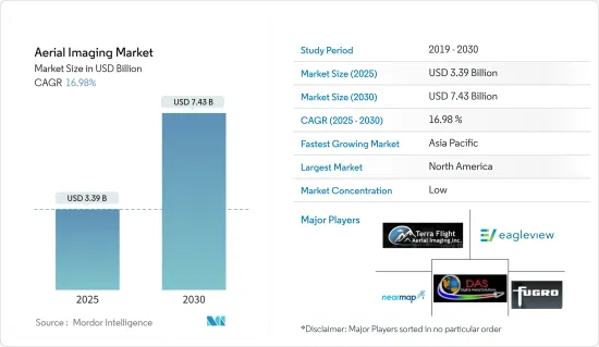
공중촬영 시장 규모는 2025년에 33억 9,000만 달러로 추정되고, 2030년에는 74억 3,000만 달러에 이를 것으로 예측되며, 예측 기간 2025년부터 2030년까지 CAGR 16.98%로 성장할 전망입니다.
공중촬영과 그 비디오 이미지로의 진화는 30년 이상 다양한 소형 항공 플랫폼을 사용하여 촬영되어 왔습니다. 라디콘 모델 비행기, 소형 35mm SLR을 사용하는 헬리콥터, 경량 캠코더 등의 소형 플랫폼은 컬러, 펑크로매틱, 컬러 적외선(CIR), 멀티스펙트럼 공중촬영을 획득하는 데 사용되며, 광범위한 용도로 사용되어 왔습니다.
시장은 RTF(Ready-to-Fly) 장치, 소프트 카피 사진 측량 소프트웨어, 저가형 디지털 카메라, 이미지 처리, GPS, 열, 다중 스펙트럼, 하이퍼 스펙트럼, LiDAR 센서의 기술 개척에 의해 강화되었습니다. UAV는 작은 면적 조사를 위해 고해상도 사진과 4K 비디오 데이터 세트를 얻는 고급 수단입니다.
공중촬영은 GPS를 사용하여 정확한 위치 지정을 지원합니다. 예를 들어, 농부는 GPS를 이용하여 농작물의 건강 상태를 모니터링하고, 문제점을 확인하고, 비료를 살포합니다. 에너지 및 전력 용지의 관리는 날씨에 의한 손상을 수리하고 보다 정확하게 목표를 정할 수 있기 때문에 공중촬영 정밀도의 혜택을 받습니다.
경찰도 공중촬영을 사용하여 만든 지도를 이용하고 있습니다. 경찰서는 필수품의 이동, 물리적 거리의 표지의 설치, 노동력의 할당, 격리 센터의 설치 장소의 결정, 핫스팟으로부터 인근의 병원이나 경찰서에 대한 표지, 긴급시에 이동하기 쉬운 최단 루트 등에 사용하고 있습니다.
COVID-19의 대유행으로 공중촬영 수요가 높아지고 있습니다. 이 이미지는 바이러스의 경제적 영향을 조사하고 인프라와 시설을 원격으로 모니터링하는 데 사용됩니다. 정부, 에너지, 전력, 석유 및 가스 등 다양한 업계 수요가 증가하였습니다. 또한 팬데믹의 최고점에서 이미지로 공급망의 상황을 모니터링했습니다.
드론 측량의 동향은 이미 주류가 되고 있지만, 팬데믹은 그 스케일을 크게 기울였습니다. UAV는 비접촉으로 작업을 수행할 수 있기 때문에 COVID-19의 팬데믹 시에 의지할 수 있는 기술이 되었습니다. UAV는 병원과 COVID-19 시험 센터를 건설할 수 있는 지역의 조사와 지도 작성, 그러한 장소의 감시에 중요한 역할을 하고 있습니다.
공중촬영 시장 동향
정부가 공중촬영의 가장 큰 최종 사용자가 될 전망
공중촬영은 다양한 지자체, 주, 연방 정부의 계획 용도에 필수적입니다. 또, 지도 작성 프로세스에도 빠뜨릴 수 없는 것이 되고 있습니다. 공중촬영은 그 장소의 물리적, 문화적 환경을 특정 순간에 반영합니다.
이러한 공중촬영이 적절하게 이해되면 지리학자, 역사가, 생태학자, 지질학자, 도시 계획가, 고고학자 및 기타 전문가에게 조사에 중요한 그림의 기초가 됩니다. 변호사는 종종 소유권 분쟁, 수리권, 교통권과 관련된 문제를 판단하기 위해 공중촬영을 사용합니다. 최근에는 계도학자가 조상 위치를 발견하고 찾아내기 위해 공중촬영을 사용하고 있습니다.
정부의 무인 항공기 사용은 무인 항공기 프로젝트 및 애플리케이션이 있는 부서 수에 따라 빠르게 증가하고 있습니다. 야심찬 정부 조직과 부서는 교통과 유틸리티부터 계획과 환경 서비스에 이르기까지 새로운 직역에서 실험을 진행하고 있습니다.
미국 정부는 전장에 배치될 수 있는 신병기의 실험을 실시했습니다. 전장에서 우위를 차지하는 것은 전쟁의 존속과 성공에 필수적입니다. 무인 항공기(UAV)는 지난 세기라고는 할 수 없지만 지난 수십 년간 군사 분쟁에서 가장 중요한 발명품입니다.
예를 들어, 미국 지질 조사소의 어퍼 미드 웨스트 환경 과학 센터는 최근 해양 에너지 관리국 및 미국 어류 야생 생물국과 제휴했습니다. 버클리 캘리포니아 대학의 국제 컴퓨터 과학 연구소의 비전 그룹은 디지털 공중촬영에서 바다 거북과 기타 해양 생물을 자동으로 식별, 열거, 분류 및 주석을 달리는 딥러닝 알고리즘과 도구를 만듭니다.
자각의 유무에 관계없이 대부분의 사람들이 공중촬영을 사용합니다. 공중촬영은 Google Images 및 Google 어스와 같은 기본적인 용도부터 범죄를 줄이기 위해 공중촬영을 사용하는 경찰기관과 같은 복잡한 용도에 이르기까지 모든 규모와 분야의 개인 및 조직의 시간과 비용을 절약할 수 있습니다.
공중 촬영에 의한 물새의 개체수 조사는 포획 및 기타 규제의 결정, 환경 평가, 미국의 해양 에너지 개발 프로젝트에서 야생 생물에 대한 영향 예측에 영향을 줄 수 있습니다. 대서양외 대륙붕과 오대호 항공기 조사에서 수집한 고해상도 디지털 이미지는 알고리즘 개발을 위한 데이터와 동물의 분포와 풍부함에 대한 기준 정보를 제공합니다.
공중촬영은 정부, 전문적 대응 및 복구 조직, 지역사회 및 사람들이 예상되는 임박하거나 실제로 발생한 위험의 결과와 상황을 예측, 대응 및 회복하는 데 도움이 됩니다. 많은 정부 부문에서 공중촬영의 이용이 증가하고 있기 때문에 세계적으로 공중촬영 수요가 높아지고 있습니다.
북미가 큰 시장 점유율을 차지합니다.
북미는 이 지역 기업의 첨단 조사와 이 지역의 최종 사용자 산업에서 기술 채용 증가로 조사 시장의 주요 투자자 및 채용자 중 하나가 되었습니다.
공중촬영은 포지티브 프로젝션 이미지에서 얻은 공간 데이터를 사용하여 토지 코팅, 식물, 토양 및 지질도 정보를 추출합니다. 또한 내륙과 부동산 정보, 고고학, 환경조사, 재해 및 긴급 대응 관리 등 정부기반의 용도에도 사용되고 있습니다. 그리고 공중촬영은 지표를 정확하게 표현하기 위해 중요한 계획, 지도 및 예보를 개발하는 데 사용됩니다. 또한 공중촬영은 엔지니어, 플래너, 개발자들 사이에서 토지 매핑과 개발에 각광을 받고 있습니다.
시장 확대는 재해 관리, 군사, 임업 및 도시 계획 용도에서 공중촬영 플랫폼의 채택 증가를 촉진하는 주요 요인입니다. 공중촬영 및 매핑 플랫폼의 사용은 도로 계획 및 부동산 관리에서 도시 계획자들 사이에서 확대되고 있으며 토지 이용 계산에 사용됩니다. 이 지역에서는 주요 공중촬영 솔루션 제공업체가 AI와 머신러닝 기술을 활용한 신제품 개발에 주력하고 있기 때문에 공중촬영 플랫폼의 보급이 진행되고 있습니다.
또한 북미 농업은 주로 산업화되어 농업 사업을 지원하는 통합 시스템에 의존하게 되었지만 멕시코에서는 독자적인 전통이 여전히 실천되고 있습니다. 미국과 캐나다의 대부분의 농부들은 주로 기술에 의존합니다. 기술 기업은 센서, 현장 카메라, 무인 항공기 및 비행기를 통한 공중 촬영 이미지, 위성 이미지 데이터 등 여러 데이터 소스를 통해 농부에게 인사이트를 제공하기 위해 노력해 왔습니다. 이러한 이미지 데이터 소스는 강력한 컴퓨팅 리소스, 방대한 데이터 스토리지 기능 및 인사이트를 얻는 데 시간이 필요합니다.
또한 이 지역의 건설활동에서는 공중촬영 수요가 지속적으로 증가하고 있습니다. 예를 들어 드론 기술을 사용하면 현장 엔지니어가 작업 진행 상황을 추적하고 이러한 불일치를 보다 효율적으로 모니터링할 수 있습니다.
게다가 미국 정부가 역사적인 인프라 정비법안을 제출함으로써 건설 업계는 건설 업계에 대한 정부지출 증가로 인한 투자의 대폭적인 증가에 대비하고 있습니다. 도로, 다리 및 기타 중요한 인프라 프로젝트에 1,100억 달러가 확보됨에 따라, 계약자와 측량사는 국내의 다양한 토목 건설 프로젝트를 감독하기 위해 큰 수요가 예상됩니다.
기술의 이용 확대와 현장 영역의 검사, 감시, 모니터링을 위한 기술의 이점에 대한 수요를 뒷받침하고 있는 정부 건설 프로젝트의 수 등의 요인이 시장 성장의 중요한 이유입니다.
공중촬영 산업 개요
공중촬영 시장은 세분화되어 있으며, 많은 업계 기업들이 시장의 잠재력을 찾고 있습니다. 이 업계의 마케팅 및 광고 수준도 성장하고 있으며 기업 집중률은 중간 정도로 성장하고 있습니다. 주요 진출기업으로는 Terra Flight Aerial Imaging Inc., Fugro Ltd., Nearmap Ltd., Eagle View Technologies Inc., Digital Aerial Solutions LLC 등이 있습니다.
2023년 2월-온다스는 완전 자회사인 아메리칸 로보틱스와 아이로보틱스의 통합 드론 사업을 총괄하는 온다스 오토노머스 시스템즈의 설립을 발표했습니다. 철도, 에너지, 광업, 농업, 공공 안전, 중요 인프라, 정부 시장에서 Ondas Networks와 Ondas Autonomous Systems는 연결, 데이터 수집 능력, 데이터 수집 및 정보 처리 능력 향상을 사용자에게 제공합니다.
2024년 4월-인프라 솔루션에 특화된 전국적인 엔지니어링 서비스 회사인 Bowman Consulting Group Ltd는 지리공간 및 엔지니어링 서비스로 알려져 있으며, 다양한 고도의 디지털 오르소 이미지, LiDAR 기술, 디지털 매핑, 수로도, 재해 매핑을 제공하는 Surdex Corporation을 인수함으로써 최종 합의. 원래는 공중촬영 회사였지만, 디지털 화상과 지도 작성으로 발전했습니다. 이 회사는 단발기, 쌍발기, 무인 항공기(UAV)를 포함한 10대의 항공기를 보유하고 있으며 공공 및 민간 부문 고객의 지리 공간 요구에 대응할 수 있습니다.
기타 혜택 :
- 엑셀 형식 시장 예측(ME) 시트
- 3개월간의 애널리스트 서포트
목차
제1장 서론
- 조사 전제조건 및 시장 정의
- 조사 범위
제2장 조사 방법
제3장 주요 요약
제4장 시장 인사이트
- 시장 개요
- 산업 밸류체인 분석
- 업계의 매력도-Porter's Five Forces 분석
- 공급기업의 협상력
- 구매자의 협상력
- 신규 참가업체의 위협
- 대체품의 위협
- 경쟁 기업간 경쟁 관계의 강도
- COVID-19의 업계에 대한 영향 평가
제5장 시장 역학
- 시장 성장 촉진요인
- 위치 정보 서비스의 상승
- 다양화하는 용도에서 수요 증가
- 시장 성장 억제요인
- 보안 및 프라이버시 문제
- 엄격한 정부 규제
제6장 시장 세분화
- 플랫폼 유형별
- 고정익기
- 헬리콥터
- UAV 및 드론
- 기타 플랫폼 유형
- 용도별
- 지리공간 매핑
- 인프라 계획
- 자산 목록 관리
- 환경 모니터링
- 국가 및 도시 매핑
- 감시 및 모니터링
- 재해 관리
- 기타 용도
- 최종 사용자 산업별
- 건설
- 항공우주 및 방위
- 정부기관
- 석유 및 가스
- 에너지 및 전력
- 농업
- 기타 최종 사용자 산업
- 지역별
- 북미
- 유럽
- 아시아태평양
- 세계 기타 지역
제7장 경쟁 구도
- 기업 프로파일
- Terra Flight Aerial Imaging Inc.
- Fugro Ltd
- Nearmap Ltd
- Eagle View Technologies Inc.
- Digital Aerial Solutions LLC
- Dronegenuity
- Cooper Aerial Surveys Co.
- Landiscor Real Estate Mapping
- Kucera International Inc.
- GeoVantage Inc.(Aeroptic LLC)
- Global UAV Technologies Ltd(High Eye Aerial Imaging Inc.)
- Eagle Aerial Solutions
- Aerobotics,(Pty) Ltd
- Airobotics GmbH(ONDAS Holdings)
- SkyIMD Inc.
제8장 투자 분석
제9장 시장의 미래
AJY 25.04.07The Aerial Imaging Market size is estimated at USD 3.39 billion in 2025, and is expected to reach USD 7.43 billion by 2030, at a CAGR of 16.98% during the forecast period (2025-2030).

Aerial imaging and its evolution into video imagery have been captured using various small aerial platforms for over three decades. Small-scale platforms such as radio-controlled model aircraft, helicopters that use small 35 mm SLR, and light-weighted video cameras have been used to acquire color, panchromatic, color infrared (CIR), and multispectral aerial photography for a wide range of applications.
The market has been augmented by the technology development of ready-to-fly (RTF) devices, soft-copy photogrammetry software, low-cost digital cameras, image processing, GPS, thermal, multispectral, hyperspectral, and LiDAR sensors. UAVs have become a sophisticated means of acquiring high-resolution photographic and 4K video datasets for small-area coverage studies.
Aerial imaging uses GPS, which aids in precise location. For instance, farmers use GPS targeting to monitor the health of the crops, identify problem areas, and spray fertilizer. Energy and power site management benefits from the precision of aerial imaging, as it can be repaired from weather damages and targeted more accurately.
Police departments also use maps that are being created using aerial imagery. The department uses it for the movement of essential items, placing physical distancing markers, workforce allocation, deciding where to set up isolation centers, marking nearby hospitals and police stations from hotspots, and the shortest routes for easy movement in an emergency.
The COVID-19 pandemic has led to increased demand for aerial imagery. This imagery is used to study the virus's economic impact and remotely monitor infrastructure and facilities. The demand increased from various industries, including government, energy, power, oil, and gas. Also, the imagery monitored supply chain situations during the pandemic's peak.
Although the trend of drone surveying is already becoming mainstream, the pandemic tipped the scale in its favor substantially. UAVs have become a go-to technology during the COVID-19 pandemic because they can accomplish tasks without contact. They have played a crucial role in surveying and mapping areas where hospitals and COVID-19 test centers can be built and monitoring such sites.
Aerial Imaging Market Trends
The Government is Expected to be the Largest End User of Aerial Imaging
Aerial imaging has become vital for various municipal, state, and federal government planning applications. It has also become an integral aspect of the mapmaking process. Aerial images reflect a location's physical and cultural environment at a particular moment.
When properly understood, these aerial photographs give geographers, historians, ecologists, geologists, urban planners, archaeologists, and other experts a graphical foundation that is frequently important to their research. Lawyers increasingly use aerial photography to decide matters involving property disputes, riparian rights, and transportation rights-of-way. Recently, genealogists have employed aerial photography to discover and find ancestral locations.
Government drone use is quickly rising due to the number of departments with drone projects and applications. Ambitious government organizations and departments are experimenting with new job areas, from transportation and public works to planning and environmental services.
The US government has experimented with new weaponry that may be deployed on the battlefield. Gaining an edge on the battlefield is crucial to a war's survival and success. Uncrewed aerial vehicles (UAVs) have been the most significant invention in military conflict in recent decades, if not the preceding century.
For example, the United States Geological Survey's Upper Midwest Environmental Sciences Center has recently partnered with the Bureau of Ocean Energy Management and the US Fish and Wildlife Service. The Vision Group at the International Computer Science Institute at the University of California, Berkeley, will create deep learning algorithms and tools for the automatic identification, enumeration, categorization, and annotation of sea ducks and other marine creatures from digital aerial imagery.
Most individuals utilize aerial images, whether they realize it or not. Aerial imagery may help individuals and organizations of all sizes and sectors save time and money, from basic applications like Google Images or Google Earth to complicated applications like police agencies using it to reduce crime.
Airborne waterfowl population surveys can influence harvest and other regulatory decisions, environmental evaluations, and impact estimates of prospective wildlife exposure to offshore energy development projects in the United States. High-resolution digital images collected during aircraft surveys of the Atlantic Outer Continental Shelf and the Great Lakes will provide data for algorithm development and baseline information on animal distributions and abundance.
Aerial pictures can help governments, professional response and recovery organizations, communities, and people anticipate, respond to, and recover from the consequences of expected imminent or actual hazard occurrences or circumstances. The increasing aerial photography usage in many government sectors has increased the demand for aerial pictures worldwide.
North America to Hold a Significant Market Share
North America is one of the major investors and adopters of the studied market due to the high level of research done by the regional companies and the increasing adoption of the technologies among the regional end-user industries.
Aerial imaging extracts information on land cover, vegetation, soil, and geology maps using spatial data captured from orthographic images. It is also used in government-based applications such as inland and property information, archaeology, environment studies, and disaster and emergency response management. Aerial imaging is then used to develop plans, maps, and forecasts crucial for accurately presenting the Earth's surface. Also, aerial imaging is gaining prominence among engineers, planners, and developers in land mapping and development.
Market expansion is the primary factor driving the increased adoption of aerial imaging platforms in disaster management, military, forestry, and urban planning applications. The use of aerial imaging and mapping platforms is growing among urban planners in road planning and real estate management, and they are used in land use calculations. The region exhibits a strong uptake of aerial imaging platforms due to major aerial imaging solution providers focusing on new product developments powered by AI and machine learning technologies.
In addition, agriculture in North America has become chiefly industrialized and reliant on an integrated system of supporting agribusinesses; however, original traditions are still practiced in Mexico. Most farmers in the United States and Canada rely primarily on technology. Technology companies have been working to provide insights to farmers through multiple data sources, including sensors, in-field cameras, aerial imagery gathered by drones and airplanes, and satellite imagery data. These imagery data sources require powerful computing resources, massive data storage capabilities, and time to generate insights.
Moreover, the demand for aerial imaging in the region's construction activity is increasing continuously. For instance, with drone technology, field engineers can track job progress and monitor these inconsistencies more efficiently.
Additionally, with the US government's historic infrastructure bill, the construction industry braced for a substantial boost in investment by increasing government spending on the construction industry. Contractors and surveyors are expected to be in great demand to oversee various civil construction projects around the country, with USD 110 billion set aside for roads, bridges, and other significant infrastructure projects.
Factors such as the growing use of technologies and the number of government construction projects that have boosted the demand for the benefits of technologies for the inspection, monitoring, and surveillance of the site area are critical reasons for the market's growth.
Aerial Imaging Industry Overview
The aerial imaging market is fragmented, with many industry players exploring the market potential. This industry's marketing and advertising level is also growing, while the firm concentration ratio is moderate and growing. Some of the major players in the market are Terra Flight Aerial Imaging Inc., Fugro Ltd, Nearmap Ltd, Eagle View Technologies Inc., and Digital Aerial Solutions LLC.
February 2023 - Ondas announced the creation of Ondas Autonomous Systems to oversee the integrated drone operations of wholly owned subsidiaries American Robotics and Airobotics. In the rail, energy, mining, agricultural, public safety, critical infrastructure, and government markets, Ondas Networks and Ondas Autonomous Systems provide users with increased connection, data gathering capabilities, and data collection and information processing capabilities.
April 2024 - Bowman Consulting Group Ltd, a national engineering services firm specializing in infrastructure solutions, finalized an agreement to acquire Surdex Corporation, known for its geospatial and engineering services, offering a range of digital ortho imagery at various altitudes, LiDAR technology, digital mapping, hydrography, and disaster mapping. Originally an aerial photography company, Surdex has evolved into digital imagery and mapping. The company boasts a fleet of ten aircraft, including single- and twin-engine models and unmanned aerial vehicles (UAVs), enabling them to cater to the geospatial needs of public and private sector clients.
Additional Benefits:
- The market estimate (ME) sheet in Excel format
- 3 months of analyst support
TABLE OF CONTENTS
1 INTRODUCTION
- 1.1 Study Assumptions and Market Definition
- 1.2 Scope of the Study
2 RESEARCH METHODOLOGY
3 EXECUTIVE SUMMARY
4 MARKET INSIGHTS
- 4.1 Market Overview
- 4.2 Industry Value Chain Analysis
- 4.3 Industry Attractiveness - Porter's Five Forces Analysis
- 4.3.1 Bargaining Power of Suppliers
- 4.3.2 Bargaining Power of Buyers
- 4.3.3 Threat of New Entrants
- 4.3.4 Threat of Substitute Products
- 4.3.5 Intensity of Competitive Rivalry
- 4.4 Assessment of Impact of COVID-19 on the Industry
5 MARKET DYNAMICS
- 5.1 Market Drivers
- 5.1.1 Rise of Location-based Services
- 5.1.2 Increasing Demand from Diversified Applications
- 5.2 Market Restraints
- 5.2.1 Security and Privacy Issues
- 5.2.2 Stringent Government Regulations
6 MARKET SEGMENTATION
- 6.1 By Platform Type
- 6.1.1 Fixed-wing Aircraft
- 6.1.2 Helicopters
- 6.1.3 UAVs/Drones
- 6.1.4 Other Platform Types
- 6.2 By Application
- 6.2.1 Geospatial Mapping
- 6.2.2 Infrastructure Planning
- 6.2.3 Asset Inventory Management
- 6.2.4 Environmental Monitoring
- 6.2.5 National and Urban Mapping
- 6.2.6 Surveillance and Monitoring
- 6.2.7 Disaster Management
- 6.2.8 Other Applications
- 6.3 By End-user Industry
- 6.3.1 Construction
- 6.3.2 Aerospace and Defense
- 6.3.3 Government
- 6.3.4 Oil and Gas
- 6.3.5 Energy and Power
- 6.3.6 Agriculture
- 6.3.7 Other End-user Industries
- 6.4 By Geography
- 6.4.1 North America
- 6.4.2 Europe
- 6.4.3 Asia-Pacific
- 6.4.4 Rest of the World
7 COMPETITIVE LANDSCAPE
- 7.1 Company Profiles
- 7.1.1 Terra Flight Aerial Imaging Inc.
- 7.1.2 Fugro Ltd
- 7.1.3 Nearmap Ltd
- 7.1.4 Eagle View Technologies Inc.
- 7.1.5 Digital Aerial Solutions LLC
- 7.1.6 Dronegenuity
- 7.1.7 Cooper Aerial Surveys Co.
- 7.1.8 Landiscor Real Estate Mapping
- 7.1.9 Kucera International Inc.
- 7.1.10 GeoVantage Inc. (Aeroptic LLC)
- 7.1.11 Global UAV Technologies Ltd (High Eye Aerial Imaging Inc.)
- 7.1.12 Eagle Aerial Solutions
- 7.1.13 Aerobotics, (Pty) Ltd
- 7.1.14 Airobotics GmbH (ONDAS Holdings)
- 7.1.15 SkyIMD Inc.