

|
시장보고서
상품코드
2114439
비행 항법 시스템 : 시장 점유율 분석, 업계 동향 및 통계, 성장 예측(2026-2031년)Flight Navigation System - Market Share Analysis, Industry Trends & Statistics, Growth Forecasts (2026 - 2031) |
||||||
 Mordor Intelligence
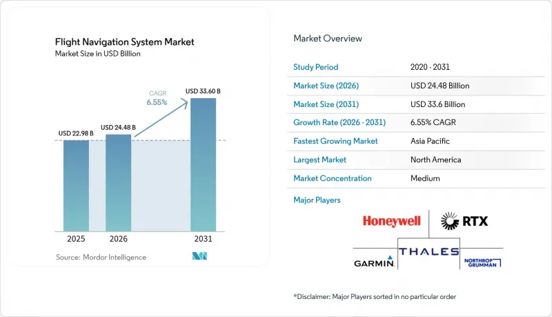
에 의하면, 비행 항법 시스템 시장 규모는 2025년에 229억 8,000만 달러, 2026년 244억 8,000만 달러에서 2031년까지 336억 달러에 이를 것으로 예측되며, 예측 기간(2026-2031년) CAGR은 6.55%를 기록할 전망입니다.
본 보고서는 통신 기술(무선, 위성, 하이브리드), 플랫폼(민간·상용 항공, 기타),비행 계기(자동 조종 장치, 고도계, 자이로스코프, 기타), 시스템 유형(레이더, 계기 착륙 장치, 기타), 구성 요소(하드웨어·소프트웨어), 지역(북미, 유럽, 기타)별로 분류되어 있습니다. 시장 예측은 금액(달러) 기준으로 제시되어 있습니다.
전 세계 비행 항법 시스템 시장 동향 및 인사이트
위성 기반 보강 시스템이 인프라 혁신을 주도
EGNOS는 2028년까지 5,100만 유로(6,001만 달러)의 연장 계약을 확보했으며, 이를 통해 유럽의 공항들은 새로운 지상 비콘을 설치하지 않고도 정밀 접근을 지원할 수 있게 되었습니다. 한국과 사하라 이남 아프리카의 유사한 프로그램도 이러한 성공을 재현하고 있으며, 항공사들은 구형 수신기를 폐기하고 SBAS 지원 하드웨어로 전환하고 있습니다. NextGen과 SESAR의 상호 운용성 관련 필수 조항은 장비 교체 주기를 가속화하고 전 세계적인 상호 운용성을 촉진하고 있습니다. 이로 인해 조종사의 훈련 시간과 비행 계획 수립 부담이 경감됩니다. 위성 신호가 ‘요구 항법 성능(RNP)’ 운항에 필요한 정밀도를 제공하기 때문에 항공사들은 지상국 유지보수 비용 절감을 환영하고 있습니다. 이러한 요인들이 결합되어 모든 기체 부문에서 업그레이드 수요가 증가하고 있습니다.
상용 항공기 함대의 확대가 비행 항법 시스템 수요를 견인
에어버스와 보잉의 미결 주문량은 2024년에 팬데믹 이전 수준으로 회복되었으며, 탈레스(Thales) 등 OEM 기업들은 비행 관리 및 항법 제품군을 위한 항공 전자 장비 수주액이 64억 유로(75억 4,000만 달러)에 달했다고 보고하고 있습니다. 항공사들은 연료 소비와 탄소 배출량을 줄여주는 연속 하강 및 동적 경로 설정 소프트웨어를 우선시하고 있습니다. 동시에, 더욱 전동화된 항공기 아키텍처로 인해 중량 감소를 위해 항법, 통신, 비행 제어 작업을 통합하는 통합 컴퓨팅 플랫폼의 도입이 진행되고 있습니다. 소프트웨어 정의형 내비게이션을 통해 무선으로 기능을 업데이트할 수 있게 되어, 긴 수명 기간 동안 자산 가치를 유지할 수 있습니다.
사이버 보안 위협이 항법 시스템의 취약점을 드러내다.
2024년에는 GPS 스푸핑 사례가 급증하여 분쟁 지역 상공을 비행하는 상업용 항공편에 혼란을 초래함에 따라, 항공사들은 여러 출처를 통한 위치 측정 백업 시스템을 탑재할 수밖에 없게 되었습니다. 이러한 이중화 조치는 비용과 인증 작업의 부담을 가중시킵니다. 현재 각 제조업체는 통신 장애 시에도 정확도를 유지하기 위해 양자 등급의 관성 센서를 탑재하고 있는 반면, 항공사는 비정상적인 위성 데이터를 감지하기 위한 실시간 모니터링 시스템에 투자하고 있습니다. 각국 정부는 주파수 모니터링 네트워크 구축으로 대응하고 있으나, 완전한 구축에는 아직 수년이 소요될 것으로 보입니다.
부문 분석
무선 링크는 확고히 자리 잡은 VHF 인프라와 전 세계 규제 요건으로 인해 2025년 매출의 39.10%를 차지했습니다. 그러나 하이브리드 GNSS-SBAS 솔루션은 연평균 성장률(CAGR) 8.78%로 다른 모든 기술을 앞지를 것으로 예상되며, 이는 지상 지원 설비가 필요 없는 정밀 접근 및 해양 영역 커버리지로 산업이 이동하고 있음을 보여줍니다. 하이브리드 솔루션을 위한 비행 항법 시스템 시장 규모는 승무원에게 실시간 교통 데이터를 제공하는 전용 ADS-B 위성 군을 발사하려는 위성 사업자들의 노력에 힘입어, 다른 어떤 통신 부문보다 빠르게 성장할 것으로 예측됩니다.
극지방 및 대양 횡단 노선에서는 위성 통신의 중요성이 높아지고 있는 반면, 소프트웨어 정의 무선(SDR)은 동적인 주파수 선택을 가능하게 하고 간섭을 줄여줍니다. 우주 기반 수신기와 지상 네트워크의 결합을 통해 항공사는 미래의 4차원 궤적 관리를 뒷받침할 견고한 통신 링크를 확보할 수 있습니다. 탈레스의 100기 위성으로 구성된 ADS-B 프로그램은 통합 모니터링 통신으로의 전환을 구현하고 있으며, 표준 항공전자 모듈을 활용하여 하드웨어 대수와 인증 비용을 절감하고 있습니다.
2025년에는 노후화된 협폭체 항공기의 교체와 여객 수요 회복을 배경으로, 민간 및 상업용 항공기가 비행 항법 시스템 시장의 40.80%를 차지했습니다. 각국이 외국 GNSS 신호의 영향을 받지 않는 자율적인 항법 능력 확립을 추구하는 가운데, 군용 항공기 부문은 연평균 성장률(CAGR) 9.05%라는 가장 높은 지출 성장률을 보이고 있습니다. 이러한 프로그램에서는 배선과 중량을 줄이기 위해 전자전 필터, 이중화된 관성 센서, AI를 활용한 임무 계획을 동일한 조종석 서버에 통합하는 경우가 빈번합니다.
세계 전투 항공 프로그램(GCAP)의 6세대 전투기 개념은 센서 융합과 적응형 항법이 미래의 공중 우세 확보 플랫폼의 기반이 될 것임을 보여줍니다. 동시에, 도심항공모빌리티(UAM)로 분류되는 eVTOL 에어 택시의 경우, 저고도 비행 채널용으로 설계된 인증된 안테나 및 다중 주파수 수신기의 사양 수립이 시작되고 있습니다. 이러한 다양성에 대한 수요로 인해, 전투기, 화물기, 비행 택시 등 기체 유형에 관계없이 최소한의 재인증만으로 재구성 가능한 플랫폼 독립형 항공전자 장비 세트의 수주 잔고가 유지되고 있습니다.
지역별 분석
북미는 꾸준한 NextGen 자금 지원, 견조한 비즈니스 제트기 생산, FAA의 파워 드리프트 항공기에 대한 적극적인 규제 제정에 힘입어 2025년에는 35.20%의 점유율을 유지하며 리더십을 지켰습니다. Q-143 및 T-467과 같은 지역 항법 경로의 추가는 여객 수가 회복되고 있는 가운데에도 항로 효율성이 지속적으로 향상되고 있음을 보여줍니다. 이 지역에서는 무선 소프트웨어 업데이트가 널리 보급되어 있으며, 디스패치 센터의 알고리즘에 직접 반영되는 클라우드 기반 항법 분석의 시험장으로서의 입지를 확고히 하고 있습니다.
아시아태평양은 가장 빠르게 성장하는 시장으로, 2021년부터 2031년까지 연평균 성장률(CAGR) 7.95%로 성장을 지속하고, 있습니다. 중국과 인도가 협폭기 수주를 주도하는 한편, 각 지역 정부는 위성을 이용한 항법 보강 시스템 및 무인 항공기 교통 관리(UTM) 체계에 자금을 투입하고 있습니다. 델리·NCR 지역에 신설된 탈레스(Thales)사의 MRO 시설과 태국 당국과의 UTM 로드맵에 관한 합의는 공급업체들이 현지 엔지니어링 거점으로 중심을 옮기고 있음을 보여주며, 이를 통해 현지 항공사의 인증 취득 기간을 단축할 수 있게 됩니다. 이러한 움직임에 따라 신규 단일 통로 항공기 기단에 하이브리드 GNSS-SBAS 수신기의 도입이 가속화되고 있습니다.
유럽에서는 SESAR가 주도하는 PBN(성능 기반 항법) 절차가 보급되고, 유럽항공안전청(EASA)이 도심항공모빌리티(UAM)의 항법 성능 기준을 규정하는 종합적인 VTOL 규정을 최종 확정함에 따라 견조한 성장세를 보이고 있습니다. EGNOS의 운영 기간을 2028년까지 연장함으로써 400개 이상의 공항에서 시정 불량 시 운항이 보장되며, 그 결과 SBAS 지원 비행 관리 컴퓨터 및 정밀 접근 표시 장치에 대한 수요가 유지되고 있습니다. 지속가능성 노력을 우선시하는 항공사들은 연속 하강 착륙을 가능하게 하는 비행 경로 예측 도구를 도입하고 있으며, 이를 통해 조종실 서버에서 예측 분석의 역할이 더욱 강화되고 있습니다.
기타 혜택
- 엑셀 형식 시장 예측(ME) 시트
- 3개월간의 애널리스트 지원
자주 묻는 질문
목차
제1장 서론
제2장 조사 방법
제3장 주요 요약
제4장 시장 구도
제5장 시장 규모와 성장 예측
제6장 경쟁 구도
제7장 시장 기회와 향후 전망
LSH 26.08.26According to Mordor Intelligence, the flight navigation system market size was valued at USD 22.98 billion in 2025 and estimated to grow from USD 24.48 billion in 2026 to reach USD 33.6 billion by 2031, at a CAGR of 6.55% during the forecast period (2026-2031).

This report is Segmented by Communication Technology (Radio, Satellite, Hybrid), Platform (Civil and Commercial Aviation, and More), Flight Instrument (Autopilot, Altimeter, Gyroscope, and More), System Type (Radars, Instrument Landing Systems, and More), Component (Hardware and Software), and Geography (North America, Europe, and More). The Market Forecasts are Provided in Terms of Value (USD).
Global Flight Navigation System Market Trends and Insights
Satellite-Based Augmentation Systems Drive Infrastructure Transformation
EGNOS secured a EUR 51 million (USD 60.01 million) extension through 2028, enabling European airports to support precision approaches without the need to install new ground beacons. Similar programs in Korea and sub-Saharan Africa have mirrored this success, prompting airlines to retire older receivers in favor of SBAS-ready hardware. Mandatory compatibility clauses within NextGen and SESAR accelerate equipment replacement cycles and promote global interoperability, which lowers pilot-training hours and flight-planning overheads. Airlines welcome lower ground-station maintenance costs because satellite signals deliver the required accuracy for Required Navigation Performance operations. These combined factors amplify upgrade demand across every fleet segment.
Commercial Fleet Expansion Fuels Navigation System Demand
Airbus and Boeing's order books returned to pre-pandemic levels in 2024, prompting OEMs like Thales to report EUR 6.4 billion (USD 7.54 billion) in avionics orders for flight management and navigation suites. Airlines prioritize continuous-descent and dynamic-routing software that cuts fuel burn and carbon penalties. Concurrently, more-electric aircraft architectures are inviting integrated computing platforms that consolidate navigation, communication, and flight-control tasks to reduce weight. Software-defined navigation unlocks over-the-air feature updates, protecting asset value across long service lives.
Cybersecurity Threats Expose Navigation Vulnerabilities
Confirmed GPS spoofing incidents rose sharply in 2024, disrupting commercial flights over conflict zones and compelling operators to fit multi-source positioning backups. Such redundancy raises costs and certification workloads. Manufacturers now embed quantum-grade inertial sensors to maintain accuracy during outages, while airlines invest in real-time monitoring to flag anomalous satellite data. Governments respond with spectrum-monitoring networks, but full deployment remains years away.
Other drivers and restraints analyzed in the detailed report include:
- Performance-Based Navigation Standards Reshape Operational Requirements
- UAV Navigation Reliability Drives Technology Innovation
- 5G Spectrum Interference Challenges Radar Altimeter Operations
For complete list of drivers and restraints, kindly check the Table Of Contents.
Segment Analysis
Radio links accounted for 39.10% of 2025 revenue, owing to entrenched VHF infrastructure and worldwide regulatory mandates. Yet, hybrid GNSS-SBAS solutions are set to outpace all other technologies with an 8.78% CAGR, illustrating the industry's shift toward precision approaches and oceanic coverage without ground aids. The flight navigation system market size for hybrid solutions is projected to grow faster than any other communication category, supported by satellite operators launching dedicated ADS-B constellations that feed real-time traffic data to crews.
Satellite communication gains relevance on polar and transoceanic routes, while software-defined radios enable dynamic frequency selection to mitigate interference. The combination of space-based receivers and ground networks equips airlines with resilient links that underpin future four-dimensional trajectory management exercises. Thales' 100-satellite ADS-B program exemplifies this migration toward integrated surveillance and communications, reducing hardware counts and certification costs by utilizing standard avionics modules.
Civil and commercial fleets controlled 40.80% of the flight navigation system market share in 2025, driven by the replacement of aging narrowbody aircraft and the rebound in passenger demand. Militaries drive the highest spending velocity with a 9.05% CAGR as nations pursue sovereign navigation capacity immune to foreign GNSS signals. These programs frequently bundle electronic-warfare filters, redundant inertial sensors, and AI-assisted mission planning in the same cockpit server to cut wiring and weight.
The Global Combat Air Programme's (GCAP's) sixth-generation fighter concept demonstrates that sensor fusion and adaptive navigation will underpin future air superiority platforms. At the same time, eVTOL air taxis, categorized under urban air mobility, begin to specify certified antennas and multi-frequency receivers designed for low-altitude corridors. This demand for diversity sustains backlog for platform-agnostic avionics suites that can be repackaged across fighters, freighters, and flying taxis with minimal requalification.
Complete Report Scope:
- By Communication Technology
- Radio
- Satellite
- Hybrid (GNSS+SBAS)
- By Platform
- Civil and Commercial Aviation
- Business and General Aviation
- Military Aviation
- UAV/eVTOL
- By Flight Instrument
- Autopilot
- Altimeter
- Gyroscope
- Attitude Heading Reference System (AHRS)
- Sensors (IMU, Air-data, etc.)
- Magnetic Compass
- By System Type
- Radars
- Instrument Landing Systems (ILS)
- Inertial Navigation Systems (INS)
- Collision Avoidance Systems (CAS)
- GNSS/VOR-DME
- Other Systems
- By Component
- Hardware
- Software
- By Geography
- North America
- United States
- Canada
- Mexico
- Europe
- United Kingdom
- Germany
- France
- Rest of Europe
- Asia-Pacific
- China
- Japan
- India
- South Korea
- Rest of Asia-Pacific
- South America
- Brazil
- Argentina
- Rest of South America
- Middle East and Africa
- Middle East
- Saudi Arabia
- UAE
- Turkey
- Rest of Middle East
- Africa
- South Africa
- Rest of Africa
- Middle East
- North America
Geography Analysis
North America kept its leadership with a 35.20% share in 2025, underpinned by steady NextGen funding, strong business-jet production, and the FAA's proactive rulemaking on powered-lift aircraft. Area navigation route additions such as Q-143 and T-467 show that en-route efficiency upgrades persist even as passenger numbers rebound. The region's broad adoption of over-the-air software updates positions it as a proving ground for cloud-based navigation analytics that feed directly into dispatch-center algorithms.
The Asia-Pacific region is the fastest-growing arena, with a 7.95% CAGR from 2021 to 2031. China and India dominate the order books for narrowbody jets, while regional governments allocate capital toward satellite-based augmentation and unmanned traffic management frameworks. Thales's new MRO facility in the Delhi-NCR region and its UTM roadmap agreement with Thai authorities illustrate a supplier's pivot toward local engineering hubs, which can reduce time-to-certification for indigenous carriers. These moves accelerate the adoption of hybrid GNSS-SBAS receivers across new single-aisle fleets.
Europe registers solid gains as SESAR-driven PBN procedures proliferate, and the European Union Aviation Safety Agency finalizes comprehensive VTOL regulations that establish navigation performance baselines for urban air mobility. The EGNOS service life extension to 2028 safeguards low-visibility operations for more than 400 airports, thereby sustaining demand for SBAS-capable flight management computers and precision approach displays. Sustainability priorities are driving airlines to adopt trajectory prediction tools that enable continuous-descent arrivals, thereby reinforcing the role of predictive analytics within cockpit servers.
- Honeywell International Inc.
- Collins Aerospace (RTX Corporation)
- Thales Group
- Garmin Ltd.
- Northrop Grumman Corporation
- Safran SA
- L3Harris Technologies Inc.
- BAE Systems plc
- General Electric Company
- Universal Avionics Systems Corporation (Elbit Systems Ltd.)
- Leonardo S.p.A
- Moog Inc.
- Avidyne Corporation
- Saab AB
- The Boeing Company
Additional Benefits:
- The market estimate (ME) sheet in Excel format
- 3 months of analyst support
TABLE OF CONTENTS
1 INTRODUCTION
- 1.1 Study Assumptions and Market Definition
- 1.2 Scope of the Study
2 RESEARCH METHODOLOGY
3 EXECUTIVE SUMMARY
4 MARKET LANDSCAPE
- 4.1 Market Overview
- 4.2 Market Drivers
- 4.2.1 Satellite-based augmentation (SBAS) and NextGen/SESAR mandates
- 4.2.2 Rising global commercial aircraft fleet
- 4.2.3 Shift to performance-based navigation (PBN) standards
- 4.2.4 Growing demand for UAV and long-range UAS navigation reliability
- 4.2.5 Urban-air-mobility corridor integration needs
- 4.2.6 AI-driven sensor-fusion redundancy for zero-fail cockpits
- 4.3 Market Restraints
- 4.3.1 High upgrade and certification costs
- 4.3.2 Cyber-jamming and spoofing vulnerabilities
- 4.3.3 5G spectrum re-allocation crowding navigation bands
- 4.3.4 Rare-earth magnet shortages for MEMS gyros
- 4.4 Value Chain Analysis
- 4.5 Regulatory Landscape
- 4.6 Technological Outlook
- 4.7 Porter's Five Forces Analysis
- 4.7.1 Bargaining Power of Buyers/Consumers
- 4.7.2 Bargaining Power of Suppliers
- 4.7.3 Threat of New Entrants
- 4.7.4 Threat of Substitute Products
- 4.7.5 Intensity of Competitive Rivalry
5 MARKET SIZE AND GROWTH FORECASTS
- 5.1 By Communication Technology
- 5.1.1 Radio
- 5.1.2 Satellite
- 5.1.3 Hybrid (GNSS+SBAS)
- 5.2 By Platform
- 5.2.1 Civil and Commercial Aviation
- 5.2.2 Business and General Aviation
- 5.2.3 Military Aviation
- 5.2.4 UAV/eVTOL
- 5.3 By Flight Instrument
- 5.3.1 Autopilot
- 5.3.2 Altimeter
- 5.3.3 Gyroscope
- 5.3.4 Attitude Heading Reference System (AHRS)
- 5.3.5 Sensors (IMU, Air-data, etc.)
- 5.3.6 Magnetic Compass
- 5.4 By System Type
- 5.4.1 Radars
- 5.4.2 Instrument Landing Systems (ILS)
- 5.4.3 Inertial Navigation Systems (INS)
- 5.4.4 Collision Avoidance Systems (CAS)
- 5.4.5 GNSS/VOR-DME
- 5.4.6 Other Systems
- 5.5 By Component
- 5.5.1 Hardware
- 5.5.2 Software
- 5.6 By Geography
- 5.6.1 North America
- 5.6.1.1 United States
- 5.6.1.2 Canada
- 5.6.1.3 Mexico
- 5.6.2 Europe
- 5.6.2.1 United Kingdom
- 5.6.2.2 Germany
- 5.6.2.3 France
- 5.6.2.4 Rest of Europe
- 5.6.3 Asia-Pacific
- 5.6.3.1 China
- 5.6.3.2 Japan
- 5.6.3.3 India
- 5.6.3.4 South Korea
- 5.6.3.5 Rest of Asia-Pacific
- 5.6.4 South America
- 5.6.4.1 Brazil
- 5.6.4.2 Argentina
- 5.6.4.3 Rest of South America
- 5.6.5 Middle East and Africa
- 5.6.5.1 Middle East
- 5.6.5.1.1 Saudi Arabia
- 5.6.5.1.2 UAE
- 5.6.5.1.3 Turkey
- 5.6.5.1.4 Rest of Middle East
- 5.6.5.2 Africa
- 5.6.5.2.1 South Africa
- 5.6.5.2.2 Rest of Africa
- 5.6.5.1 Middle East
- 5.6.1 North America
6 COMPETITIVE LANDSCAPE
- 6.1 Market Concentration
- 6.2 Strategic Moves and Developments
- 6.3 Market Share Analysis
- 6.4 Company Profiles (includes Global level Overview, Market level overview, Core Segments, Financials as available, Strategic Information, Market Rank/Share, Products and Services, Recent Developments)
- 6.4.1 Honeywell International Inc.
- 6.4.2 Collins Aerospace (RTX Corporation)
- 6.4.3 Thales Group
- 6.4.4 Garmin Ltd.
- 6.4.5 Northrop Grumman Corporation
- 6.4.6 Safran SA
- 6.4.7 L3Harris Technologies Inc.
- 6.4.8 BAE Systems plc
- 6.4.9 General Electric Company
- 6.4.10 Universal Avionics Systems Corporation (Elbit Systems Ltd.)
- 6.4.11 Leonardo S.p.A
- 6.4.12 Moog Inc.
- 6.4.13 Avidyne Corporation
- 6.4.14 Saab AB
- 6.4.15 The Boeing Company
7 MARKET OPPORTUNITIES AND FUTURE OUTLOOK
- 7.1 White-space and Unmet-need Assessment


