

|
시장보고서
상품코드
2114479
고고도 의사 위성 : 시장 점유율 분석, 업계 동향 및 통계, 성장 예측(2026-2031년)High Altitude Pseudo Satellites - Market Share Analysis, Industry Trends & Statistics, Growth Forecasts (2026 - 2031) |
||||||
 Mordor Intelligence
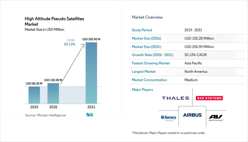
Mordor Intelligence에 의하면, 고고도 의사 위성 시장 규모는 2025년 8,530만 달러로 평가되었습니다. 2026년에는 1억 228만 달러로 확대되어 2026년부터 2031년에 걸쳐 CAGR 19.34%로 성장을 지속하여, 2031년까지 2억 4,756만 달러에 이를 것으로 예측됩니다.
본 보고서는 기술별(성층권 풍선, 무인 항공기, 비행선), 용도별(통신·연결성, ISR 등), 최종 사용자별(정부·국방, 상업, 조사), 전원별(태양광 발전 등), 지역별(북미, 유럽 등)로 분류되어 있습니다. 시장 예측은 금액(달러) 기준으로 제시되어 있습니다.
세계의 고고도 의사 위성 시장 동향 및 인사이트
5G/6G NTN의 급속한 확산
통신 사업자들은 기존 통신탑의 경제성이 부족한 지역으로 5G 통신 범위를 확대하기 위해 성층권 플랫폼을 비지상 네트워크에 통합하고 있습니다. Space Compass사는 2025년 3월, 케냐에서 ‘Aalto Zephyr’를 활용하여 반경 140km 범위 내 1,000명의 사용자에게 서비스를 제공함으로써 해당 서비스의 상업적 실현 가능성을 입증했습니다. HAPSMobile사는 2024년 5월에 38GHz mm파 연결을 실증했으며, 2026년 말까지 일본에서 상용 서비스를 시작하는 것을 목표로 하고 있으며, 고고도 의사 위성(HAPS) 시장을 6G의 조기 통합을 위한 기반으로 삼고 있습니다. 3GPP 릴리스 18에서는 HAPS를 네트워크 노드로 취급하고 있으며, 벤더는 기존 공급망을 통해 듀얼 모드 무선기를 출하할 수 있게 되었습니다. 이러한 움직임으로 인해 통합 위험이 완화되고, 장비 인증이 가속화되며, 지방 및 해상 지역의 커버리지를 우선시하는 통신 사업자에게는 수익 예측의 확고한 기반이 마련됩니다.
확대되는 ISR 및 지속적 감시에 대한 지출
각국의 국방부는 수개월간 공중에 체류할 수 있고 유인 항공기보다 비용이 저렴한 성층권 플랫폼으로 감시 예산을 전환하고 있습니다. 미 육군은 유인 ISR 비행 비용이 시간당 1만 달러를 초과함에 따라 무인 대체 수단에 대한 평가를 진행하고 있습니다. 한편, BAE 시스템즈의 PHASA-35와 같은 플랫폼은 2024년 12월, 탑재 하중 용량을 2배로 늘린 상태에서 성층권 내 24시간 체공 능력을 입증했습니다. Sceye사의 NASA와의 제휴는 산불 추적 및 메탄 감지 분야에서 민간 및 정부 기관의 채택 사례로, 고고도 가상 위성 시장의 고객 기반을 더욱 확대되고 있습니다. 급유가 필요 없는 지속적 배치는 자산이 연중 내내 지정된 위치에 머물며 상황 인식을 향상시키는 새로운 운영 개념의 토대가 되고 있습니다.
비행 시간당 높은 자본 지출(CAPEX) 및 유지비
단일 플랫폼을 확보하는 데 1,000만-5,000만 달러가 필요하며, 국가 지원이나 풍부한 자금원을 갖추지 못한 사업자에게는 장벽이 됩니다. 몇 달에 걸친 임무에서는 직접 운영비(OPEX)로 216만-1,080만 달러가 소요되며, 회수 주기마다 제어 하강, 기체 검사, 연료 보급을 위해 추가로 100만 달러의 비용이 발생할 수 있습니다. 2차 시장이 제한적이어서 감가상각이 고정되는 반면, 급속한 기술 발전으로 인해 노후화 위험이 높아지고 있습니다. 이러한 경제적 요인으로 인해 모듈식 설계를 통해 단가가 낮아질 때까지는 고고도 가상 위성 시장 진출이 자금력이 있는 통신 사업자나 국방 기관으로 한정될 것입니다.
부문별 분석
고고도 유사위성 시장에서 2025년 매출의 59.85%를 무인 항공기가 차지했습니다. 이는 150파운드의 탑재량을 운반하고 수개월간 비행이 가능한, 검증된 태양전지·전기 구동 설계 덕분입니다. 한편, 비행선은 회수 없이 1년 동안 임무를 수행할 수 있게 해주는 헬륨 유지 기능을 갖춘 선체 소재에 힘입어 연평균 성장률(CAGR) 25.45%로 가장 빠르게 성장하는 카테고리로 부상하고 있습니다. 풍선은 30일 미만의 과학 연구 캠페인에서 여전히 저비용 옵션으로 자리 잡고 있습니다. 에어로바이로먼트(Aerobirement)사의 ‘Horus A’는 2024년 10월 FAA 인증을 획득하며, 상업용 ISR(정보·감시·정찰) 계약으로 향하는 명확한 길을 열었습니다. 한편, Sceye사의 270피트 비행선은 10,000 km²가 넘는 정적 영역을 확보하며 통신 백홀 시장을 목표로 하고 있습니다.
비행선은 부력을 이용하여 거의 정지한 상태로 호버링할 수 있어 추진 에너지를 최소화할 수 있습니다. 이는 안정적인 방향성이 요구되는 영상 감시나 백홀 용도에서 장점이 됩니다. 반면, 무인항공기(UAV)는 프로펠러에 의한 지속적인 추력을 이용하기 때문에 재해나 계절적 요인으로 인해 수요가 변동할 때 기동적으로 위치를 변경하기 위해 더 많은 에너지를 소비할 수밖에 없습니다. 풍선은 신속한 발사가 필요한 경우나 위치 유지 능력 및 제어 능력이 부족한 대학 등에서 활용되고 있습니다. 이를 종합해 보면, 이러한 상충 관계로 인해 고고도 의사 위성 시장 내의 수익 채널은 다양화되고 있으며, 각 기술은 특정 체공 시간, 탑재 하중 및 설비 투자(Capex)의 허용 범위에 대응하고 있습니다.
통신 및 연결 플랫폼은 2025년 고고도 의사 위성 시장 매출의 42.55%를 차지했으며, 이 비율은 연평균 성장률(CAGR) 24.40%로 확대될 것으로 예측됩니다. 이는 모바일 네트워크 사업자가 지방의 5G 구축에 HAPS 노드를 통합함으로써 인구 밀도가 낮은 지역에서 고가의 통신 타워 네트워크에 대한 필요성이 줄어들기 때문입니다. 그 다음으로는 정보·감시·정찰(ISR) 기능이 꼽힙니다. 군 당국은 유인 정찰기에서 급유 없이 수 주간 공중에 머물 수 있고 상시 감시가 가능한 성층권 자산으로 전환하고 있습니다. 또한, NASA와 USGS가 성층권 비행선에서 메탄 및 산불 데이터를 수집하고 있어 지구관측 및 기후 모니터링 수요가 증가하고 있으며, 이로 인해 민간 분야의 수익원이 창출되고 사업자의 수입원이 다양화되고 있습니다. 항법 및 과학 임무는 여전히 틈새 분야이지만, 비행 시간을 공유함으로써 여러 유형의 페이로드에 플랫폼 비용을 분산시키고 높은 가동률을 유지할 수 있다는 장점이 있습니다.
2025년 3월 실시된 ‘제퍼(Zephyr)’ 실증 시험에서는 HAPS 플랫폼 1대로 일반적으로 약 50기의 매크로 타워가 커버하는 지역을 포괄할 수 있음이 입증되어, 지방 통신 사업자에게 설득력 있는 경제적 이점이 뒷받침되었습니다. BAE 시스템즈는 자사의 ‘PHASA-35’에 합성개구레이더를 통합하여, 유인 항공기 비용의 몇 분의 일 수준에서 국경 및 해상 감시에 대한 ISR(정보·감시·정찰)의 가능성을 입증했습니다. Sceye사의 민간 계약은 환경 감지를 통한 수익이 통신 페이로드 비용을 상쇄하여 복합적인 비즈니스 모델을 창출할 수 있음을 보여줍니다. 광대역 통신과 고해상도 영상 촬영을 결합한 듀얼 페이로드 임무가 보편화됨에 따라, 사업자들은 비행 가동률을 높이고 투자 회수 기간을 단축하고 있습니다. 이러한 사업 다각화를 통해 특정 고객층에 대한 의존도가 낮아지고, 현금 흐름이 강화되며, 고고도 가상 위성(HAPS)의 잠재적 시장 규모가 확대됩니다.
지역별 분석
북미는 연방항공청(FAA)의 고고도 비행 경로, 연방통신위원회(FCC)의 47GHz 대역 주파수 할당, 그리고 다년 계약을 뒷받침하는 국방부(DoD)의 ISR 예산에 힘입어 2025년 매출의 35.50%를 차지했습니다. 에어로바이러먼트(Aeroviroment)사의 ‘Horus A’ 인증 획득은 명확한 규제가 상용화까지의 기간을 단축할 수 있음을 보여주는 반면, NASA 및 미국 지질조사국(USGS)과의 제휴는 현금 흐름의 위험을 완화하는 핵심 파트너로서의 역할을 수행하고 있습니다. 벤처 캐피털과 성숙한 항공우주 공급망 덕분에 초기 생산은 미국에 집중되어 있으며, 이는 규모의 경제를 촉진하여 단가 절감과 고고도 가상위성 시장 전체의 확장으로 이어지고 있습니다.
아시아태평양은 2031년까지 연평균 성장률(CAGR) 25.70%라는 가장 빠른 속도로 성장하고 있으며, 그 원동력은 일본의 상업 발사 계획, 인도의 국경 감시 시범 사업, 그리고 중국의 근우주선 프로그램입니다. 소프트뱅크가 2026년 하반기에 시작할 서비스는 광범위한 통신 커버리지의 공백을 메우고, 지상 셀과 성층권 셀 간의 원활한 핸드오버를 보장할 것입니다. 케냐에서의 개념 검증은 동남아시아 및 태평양 섬 지역의 신흥 경제국들에게 모범 사례가 되고 있으며, HAPS가 모바일 머니 생태계와 전자정부 서비스를 어떻게 실현할 수 있는지 보여주고 있습니다. 호주와 한국의 지역 규제 당국이 주파수 대역 해방을 검토함에 따라, 대상인 고고도 가상 위성 시장은 더욱 확대되고 있습니다.
유럽은 고고도 의사 위성 시장 점유율을 차지하고 있지만, 2026년에 유럽항공안전청(EASA)의 운영 규정이 확정될 때까지는 규제 측면에서 지연을 겪고 있습니다. BAE 시스템즈의 ‘PHASA-35’와 독일 항공우주센터(DLR)의 ‘HAP-alpha’ 비행 시험은 승인 절차가 지연되고 있음에도 불구하고 기술적 역량을 입증하고 있습니다. 중동의 사업자들은 관대한 공역 규제 하에서 유전 통신 인프라로 HAPS를 도입하고 있지만, 아프리카와 남미에서는 아직 초기 단계에 있으며, 아마존과 사헬 지역에서의 실증 실험에 중점을 두고 있습니다. 현지 규제 당국이 ICAO의 템플릿을 채택하면 도입이 가속화되어 전 세계 고고도 의사 위성(HAPS) 시장의 전개 범위가 다양해질 것으로 예측됩니다.
기타 혜택 :
- 엑셀 형식 시장 예측(ME) 시트
- 3개월간의 애널리스트 지원
자주 묻는 질문
목차
제1장 서론
제2장 조사 방법
제3장 주요 요약
제4장 시장 구도
제5장 시장 규모 및 성장 예측
제6장 경쟁 구도
제7장 시장 기회 및 향후 전망
KTH 26.08.28According to Mordor Intelligence, the high-altitude pseudo-satellites market size is expected to grow from USD 85.30 million in 2025 to USD 102.28 million in 2026 and is forecasted to reach USD 247.56 million by 2031 at a 19.34% CAGR over 2026-2031.
This report is Segmented by Technology (Stratospheric Balloons, Unmanned Aerial Vehicles, Airships), Application (Communication and Connectivity, ISR, and More), End-User (Government and Defense, and Commercial, Research), Power Source (Solar-Electric, and More), and Geography (North America, Europe, and More). Market Forecasts are Provided in Terms of Value (USD).
Global High Altitude Pseudo Satellites Market Trends and Insights
Rapid 5G/6G NTN Roll-Outs
Telecom operators integrate stratospheric platforms into non-terrestrial networks to extend 5G coverage into areas where traditional tower economics are insufficient. Space Compass utilized an Aalto Zephyr to serve 1,000 users across a 140 km radius in Kenya in March 2025, confirming the commercial viability of its service. HAPSMobile demonstrated 38 GHz millimeter-wave connectivity in May 2024 and targets commercial service in Japan by late 2026, positioning the high-altitude pseudo-satellite (HAPS) market for early 6G integration. 3GPP Release 18 treats HAPS as a network node, allowing vendors to ship dual-mode radios through established supply chains. These moves reduce integration risk, accelerate equipment certification, and anchor revenue projections for operators that prioritize rural and maritime coverage.
Growing ISR and Persistent Surveillance Outlays
Defense ministries are redirecting surveillance budgets toward stratospheric platforms that can loiter for months and cost less than crewed aircraft. The United States Army evaluates unmanned alternatives because manned ISR flights exceed USD 10,000 per hour, while platforms like BAE Systems' PHASA-35 demonstrated 24-hour stratospheric endurance in December 2024 with a doubled payload capacity. Sceye's NASA partnership exemplifies civil-government adoption for wildfire tracking and methane detection, further broadening the high-altitude pseudo-satellite (HAPS) market's customer base. Persistent presence without refueling underpins new concepts of operation where assets remain on-station year-round, improving situational awareness.
High CAPEX and Maintenance Cost per Flight-Hour
Acquiring a single platform demands USD 10 million-USD 50 million, a hurdle for operators without sovereign backing or deep capital pools. Multi-month missions consume USD 2.16 million to USD 10.8 million in direct OPEX, and each retrieval cycle can cost an additional USD 1 million for controlled descent, hull inspection, and gas replenishment. Limited secondary markets lock in depreciation, while rapid technology advances threaten obsolescence. These economics narrow the addressable high-altitude pseudo-satellites (HAPS) market to well-funded telecom carriers and defense agencies until modular designs drive down unit prices.
Other drivers and restraints analyzed in the detailed report include:
- Cost Advantage over LEO Constellations
- Advances in Ultra-Light Solar/Battery Systems
- Spectrum and Airspace Regulatory Complexity
For complete list of drivers and restraints, kindly check the Table Of Contents.
Segment Analysis
Unmanned aerial vehicles controlled 59.85% of the 2025 revenue within the high-altitude pseudo-satellite market, due to their proven solar-electric designs capable of carrying 150-lb payloads and multi-month flights. Airships emerge as the fastest-growing class at a 25.45% CAGR, propelled by hull fabrics that hold helium for year-long missions without retrieval. Balloons remain the low-cost choice for sub-30-day scientific campaigns. AeroVironment's Horus A gained FAA certification in October 2024, demonstrating a clear path to commercial ISR contracting, whereas Sceye's 270-ft airship targets telecom backhaul with a stationary footprint over 10,000 km2.
Airships leverage buoyancy to hover almost motionless, consuming minimal propulsion energy, which is an advantage for video surveillance and backhaul applications that require stable pointing. UAVs utilize continuous propeller thrust, sacrificing higher energy needs for agile repositioning when disasters or seasonal events alter demand. Balloons serve universities needing rapid launches but lack station-keeping and controllability. Taken together, these trade-offs diversify revenue channels within the high-altitude pseudo-satellite (HAPS) market, with each technology catering to specific endurance, payload, and capital expenditure (Capex) tolerances.
Communication and connectivity platforms captured 42.55% of the 2025 revenue in the high-altitude pseudo-satellites (HAPS) market, and this portion is projected to grow at a 24.40% CAGR as mobile network operators embed HAPS nodes into rural 5G rollouts, reducing the need for expensive tower grids in sparsely populated areas. Intelligence, surveillance, and reconnaissance (ISR) capabilities follow, with militaries shifting from crewed patrol aircraft to persistent "eyes-in-the-sky" stratospheric assets that can loiter for weeks without refueling. Earth-observation and climate-monitoring demand is rising because NASA and USGS procure methane and wildfire data from stratospheric airships, creating a civilian revenue stream that diversifies operator income. Navigation and scientific missions remain niche but benefit from shared airtime, amortizing platform costs across multiple payload types to maintain high utilization.
The March 2025 Zephyr field trial demonstrated that one HAPS platform can cover the area typically served by approximately 50 macro towers, validating a compelling economic lever for rural telecom carriers. BAE Systems integrated a synthetic-aperture radar into its PHASA-35, demonstrating the ISR potential for border and maritime surveillance at a fraction of the cost of crewed aircraft. Sceye's civil contracts demonstrate how environmental sensing revenues can subsidize connectivity payloads, creating blended business models. As dual-payload missions that pair broadband links with high-resolution imagery become common, operators increase flight utilization and shorten payback periods. This diversification reduces reliance on any single customer class, strengthens cash flows, and broadens the total addressable market for high-altitude pseudo-satellites (HAPS).
Complete Report Scope:
- By Technology
- Stratospheric Balloons
- Unmanned Aerial Vehicles
- Airships
- By Application
- Communication and Connectivity
- Intelligence, Surveillance and Reconnaissance (ISR)
- Earth Observation and Climate Monitoring
- Navigation and Positioning
- Scientific and Research Missions
- By End-User
- Government and Defense
- Commercial Enterprises
- Research Institutions
- By Power Source
- Solar-Electric
- Hybrid Hydrogen-Fuel-Cell
- Battery
- By Geography
- North America
- United States
- Canada
- Mexico
- Europe
- United Kingdom
- France
- Germany
- Italy
- Rest of Europe
- Asia-Pacific
- China
- India
- Japan
- Australia
- South Korea
- Rest of Asia-Pacific
- South America
- Brazil
- Rest of South America
- Middle East and Africa
- Middle East
- Saudi Arabia
- United Arab Emirates
- Turkey
- Rest of Middle East
- Africa
- South Africa
- Rest of Africa
- Middle East
- North America
Geography Analysis
North America captured 35.50% of the 2025 revenue, buoyed by the Federal Aviation Administration's (FAA) high-altitude corridors, the Federal Communications Commission's 47 GHz spectrum allocations, and the Department of Defense's ISR budgets, which underwrite multi-year contracts. AeroVironment's Horus A certification demonstrates that clear rules can shorten commercialization timelines, while partnerships with NASA and the USGS act as anchor tenants that de-risk cash flows. Venture capital and mature aerospace supply chains concentrate early production in the United States, fostering economies of scale that lower unit cost and expand the overall high-altitude pseudo-satellites (HAPS) market.
Asia-Pacific advances fastest at 25.70% CAGR through 2031, propelled by Japan's scheduled commercial launches, India's border-surveillance pilots, and China's near-space vehicle programs. SoftBank's late-2026 service will bridge significant coverage gaps and ensure seamless handoffs between terrestrial and stratospheric cells. Kenya's proof-of-concept offers a template for emerging economies in Southeast Asia and Pacific islands, illustrating how HAPS enables mobile-money ecosystems and e-government services. Regional regulators in Australia and South Korea, as they evaluate spectrum releases, further widen the addressable high-altitude pseudo-satellite (HAPS) market.
Europe holds a mid-tier share but faces a regulatory lag until EASA's operational rules are finalized in 2026. BAE Systems' PHASA-35 and DLR's HAP-alpha flights demonstrate technical competence despite slower approvals. Middle Eastern operators deploy HAPS for oil-field connectivity under permissive airspace regimes, while Africa and South America remain embryonic, focusing on pilots in the Amazon and Sahel regions. Adoption is expected to accelerate once local regulators adopt ICAO templates, diversifying the global high-altitude pseudo-satellites (HAPS) market footprint.
- AeroVironment, Inc.
- Airbus SE
- BAE Systems plc
- Thales Group
- Aerostar LLC
- Mira Aerospace Ltd.
- Sceye Inc.
- Stratosyst s.r.o.
- Involve Space S.R.L.
- HAPSMobile Inc. (SoftBank Corp.)
- Aurora Flight Sciences (The Boeing Company)
- Avealto Limited
- Zero 2 Infinity, S.L.
- Kea Aerospace Limited
- Stratospheric Platforms Ltd.
- Atlas LTA Advanced Technology, Ltd.
- Sierra Nevada Company, LLC.
- Maraal Aerospace Pvt. Ltd.
- Voltitude Ltd.
Additional Benefits:
- The market estimate (ME) sheet in Excel format
- 3 months of analyst support
TABLE OF CONTENTS
1 INTRODUCTION
- 1.1 Study Assumptions
- 1.2 Scope of the Study
2 RESEARCH METHODOLOGY
3 EXECUTIVE SUMMARY
4 MARKET LANDSCAPE
- 4.1 Market Overview
- 4.2 Market Drivers
- 4.2.1 Rapid 5G/6G NTN roll-outs
- 4.2.2 Growing ISR and persistent surveillance outlays
- 4.2.3 Cost advantage over LEO constellations
- 4.2.4 Advances in ultra-light solar/battery systems
- 4.2.5 Carbon-reduction mandates favoring low-emission rural backhaul
- 4.2.6 Stratospheric air-traffic corridors opened by regulators
- 4.3 Market Restraints
- 4.3.1 High CAPEX and maintenance cost per flight-hour
- 4.3.2 Spectrum and airspace regulatory complexity
- 4.3.3 Stratospheric wind-shear unpredictability
- 4.3.4 Insurance and liability gaps for more than 30-day unmanned sorties
- 4.4 Value Chain Analysis
- 4.5 Regulatory Landscape
- 4.6 Technological Outlook
- 4.7 Portera€(TM)s Five Forces Analysis
- 4.7.1 Bargaining Power of Suppliers
- 4.7.2 Bargaining Power of Buyers
- 4.7.3 Threat of New Entrants
- 4.7.4 Threat of Substitutes
- 4.7.5 Intensity of Competitive Rivalry
5 MARKET SIZE AND GROWTH FORECASTS (VALUE)
- 5.1 By Technology
- 5.1.1 Stratospheric Balloons
- 5.1.2 Unmanned Aerial Vehicles
- 5.1.3 Airships
- 5.2 By Application
- 5.2.1 Communication and Connectivity
- 5.2.2 Intelligence, Surveillance and Reconnaissance (ISR)
- 5.2.3 Earth Observation and Climate Monitoring
- 5.2.4 Navigation and Positioning
- 5.2.5 Scientific and Research Missions
- 5.3 By End-User
- 5.3.1 Government and Defense
- 5.3.2 Commercial Enterprises
- 5.3.3 Research Institutions
- 5.4 By Power Source
- 5.4.1 Solar-Electric
- 5.4.2 Hybrid Hydrogen-Fuel-Cell
- 5.4.3 Battery
- 5.5 By Geography
- 5.5.1 North America
- 5.5.1.1 United States
- 5.5.1.2 Canada
- 5.5.1.3 Mexico
- 5.5.2 Europe
- 5.5.2.1 United Kingdom
- 5.5.2.2 France
- 5.5.2.3 Germany
- 5.5.2.4 Italy
- 5.5.2.5 Rest of Europe
- 5.5.3 Asia-Pacific
- 5.5.3.1 China
- 5.5.3.2 India
- 5.5.3.3 Japan
- 5.5.3.4 Australia
- 5.5.3.5 South Korea
- 5.5.3.6 Rest of Asia-Pacific
- 5.5.4 South America
- 5.5.4.1 Brazil
- 5.5.4.2 Rest of South America
- 5.5.5 Middle East and Africa
- 5.5.5.1 Middle East
- 5.5.5.1.1 Saudi Arabia
- 5.5.5.1.2 United Arab Emirates
- 5.5.5.1.3 Turkey
- 5.5.5.1.4 Rest of Middle East
- 5.5.5.2 Africa
- 5.5.5.2.1 South Africa
- 5.5.5.2.2 Rest of Africa
- 5.5.5.1 Middle East
- 5.5.1 North America
6 COMPETITIVE LANDSCAPE
- 6.1 Market Concentration
- 6.2 Strategic Moves
- 6.3 Market Share Analysis
- 6.4 Company Profiles (includes Global-level Overview, Market-level Overview, Core Segments, Financials, Strategic Information, Market Rank / Share, Products and Services, Recent Developments)
- 6.4.1 AeroVironment, Inc.
- 6.4.2 Airbus SE
- 6.4.3 BAE Systems plc
- 6.4.4 Thales Group
- 6.4.5 Aerostar LLC
- 6.4.6 Mira Aerospace Ltd.
- 6.4.7 Sceye Inc.
- 6.4.8 Stratosyst s.r.o.
- 6.4.9 Involve Space S.R.L.
- 6.4.10 HAPSMobile Inc. (SoftBank Corp.)
- 6.4.11 Aurora Flight Sciences (The Boeing Company)
- 6.4.12 Avealto Limited
- 6.4.13 Zero 2 Infinity, S.L.
- 6.4.14 Kea Aerospace Limited
- 6.4.15 Stratospheric Platforms Ltd.
- 6.4.16 Atlas LTA Advanced Technology, Ltd.
- 6.4.17 Sierra Nevada Company, LLC.
- 6.4.18 Maraal Aerospace Pvt. Ltd.
- 6.4.19 Voltitude Ltd.
7 MARKET OPPORTUNITIES AND FUTURE OUTLOOK
- 7.1 White-space and Unmet-Need Assessment


