

|
시장보고서
상품코드
2123345
항공 촬영 시장 : 점유율 분석, 업계 동향과 통계, 성장 예측(2026-2031년)Aerial Imaging - Market Share Analysis, Industry Trends & Statistics, Growth Forecasts (2026 - 2031) |
||||||
 Mordor Intelligence
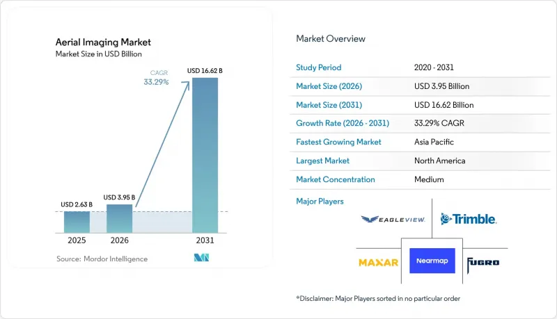
Mordor Intelligence에 의하면, 항공 촬영 시장 규모는 2025년 26억 3,000만 달러, 2026년 39억 5,000만 달러에서 확대해, 2031년까지 166억 2,000만 달러에 이를 것으로 예측되며, 2026년부터 2031년까지 CAGR 33.29%를 기록할 전망입니다.
본 보고서는 플랫폼 유형(고정익 항공기 등), 촬영 기법(수직 촬영 등), 해상도(GSD 10cm 이하 등), 제공 형태(주문형 작업 등), 용도(지리공간 매핑 및 토지 측량 등), 최종 사용자 산업(정부 및 공공기관 등), 지역별로 분류되어 있습니다. 시장 전망은 금액(달러) 기준으로 제시되어 있습니다.
세계 항공 촬영 시장 동향 및 인사이트
AI를 활용한 이미지 분석으로 처리 시간 단축
현재, 기기에 내장된 신경망 가속기가 비행 중에 사진 측량, 분할, 결함 감지 모델을 실행함으로써 납기 기간을 며칠에서 몇 분으로 단축하고 있습니다. 운영자는 무게 500g 미만의 짐벌이나 엣지 박스에 칩을 탑재하여, 기체가 기지로 돌아오는 동안 실시간으로 오르소 모자이크를 합성할 수 있도록 하고 있습니다. 북미의 에너지 사업자들은 송전선 고장을 당일 내에 감지하도록 규정된 서비스 수준 계약(SLA)을 발행하기 시작했는데, 이는 클라우드 전용 워크플로우로는 달성할 수 없는 요구 사항이었습니다. 처리 방식의 전환으로 인해 원본 이미지가 아닌 완성된 벡터 레이어만 클라우드로 전송되므로 대역폭 비용이 55% 절감되었습니다. 그 결과, 소규모 지역 기업들은 기체 수 대신 분석 결과 제공 속도로 경쟁할 수 있게 되었습니다. 유럽에서는 GDPR(EU 개인정보보호규정)을 준수하는 엣지 처리를 통해 저장 전에 차량 번호판 및 얼굴 정보가 삭제되므로, 후처리 비용과 개인정보 보호 위험이 감소하고 있습니다.
위치 정보 서비스, 5G 및 IoT 생태계의 보급
스탠드얼론 5G 도입으로 10밀리초 미만의 업링크 지연이 실현되어, 드론이 4K 동영상을 지자체 교통 관리 대시보드에 직접 스트리밍할 수 있게 되었습니다. 서울과 도쿄에서는 2025년 말까지 도시 지역의 5G 커버리지가 95%에 달하여, 실시간 항공 촬영 영상이 교통 체증 관리를 위한 일상적인 데이터 레이어가 되었습니다. IoT 페이로드는 짐벌 각도, 기압, IMU 데이터를 동기화하여, 자동화된 소프트웨어가 지상 제어점 없이 5센티미터 미만의 정확도를 가진 오르소모자이크 이미지를 합성할 수 있게 합니다. 물류 기업들은 라이브 지도에 운전자의 GPS 데이터를 중첩시켜 라스트 마일 경로 설정을 미세 조정하고 있습니다. 스트리밍 워크플로는 자본 집약적인 현지 처리 시설을 네트워크 용량으로 대체하여, 자금력이 약한 스타트업 시장 진입을 더욱 용이하게 하고 있습니다. 그 결과, 아시아태평양의 항공 노선에서는 1제곱킬로미터당 작업 처리량이 가장 급격하게 증가하고 있습니다.
분절화된 세계 및 지역의 항공 규제 체계
면제 절차는 지역에 따라 크게 다릅니다. 2025년 시점에서 FAA(미국 연방항공청)의 승인은 평균 90일이 소요된 반면, 유럽연합 항공안전청(EASA)의 특정 카테고리 인증은 14건의 기술 부속서와 외부 적합성 감사를 요구하여 소요 기간이 최대 9개월에 달하는 경우도 있었습니다. 인도에서는 국경이나 군사 시설로부터 3킬로미터 이내의 비행이 금지되어 있으며, 사례별 허가가 없는 한 국토의 18%가 비행 대상에서 제외됩니다. 이러한 규제 차이로 인해 사업자는 관할 구역별로 규정 준수 팀을 배치하고 여러 기체 구성을 유지할 수밖에 없어, 규모의 경제가 훼손되고 있습니다. 다국적 고객들은 현재 입찰을 국가별로 분할하고 있어, 입찰에 소요되는 간접비가 증가하고 수익원이 세분화되고 있습니다.
부문 분석
하이브리드 VTOL 시스템은 2031년까지 연평균 성장률(CAGR) 33.91%를 나타낼 것으로 예측되며, 유틸리티자가 150킬로미터 비행 경로에서 회전익을 이용한 이륙과 고정익을 이용한 순항을 결합한 방식을 채택함에 따라 항공 촬영 시장의 평균 성장률을 상회할 것으로 전망됩니다. UAV 및 드론은 50헥타르 미만의 매핑이 여전히 강점인 만큼, 2025년 매출의 48.74%를 계속 차지했습니다. 고정익 항공기는 1시간 이상의 비행 시간이 동원 비용을 정당화하는 300제곱킬로미터 규모의 지적 측량 분야에서 여전히 주류를 이루고 있습니다. 헬리콥터는 계기비행규칙(IFR) 하에서 조종사의 판단이 필요한 해양 시추 시설이나 고산 지대의 LiDAR 측량과 같은 임무에 계속해서 활용되고 있습니다. 2025년 하반기 여러 관할 구역에서 형식 인증을 승인함에 따라 하이브리드 VTOL의 도입이 가속화되었습니다. 이로 인해 보험 할증료가 절감되었으며, 과거에는 며칠에 걸쳐 헬리콥터를 이용해 수행해야 했던 800킬로미터 파이프라인 점검을 이제 운영자 한 명이 담당할 수 있게 되었습니다.
개량된 틸트로터 설계 덕분에 8kg의 적재량으로 120분간 비행이 가능해졌으며, 이는 고사양 LiDAR의 중량 등급에 부합하여 2cm의 점 밀도로 자동 결함 감지를 지원합니다. 이에 따라 유틸리티자들은 하이브리드 VTOL 예산을 자산 건전성 프로그램에 반영하고 있으며, 이러한 추세로 인해 2031년까지 해당 부문의 항공 촬영 시장 점유율이 25%를 넘어설 것으로 예측됩니다.
33.78%의 성장률이 예상되는 LiDAR는 수관이 밀집해 지표면이 보이지 않는 장소나, 5센티미터 미만의 고도 정밀도가 부피 과금을 필요로 하는 상황에서 사진 측량을 대체하고 있습니다. LiDAR 워크플로우용 항공 촬영 시장 규모는 2024년 이후, 솔리드 스테이트 센서가 3만 달러 미만의 가격대로 등장하고 무게가 1.5kg 미만이 됨에 따라 확대되었습니다. 이로 인해 10kg급 UAV에 탑재가 가능해졌습니다. 캐나다와 스칸디나비아의 임업권에서는 침엽수 수관 하부의 기저 면적 지수를 산출하기 위해 LiDAR가 활용되고 있으며, 이는 기존의 정사사진으로는 대응할 수 없는 작업입니다. 수직 나디르 촬영은 2025년 매출의 42.49%를 계속 차지하고 있으며, 농업 및 지적 측량 분야에서 선호되고 있습니다.
보험 인수 및 3D 도시 모델 텍스처링 분야에서는 건물 외관을 구조 건전성 검사에 반영하려는 움직임에 따라 사선 촬영에 대한 수요가 확대되었습니다. 다중 스펙트럼, 하이퍼 스펙트럼 및 열화상 방식은 작물 진단, 환경 모니터링, 태양광 패널 점검 분야에서 주목을 받고 있지만, 센서 비용과 분석의 복잡성으로 인해 도입이 지연되고 있습니다. LiDAR 스캐너와 AI를 활용한 지형 분류 파이프라인을 결합한 서비스를 제공하는 기업들은 현재 높은 일당 요금을 청구하고 있으며, 이는 센서 융합이 어떻게 제공 가치를 높이는지를 보여줍니다.
지역별 분석
북미는 2025년 매출의 34.22%를 차지했습니다. FAA(연방항공청)의 원격 식별(Remote ID) 규정 시행으로 기체 업그레이드가 가속화된 한편, 국방부의 대UAS(무인항공기) 대책에 대한 지출이 장시간 비행이 가능한 플랫폼에 대한 수요를 뒷받침했습니다. 캐나다에서는 북극권 지도 제작 및 원주민 토지 권리 조사를 통해 LiDAR 수주가 안정적으로 유입되고 있으며, 멕시코는 2027년까지 42억 달러를 투입해 매년 항공 촬영을 통해 갱신해야 하는 고속도로 디지털 트윈 구축에 활용하고 있습니다. 자율주행차 개발 기업이 밀집한 지역에서는 10cm 미만의 정밀도로 도로망 데이터를 수집하는 데 자금이 투입되어, 2025년 한 해에만 1억 5,000만 달러가 넘는 계약이 체결되었습니다.
아시아태평양은 2026년부터 2031년까지 연평균 34.24%의 성장이 예상되며, 지역별로는 가장 높은 성장률을 기록할 전망입니다. 중국은 스마트 시티의 디지털 트윈에 연간 120억 달러 이상을 투자하고 있으며, 인도는 고속도로와 지하철의 디지털 트윈을 활용한 감시 체계를 확대했습니다. 또한 일본은 2024년 태풍으로 인한 피해를 입은 후, 15,000제곱킬로미터에 달하는 연안 평야 전역에서 매년 LiDAR를 활용한 홍수 위험 조사를 의무화했습니다. 한국에서는 서울 시내에 1제곱킬로미터당 평균 18기의 5G 기지국이 설치되어 있어, 교통 관리를 위한 4K 항공 촬영 영상의 실시간 중계가 가능해졌습니다. 호주의 주요 광업 기업들은 국제회계기준(IFRS) 준수를 위해 분기별 공중 체적 측정 데이터를 통합했습니다. 지역별 규제의 차이는 국내 기존 사업자에게 유리하게 작용하여 획일적인 서비스 모델의 도입을 저해하고 있습니다.
유럽에서는 EU 디지털 유럽 기금 및 EU 택소노미와 연계된 생물다양성 보고를 통해 꾸준한 확장을 이어갔습니다. 영국에서는 BVLOS(시야 외 비행) 승인 기간을 9개월에서 12주로 단축하여, 유틸리티자가 자동 드론을 이용해 22,000킬로미터의 송전선을 점검할 수 있도록 했습니다. 독일은 재생에너지 자산의 열화상 검사를 중시한 반면, 프랑스는 농촌 지역의 15센티미터 미만 해상도를 가진 정사사진을 촬영하기 위해 연간 4,000만 유로(4,280만 달러)의 예산을 편성했습니다. GDPR(EU 개인정보보호규정)(일반 데이터 보호 규정)에 따른 익명화 처리는 특히 도시 지역 감시에서 처리 비용을 증가시켜, 규제가 완화된 관할 구역에 비해 이익률을 낮추고 있습니다.
남미, 중동 및 아프리카 각 지역은 시장 규모는 작지만 특정 분야에서 급속한 성장을 보이고 있습니다. 브라질의 농가들은 질소 시비 최적화에 멀티스펙트럼 이미지를 활용함으로써 1헥타르당 85달러의 비용 절감을 실현했습니다. 사우디아라비아의 NEOM 프로젝트에서는 직선적인 도시 계획 실현을 위해 지속적인 항공 촬영 데이터가 요구되고 있습니다. 또한, 남아프리카의 광산 회사는 지상 스캐너에 대한 설비 투자(CAPEX)를 피하기 위해 LiDAR를 활용한 스톡파일 관리를 외부에 위탁하고 있습니다.
기타 혜택:
- 엑셀 형식 시장 예측(ME) 시트
- 3개월간의 애널리스트 지원
자주 묻는 질문
목차
제1장 서론
제2장 조사 방법
제3장 주요 요약
제4장 시장 구도
제5장 시장 규모와 성장 예측
제6장 경쟁 구도
제7장 시장 기회와 향후 전망
JHS 26.09.09According to Mordor Intelligence, the aerial imaging market size is projected to expand from USD 2.63 billion in 2025, USD 3.95 billion in 2026, and reach USD 16.62 billion by 2031, registering a 33.29% CAGR over 2026-2031.
This report is Segmented by Platform Type (Fixed-Wing Aircraft, and More), Imaging Technique (Vertical Imaging, and More), Imaging Resolution (<=10 Cm GSD, and More), Delivery Mode (On-Demand Tasking, and More), Application (Geospatial Mapping and Land Survey, and More), End-User Industry (Government and Public Agencies, and More), and Geography. The Market Forecasts are Provided in Terms of Value (USD).
Global Aerial Imaging Market Trends and Insights
AI-Augmented Image Analytics Reducing Processing Time
On-device neural accelerators now execute photogrammetry, segmentation, and defect-detection models during flight, collapsing delivery cycles from days to minutes. Operators embed the chips in gimbals and edge boxes weighing under 500 grams, enabling real-time orthomosaic assembly while airframes return to base. North American energy utilities began issuing service-level agreements that stipulate same-day line-fault detection, a requirement unattainable with cloud-only workflows. The processing shift slashed bandwidth costs by 55% because only finished vector layers, not raw imagery, reach the cloud. Smaller regional firms therefore compete on insight latency rather than fleet size. In Europe, GDPR-compliant edge redaction removes license plates and faces before storage, trimming post-processing expense and privacy risk.
Proliferation of Location-Based Services, 5G and IoT Ecosystems
Standalone 5G deployments deliver sub-10 millisecond uplink latency that allows drones to stream 4K video directly into municipal traffic dashboards. Seoul and Tokyo reached 95% urban 5G coverage by late 2025, turning real-time aerial feeds into routine data layers for congestion management. IoT payloads synchronize gimbal angle, barometric pressure, and IMU data, letting automated software stitch sub-5-centimeter orthomosaics without ground-control points. Logistics firms overlay the live maps with driver GPS to fine-tune last-mile routing. Streaming workflows substitute capital-heavy local processing farms with network capacity, further democratizing entry for cash-light startups. Asia-Pacific corridors therefore exhibit the steepest ramp in tasking volume per square kilometer.
Fragmented Global and Local Air-Regulation Regimes
Waiver processes differ widely: FAA approvals averaged 90 days in 2025, while European Union Aviation Safety Agency specific-category authorizations demanded 14 technical annexes and external conformity audits that extended timelines up to nine months. India bars flights within 3 kilometers of borders and military sites, excluding 18% of its landmass without case-by-case clearance. Such divergence forces operators to field jurisdiction-specific compliance teams and maintain multiple fleet configurations, eroding economies of scale. Multi-national clients now split tenders by country, raising bidding overhead and fragmenting revenue streams.
Other drivers and restraints analyzed in the detailed report include:
- Growth in Smart-City and Infrastructure Digital-Twin Projects
- Rapid Adoption of UAVs and Drones for Low-Cost Data Capture
- Rising Data-Privacy and Surveillance-Use Lawsuits
For complete list of drivers and restraints, kindly check the Table Of Contents.
Segment Analysis
Hybrid-VTOL systems are forecast to grow at a 33.91% CAGR through 2031, surpassing the aerial imaging market average as utilities embrace rotary-wing take-off paired with fixed-wing cruise for 150-kilometer corridors. UAVs and drones retained 48.74% of 2025 revenue because sub-50-hectare mapping remains their sweet spot. Fixed-wing aircraft still dominate 300-square-kilometer cadastral sorties where hour-plus endurance justifies mobilization costs. Helicopters persist for offshore rigs and alpine LiDAR, tasks that require pilot judgment under instrument flight rules. Hybrid-VTOL adoption accelerated after multiple jurisdictions granted type certifications in late 2025, reducing insurance surcharges and enabling single-operator coverage of 800-kilometer pipelines that once mandated multi-day helicopter campaigns.
Improved tiltrotor designs now deliver 120-minute endurance with 8-kilogram payloads, aligning with high-spec LiDAR weight classes and supporting automated defect detection at 2-centimeter point density. Accordingly, utilities are embedding hybrid-VTOL budgets into asset-integrity programs, a trend expected to lift the aerial imaging market share of the segment beyond 25% by 2031.
LiDAR, projected at a 33.78% growth clip, is displacing photogrammetry where dense canopy obscures terrain or where sub-5-centimeter elevation accuracy dictates volumetric billing. The aerial imaging market size for LiDAR workflows expanded after 2024 solid-state sensors arrived at sub-USD 30 000 price points and weighed under 1.5 kilograms, enabling integration on 10-kilogram UAVs. Forestry concessions in Canada and Scandinavia rely on LiDAR to derive basal-area indices beneath conifer crowns, a task traditional orthophotos cannot meet. Vertical nadir captures still held 42.49% of 2025 revenue, favoured in agriculture and cadastral mapping.
Oblique imagery grew inside insurance underwriting and 3D city-model texturing as facades joined structural-integrity checks. Multispectral, hyperspectral, and thermal modalities found traction in crop diagnosis, environmental monitoring, and solar-panel inspection, yet adoption lags due to sensor costs and analytic complexity. Providers that bundle LiDAR scanners with AI terrain-classification pipelines now command premium day-rates, illustrating how sensor-fusion elevates deliverable value.
Complete Report Scope:
- By Platform Type
- Fixed-Wing Aircraft
- Helicopters
- UAVs / Drones
- Hybrid-VTOL Platforms
- Rest of Platform Type
- By Imaging Technique
- Vertical (Nadir) Imaging
- Oblique Imaging
- Multispectral / Hyperspectral Imaging
- LiDAR-Based Imaging
- Thermal / IR Imaging
- By Imaging Resolution
- <=10 cm GSD
- 11-25 cm GSD
- 26-50 cm GSD
- More than 50 cm GSD
- By Delivery Mode
- On-Demand Tasking
- Subscription Libraries
- By Application
- Geospatial Mapping and Land Survey
- Infrastructure and Urban Planning
- Asset Inventory and Inspection
- Environmental and Forestry Monitoring
- Disaster and Emergency Management
- Security, Surveillance and Defense
- Agriculture and Precision Farming
- Insurance Underwriting and Claims
- Media and Entertainment
- By End-User Industry
- Government and Public Agencies
- Construction and Real-Estate
- Energy, Power and Utilities
- Oil and Gas
- Agriculture and Forestry
- Defense and Homeland Security
- Insurance
- Mining and Quarrying
- Rest of End-User Industry
- By Geography
- North America
- United States
- Canada
- Mexico
- South America
- Brazil
- Argentina
- Rest of South America
- Europe
- United Kingdom
- Germany
- France
- Italy
- Rest of Europe
- Asia-Pacific
- China
- Japan
- India
- South Korea
- Rest of Asia-Pacific
- Middle East
- Israel
- Saudi Arabia
- United Arab Emirates
- Turkey
- Rest of Middle East
- Africa
- South Africa
- Egypt
- Rest of Africa
- North America
Geography Analysis
North America generated 34.22% of 2025 revenue. FAA Remote ID enforcement accelerated fleet upgrades, while Department of Defense counter-UAS spending underpinned long-endurance platform demand. Canada's Arctic mapping and indigenous land-claim surveys generated steady LiDAR contract flow, and Mexico earmarked USD 4.2 billion through 2027 for highway digital twins requiring annual aerial refresh. A dense cluster of autonomous-vehicle developers funded sub-10 centimeter road-network captures, awarding contracts exceeding USD 150 million in 2025 alone.
Asia-Pacific is forecast to grow at 34.24% over 2026-2031, the fastest regional outlook. China invests more than USD 12 billion annually in smart-city twins, India scaled digital-twin oversight for highways and metros, and Japan mandated annual LiDAR flood-risk surveys across 15 000 square kilometers of coastal plains after 2024 typhoon losses. South Korea's average of 18 5G base stations per square kilometer in Seoul enables live 4K aerial streaming for traffic management. Australia's mining majors integrated quarterly aerial volumetrics for International Financial Reporting Standards compliance. Regional regulatory heterogeneity favours domestic incumbents, inhibiting one-size-fits-all service models.
Europe maintained steady expansion through EU Digital Europe funding and biodiversity reporting tied to the EU Taxonomy. The United Kingdom cut BVLOS approval times from nine months to 12 weeks, letting utilities cover 22 000 kilometers of transmission lines with automated drones. Germany emphasized renewable-asset thermal inspections, while France budgeted EUR 40 million (USD 42.8 million) annually for sub-15 centimeter rural orthophotos. GDPR-driven anonymization raises processing costs, especially in urban surveillance, dampening margins relative to laxer jurisdictions.
South America, the Middle East, and Africa each contribute smaller bases but show targeted acceleration: Brazilian growers saved USD 85 per hectare using multispectral imaging for nitrogen optimization, Saudi Arabia's NEOM project demands continuous aerial feeds for its linear city blueprint, and South African miners outsourced LiDAR stockpile management to avoid CAPEX on ground scanners.
- EagleView Technologies Inc.
- Nearmap Ltd
- Fugro N.V.
- Trimble Inc.
- Maxar Technologies Inc.
- DJI Technology Co., Ltd.
- Hexagon AB (Leica Geosystems)
- Airbus Defence and Space
- Terra Flight Aerial Imaging Inc.
- Kucera International Inc.
- Cooper Aerial Surveys Co.
- Digital Aerial Solutions LLC
- SkyIMD Inc.
- Airobotics GmbH (Ondas Holdings)
- Aerobotics (Pty) Ltd
- DroneDeploy Inc.
- Teledyne Technologies Inc.
- ESRI (Environmental Systems Research Institute)
- Landiscor Real-Estate Mapping
- GeoVantage Inc. (Aeroptic LLC)
- Parrot SA
- Pix4D SA
- senseFly SA
- Planet Labs PBC
- ICEYE Oy
Additional Benefits:
- The market estimate (ME) sheet in Excel format
- 3 months of analyst support
TABLE OF CONTENTS
1 INTRODUCTION
- 1.1 Study Assumptions and Market Definition
- 1.2 Scope of the Study
2 RESEARCH METHODOLOGY
3 EXECUTIVE SUMMARY
4 MARKET LANDSCAPE
- 4.1 Market Overview
- 4.2 Market Drivers
- 4.2.1 Proliferation of Location-Based Services, 5G and IoT Ecosystems
- 4.2.2 Rapid Adoption of UAVs and Drones for Low-Cost Data Capture
- 4.2.3 Growth in Smart-City and Infrastructure Digital-Twin Projects
- 4.2.4 Agricultural Demand for Crop-Health Multispectral Imaging
- 4.2.5 AI-Augmented Image Analytics Reducing Processing Time
- 4.2.6 Demand for High-Resolution Geodata to Train Autonomous-Vehicle Stacks
- 4.3 Market Restraints
- 4.3.1 Rising Data-Privacy and Surveillance-Use Lawsuits
- 4.3.2 Fragmented Global and Local Air-Regulation Regimes
- 4.3.3 Cyber-Attacks on Aerial Imaging Data-Streams
- 4.3.4 Competition from Low-Orbit Constellation Satellites
- 4.4 Industry Value Chain Analysis
- 4.5 Regulatory Landscape
- 4.6 Technological Outlook
- 4.7 Porter's Five Forces Analysis
- 4.7.1 Bargaining Power of Suppliers
- 4.7.2 Bargaining Power of Buyers
- 4.7.3 Threat of New Entrants
- 4.7.4 Threat of Substitutes
- 4.7.5 Intensity of Competitive Rivalry
- 4.8 Investment and Funding Trends
- 4.9 Impact of Macroeconomic Factors on the Market
5 MARKET SIZE AND GROWTH FORECASTS (VALUE)
- 5.1 By Platform Type
- 5.1.1 Fixed-Wing Aircraft
- 5.1.2 Helicopters
- 5.1.3 UAVs / Drones
- 5.1.4 Hybrid-VTOL Platforms
- 5.1.5 Rest of Platform Type
- 5.2 By Imaging Technique
- 5.2.1 Vertical (Nadir) Imaging
- 5.2.2 Oblique Imaging
- 5.2.3 Multispectral / Hyperspectral Imaging
- 5.2.4 LiDAR-Based Imaging
- 5.2.5 Thermal / IR Imaging
- 5.3 By Imaging Resolution
- 5.3.1 <=10 cm GSD
- 5.3.2 11-25 cm GSD
- 5.3.3 26-50 cm GSD
- 5.3.4 More than 50 cm GSD
- 5.4 By Delivery Mode
- 5.4.1 On-Demand Tasking
- 5.4.2 Subscription Libraries
- 5.5 By Application
- 5.5.1 Geospatial Mapping and Land Survey
- 5.5.2 Infrastructure and Urban Planning
- 5.5.3 Asset Inventory and Inspection
- 5.5.4 Environmental and Forestry Monitoring
- 5.5.5 Disaster and Emergency Management
- 5.5.6 Security, Surveillance and Defense
- 5.5.7 Agriculture and Precision Farming
- 5.5.8 Insurance Underwriting and Claims
- 5.5.9 Media and Entertainment
- 5.6 By End-User Industry
- 5.6.1 Government and Public Agencies
- 5.6.2 Construction and Real-Estate
- 5.6.3 Energy, Power and Utilities
- 5.6.4 Oil and Gas
- 5.6.5 Agriculture and Forestry
- 5.6.6 Defense and Homeland Security
- 5.6.7 Insurance
- 5.6.8 Mining and Quarrying
- 5.6.9 Rest of End-User Industry
- 5.7 By Geography
- 5.7.1 North America
- 5.7.1.1 United States
- 5.7.1.2 Canada
- 5.7.1.3 Mexico
- 5.7.2 South America
- 5.7.2.1 Brazil
- 5.7.2.2 Argentina
- 5.7.2.3 Rest of South America
- 5.7.3 Europe
- 5.7.3.1 United Kingdom
- 5.7.3.2 Germany
- 5.7.3.3 France
- 5.7.3.4 Italy
- 5.7.3.5 Rest of Europe
- 5.7.4 Asia-Pacific
- 5.7.4.1 China
- 5.7.4.2 Japan
- 5.7.4.3 India
- 5.7.4.4 South Korea
- 5.7.4.5 Rest of Asia-Pacific
- 5.7.5 Middle East
- 5.7.5.1 Israel
- 5.7.5.2 Saudi Arabia
- 5.7.5.3 United Arab Emirates
- 5.7.5.4 Turkey
- 5.7.5.5 Rest of Middle East
- 5.7.6 Africa
- 5.7.6.1 South Africa
- 5.7.6.2 Egypt
- 5.7.6.3 Rest of Africa
- 5.7.1 North America
6 COMPETITIVE LANDSCAPE
- 6.1 Market Concentration
- 6.2 Strategic Moves
- 6.3 Market Share Analysis
- 6.4 Company Profiles (includes Global Level Overview, Market Level Overview, Core Segments, Financials as available, Strategic Information, Market Rank/Share, Products and Services, Recent Developments)
- 6.4.1 EagleView Technologies Inc.
- 6.4.2 Nearmap Ltd
- 6.4.3 Fugro N.V.
- 6.4.4 Trimble Inc.
- 6.4.5 Maxar Technologies Inc.
- 6.4.6 DJI Technology Co., Ltd.
- 6.4.7 Hexagon AB (Leica Geosystems)
- 6.4.8 Airbus Defence and Space
- 6.4.9 Terra Flight Aerial Imaging Inc.
- 6.4.10 Kucera International Inc.
- 6.4.11 Cooper Aerial Surveys Co.
- 6.4.12 Digital Aerial Solutions LLC
- 6.4.13 SkyIMD Inc.
- 6.4.14 Airobotics GmbH (Ondas Holdings)
- 6.4.15 Aerobotics (Pty) Ltd
- 6.4.16 DroneDeploy Inc.
- 6.4.17 Teledyne Technologies Inc.
- 6.4.18 ESRI (Environmental Systems Research Institute)
- 6.4.19 Landiscor Real-Estate Mapping
- 6.4.20 GeoVantage Inc. (Aeroptic LLC)
- 6.4.21 Parrot SA
- 6.4.22 Pix4D SA
- 6.4.23 senseFly SA
- 6.4.24 Planet Labs PBC
- 6.4.25 ICEYE Oy
7 MARKET OPPORTUNITIES AND FUTURE OUTLOOK
- 7.1 White-Space and Unmet-Need Assessment


