
|
시장보고서
상품코드
2124047
지리 정보 시스템 시장 : 점유율 분석, 업계 동향과 통계, 성장 예측(2026-2031년)Geographic Information System - Market Share Analysis, Industry Trends & Statistics, Growth Forecasts (2026 - 2031) |
||||||
 Mordor Intelligence
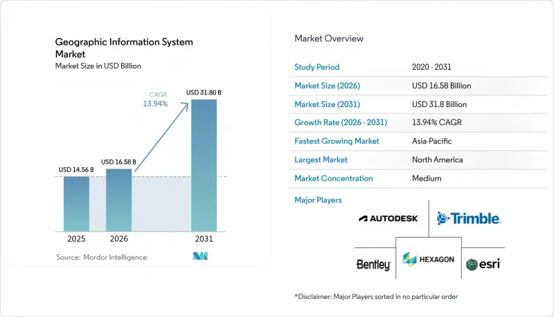
Mordor Intelligence에 의하면, 지리 정보 시스템(GIS) 시장 규모는 2025년에 145억 6,000만 달러로 평가되었고 2026년 165억 8,000만 달러에서 2031년까지 318억 달러에 이를 것으로 예측되며, 예측 기간(2026-2031년) CAGR은 13.94%를 나타낼 전망입니다.
본 보고서는 구성 요소(하드웨어, 소프트웨어, 서비스), 기능(매핑, 측량 등), 도입 형태(On-Premise, 클라우드), 최종 사용자 산업(농업, 유틸리티, 광업, 건설 등) 및 지역별로 분류되어 있습니다. 시장 예측은 금액(달러) 기준으로 제시되어 있습니다.
전 세계 지리 정보 시스템(GIS) 시장 동향 및 인사이트
스마트 시티의 광범위한 확산에는 실시간 지리공간 인프라가 필수적입니다.
각 지자체 기관은 도시 서비스를 통합적으로 운영하기 위해 지리 정보 시스템(GIS) 시장 플랫폼을 5G, IoT, 엣지 컴퓨팅과 통합하고 있습니다. 싱가포르의 ‘Open Digital Platform’은 지리 공간 데이터 스트리밍을 통해 지역 냉방, 폐기물, 에너지를 동기화하여 사고 대응 및 인프라 가동률을 향상시키고 있습니다. 로스앤젤레스에서는 실시간 대시보드를 사용하여 긴급 대응팀의 경로를 결정하고 있으며, 피크 시간대에는 상황 파악을 위한 지도 조회 횟수가 350만 건에 달할 전망입니다. 지자체들이 디지털 트윈에 대한 예산을 편성함에 따라, 확장 가능한 3D 시각화, 센서 API, 사이버 보안 강화를 제공하는 벤더들이 공공 부문 IT 지출에서 점점 더 큰 비중을 차지하고 있습니다.
클라우드 네이티브 GIS가 TCO를 절감하고 엔터프라이즈 통합을 가속화
Bell Canada는 클라우드 네이티브 지리 공간 데이터 플랫폼으로의 전환을 통해 인프라 지출을 40-60% 절감했습니다. 이는 컨테이너화된 마이크로서비스와 관리형 업그레이드가 도입 주기를 얼마나 단축하는지 보여줍니다. Kubernetes 기반의 ArcGIS Enterprise 및 유사한 솔루션은 GIS 운영을 DevOps 파이프라인과 연동하여, 조달 지연 없이 재해 발생 시 동적인 확장성을 가능하게 합니다. 클라우드 데이터 웨어하우스의 푸시다운형 분석을 통해 ETL 병목 현상이 해소되면서, 지리 정보 시스템(GIS) 시장의 타겟층이 기존의 지도 제작 팀을 넘어 확대되고 있습니다.
OT 및 SCADA 시스템과의 레거시 IT 통합의 복잡성
최신 GIS와 수십년전의 SCADA를 통합하는 유틸리티자는 데이터 모델의 불일치, 프로토콜의 격차, 새로운 사이버 위협의 발생원에 직면하고 있습니다. Liberty Utilities는 반복적인 테스트와 미들웨어 개발로 인해 마이그레이션 일정을 18개월이나 연장했습니다. 이러한 일정 지연으로 인해 지출이 전문 서비스로 이동하면서, 지리 정보 시스템(GIS) 시장의 소프트웨어 마이그레이션이 둔화되고 있습니다.
부문 분석
지리 정보 시스템(GIS) 시장의 서비스 매출은 2026년에 급증했으며, 기업들이 클라우드 전환, AI 모델 튜닝, 라이프사이클 지원을 외부에 위탁함에 따라 연평균 성장률(CAGR) 15.45%로 성장할 전망입니다. 현재 매니지드 서비스 패키지에는 데이터 품질 감사, 보안 패치 적용, 연중무휴 24시간 모니터링이 포함되어 있어, 지출이 자본 지출에서 운영 예산으로 전환되고 있습니다. 소프트웨어는 여전히 2025년 매출의 53.60%를 차지하고 있으며, ArcGIS, Hexagon Networks, Trimble Cityworks의 각 포트폴리오가 핵심을 이루고 있습니다. 지속적인 업데이트 주기를 통해 Esri는 연간 매출의 약 28%를 연구 개발(R&D)에 재투자하여 기능 추가 속도를 높게 유지하고 있는 한편, 오픈 API 프레임워크를 통해 타사 확장 기능을 적극적으로 수용하고 있습니다. GNSS 수신기, LiDAR 스캐너, 내충격성 태블릿의 경우 하드웨어가 여전히 필수적이지만, 더 많은 기능이 소프트웨어 계층으로 이동함에 따라 이익률은 압박을 받고 있습니다. 그 결과, 센서 수는 증가하고 있음에도 불구하고 순수한 하드웨어 출하와 연계된 지리 정보 시스템(GIS) 시장의 성장세는 둔화되고 있습니다.
업계의 구매 담당자들은 성과 중심의 서비스 수준 계약(SLA)을 제공할 수 있는 공급업체를 선호합니다. 예를 들어, Hexagon이 2025년에 비핵심 자산을 매각하기로 결정함으로써 자본이 확보되었고, 이를 구독형 지원 서비스 확충에 투입했습니다. 교육 아카데미, DevOps 툴체인, 공인 파트너 네트워크는 이제 중요한 선정 기준이 되었으며, 이는 지리 정보 시스템(GIS) 시장 전체에서 라이선스 수에서 고객 성공 지표로의 전환이 진행되고 있음을 보여줍니다.
2025년, 매핑 분야는 34.10%의 점유율을 차지하며 모든 다운스트림 워크플로우에 공간적 맥락을 제공했습니다. 그러나 엣지 추론, 파운데이션 모델, 데이터 레이크하우스 아키텍처에 힘입어 애널리틱스 하위 부문이 연평균 성장률(CAGR) 15.70%로 가장 빠르게 성장하고 있습니다. 기업들은 예측형 지오펜싱을 ERP에 통합하고 있으며, 행정 기관들은 다중 스펙트럼 스택을 사용하여 도시 열섬 현상을 모델링하고 있습니다. 측량 분야는 안정적인 추이를 보이고 있으며, 드론을 활용한 사진측량 기술의 도입으로 기존에 1주일이 걸리던 지형 데이터 수집이 당일 내에 완료되는 성과물로 단축되었습니다.
텔레매틱스 분야는 전기차(EV)의 경로 최적화 및 콜드체인 모니터링을 통해 성장하고 있으며, EV 특유의 주행 거리 계산 기능이 통합되어 있습니다. 위치 기반 서비스는 매장 내 프로모션을 촉발하는 초개인화된 소매 앱을 통해 활성화되고 있지만, 스마트폰의 네이티브 OS API와의 경쟁으로 인해 공급업체의 이익률은 억제되고 있습니다. 전반적으로 지리 정보 시스템(GIS) 시장은 종합적인 데이터 패브릭 원칙에 기반하여 기능적 로드맵을 조정하고, 데이터 수집, 카탈로그화 및 AI 파이프라인을 단일 거버넌스 체계 아래 통합하고 있습니다.
지역 분석
북미는 성숙한 클라우드 인프라, 견실한 연구 개발(R&D) 자금, 그리고 상호 운용성과 메타데이터를 표준화하는 ‘미국 지리 공간 데이터법’과 같은 정부 기관의 의무화 조치 덕분에 2025년 지출의 37.80%를 차지했습니다. 연방 정부 프로그램은 산불 모델링, 광대역 격차 매핑, 중요 인프라의 복원력 확보를 위해 다년간의 예산을 확보하고 있습니다. Trimble과 같은 기업들은 혁신에 연간 6억 6,000만 달러 이상을 투자하고 있으며, 이 지역의 기술적 우위를 강화하는 특허를 창출하고 있습니다. 그러나 클라우드 스토리지 요금 급등은 페타바이트급 이미지 분석에 있어 비용상의 과제가 되고 있어, 지역에 기반을 둔 주권 클라우드 도입을 위한 협상이 진행 중입니다.
아시아태평양은 메가시티의 현대화와 인프라 부양책에 힘입어 지역별 최고 수준인 연평균 성장률(CAGR) 15.95%를 달성할 전망입니다. 싱가포르는 공간 제약을 완화하기 위해 3D 지하 매핑을 확대하고 있는 반면, 인도의 ‘디지털 트윈 미션’은 물류 회랑과 통합된 구획 수준의 지적 정보를 연계하고 있습니다. 사우디아라비아가 네이버와 체결한 10억 달러 규모의 디지털 트윈 공동 사업은 스마트 시티 리더십을 목표로 하는 걸프 국가들의 야망을 여실히 보여주고 있습니다. 지역적 과제로는 데이터 거주 규정의 파편화나 수출 규제의 불균일성이 꼽히지만, 국내 위성 발사와 주권형 클라우드 존 구축을 통해 의존도를 낮추는 추세가 이어지고 있습니다.
유럽의 성장은 고부가가치 데이터 세트의 민주화를 추진하는 INSPIRE 지침에 힘입어 견조한 추세를 보이고 있습니다. 오픈 액세스를 통해 기후 위험 평가 및 재생 에너지 입지 분석을 전문으로 하는 스타트업 기업들이 잇달아 탄생하고 있습니다. GDPR(EU 개인정보보호규정)은 아키텍처 설계에 영향을 미치며, 개인정보 보호 강화형 컴퓨팅 및 지역 내 처리를 촉진하고 있습니다. 남미, 중동 및 아프리카의 총 시장 규모는 비교적 작지만, 광물 탐사, 정밀 농업, 인프라 보안 분야에서 도입이 가속화되고 있습니다. 이러한 시장에서는 기존 시스템을 뛰어넘어 도입 초기부터 클라우드 네이티브 GIS를 채택하는 경우가 많으며, 이를 통해 그린필드 수요를 바탕으로 지리 정보 시스템(GIS) 시장 규모를 확대되고 있습니다.
기타 혜택:
- 엑셀 형식 시장 예측(ME) 시트
- 3개월간의 애널리스트 지원
자주 묻는 질문
목차
제1장 서론
제2장 조사 방법
제3장 주요 요약
제4장 시장 구도
제5장 시장 규모와 성장 예측
제6장 경쟁 구도
제7장 시장 기회와 향후 전망
JHS 26.09.07According to Mordor Intelligence, the geographic information system market size was valued at USD 14.56 billion in 2025 and estimated to grow from USD 16.58 billion in 2026 to reach USD 31.8 billion by 2031, at a CAGR of 13.94% during the forecast period (2026-2031).
This report is Segmented by Component (Hardware, Software, and Services), Function (Mapping, Surveying, and More), Deployment Mode (On-Premise and Cloud), End-User Industry (Agriculture, Utilities, Mining, Construction, and More), and Geography. The Market Forecasts are Provided in Terms of Value (USD).
Global Geographic Information System Market Trends and Insights
Widespread Smart-City Roll-Outs Require Real-Time Geospatial Infrastructure
City agencies are integrating the Geographic information system market platforms with 5G, IoT, and edge compute to orchestrate urban services. Singapore's Open Digital Platform synchronizes district cooling, waste, and energy through streaming geospatial feeds, improving incident response and infrastructure uptime. Los Angeles uses real-time dashboards to route emergency crews, drawing 3.5 million situational-awareness map views during peak events. As municipalities budget for digital twins, vendors that deliver scalable 3D visualization, sensor APIs, and cybersecurity hardening capture a growing portion of public-sector IT spend.
Cloud-Native GIS Lowers TCO and Speeds Enterprise Integration
Bell Canada saved 40-60% in infrastructure outlay by shifting to a cloud-native geospatial data platform, illustrating how containerized micro-services and managed upgrades shorten deployment cycles. ArcGIS Enterprise on Kubernetes and similar offerings align GIS operations with DevOps pipelines, allowing dynamic scaling during disaster events without procurement delays. Push-down analytics in cloud data warehouses eliminate ETL bottlenecks, widening the Geographic information system market addressable base beyond traditional mapping teams.
Legacy IT Integration Complexity with OT and SCADA Systems
Utilities merging modern GIS with decades-old SCADA confront data-model mismatches, protocol gaps, and new cyber-threat surfaces. Liberty Utilities extended its migration timeline by 18 months due to iterative testing and middleware development. These overruns shift spending toward professional services, slowing software conversions in the Geographic information system market.
Other drivers and restraints analyzed in the detailed report include:
- Mobile-First Field-Data-Collection Platforms Expand Addressable User Base
- AI-Powered Auto-Classification of Satellite Imagery Accelerates Analytics
- Persistent Data-Quality / Lineage Gaps in Crowdsourced Layers
For complete list of drivers and restraints, kindly check the Table Of Contents.
Segment Analysis
Services revenue in the Geographic information system market rose sharply in 2026, advancing at a 15.45% CAGR as enterprises outsourced cloud migration, AI model tuning, and lifecycle support. Managed-service bundles now cover data-quality audits, security patching, and 24/7 monitoring, shifting spending from capital to operating budgets. Software still accounts for 53.60% of 2025 sales, anchored by the ArcGIS, Hexagon NetWorks, and Trimble Cityworks portfolios. Their continuous update cadence, Esri reinvests roughly 28% of annual turnover into R&D, keeping feature velocity high, while open-API frameworks welcome third-party extensions. Hardware remains essential for GNSS receivers, lidar scanners, and rugged tablets, yet margins compress as more functions migrate into the software layer. The geographic information system market size tied to pure hardware shipments therefore grows more slowly, even as sensor count climbs.
Industry buyers favor vendors that can deliver outcome-oriented service-level agreements; for example, Hexagon's 2025 decision to divest non-core assets freed capital to bolster subscription support offerings. Training academies, DevOps toolchains, and certified partner networks now form critical selection criteria, signaling a pivot from license counts to customer success metrics across the Geographic information system market.
Mapping held a 34.10% share in 2025, furnishing the spatial context for every downstream workflow. Yet the analytics sub-segment is expanding fastest at 15.70% CAGR, powered by edge inference, foundation models, and data-lakehouse architectures. Enterprises embed predictive geofencing into ERPs, while authorities model urban heat islands through multi-spectral stacks. Surveying remains steady, reinvented through drone photogrammetry that compresses week-long terrain captures into same-day deliverables.
Telematics gains from electric-vehicle routing and cold-chain monitoring, integrating EV-specific range calculations. Location-based services flourish via hyper-personalized retail apps that trigger in-store promotions, though competition from native smartphone OS APIs keeps vendor margins in check. Overall, the Geographic information system market aligns functional roadmaps around holistic data-fabric principles, merging ingestion, cataloging, and AI pipelines under a single governance umbrella.
Complete Report Scope:
- By Component
- Hardware
- Software
- Services
- By Function
- Mapping
- Surveying
- Telematics and Navigation
- Location-based Services
- Geospatial Data Management and Analysis
- By Deployment Mode
- On-premise
- Cloud
- By End-user Industry
- Agriculture
- Utilities
- Mining
- Construction
- Transportation and Logistics
- Oil and Gas
- Government and Defence
- Telecommunications
- Other End-user Industries
- By Geography
- North America
- United States
- Canada
- Mexico
- South America
- Brazil
- Argentina
- Chile
- Rest of South America
- Europe
- Germany
- United Kingdom
- France
- Italy
- Spain
- Rest of Europe
- Asia-Pacific
- China
- India
- Japan
- South Korea
- Malaysia
- Singapore
- Australia
- Rest of Asia-Pacific
- Middle East and Africa
- Middle East
- United Arab Emirates
- Saudi Arabia
- Turkey
- Rest of Middle East
- Africa
- South Africa
- Nigeria
- Rest of Africa
- Middle East
- North America
Geography Analysis
North America preserved 37.80% of 2025 spending, thanks to mature cloud infrastructure, robust R&D funding, and agency mandates like the U.S. Geospatial Data Act that standardize interoperability and metadata. Federal programs secure multi-year budgets for wildfire modeling, broadband equity mapping, and critical-infrastructure resilience. Enterprises such as Trimble invest more than USD 660 million annually in innovation, generating patents that reinforce the region's technological edge. Yet rising cloud-de-storage fees pose cost challenges for petabyte-class imagery analytics, motivating negotiations for localized sovereign clouds.
Asia-Pacific is on track for the highest 15.95% regional CAGR, fuelled by megacity modernization and infrastructure stimulus. Singapore scales 3D underground mapping to mitigate space constraints, while India's Digital Twin Mission links logistics corridors with unified parcel-level cadasters. Saudi Arabia's USD 1 billion digital-twin collaboration with Naver underscores Gulf ambitions for smart-city leadership. Regional hurdles include fragmented data-residency rules and varying export controls, yet domestic satellite launches and sovereign cloud zones are mitigating dependencies.
Europe's growth remains steady, anchored by the INSPIRE directive that democratizes high-value datasets. Open access spawns start-ups specializing in climate-risk scoring and renewable-siting analytics. GDPR influences architecture design, spurring privacy-enhancing computation and in-region processing. South America, the Middle East, and Africa together represent a smaller base but display accelerated adoption in mineral exploration, precision agriculture, and infrastructure security. These markets often leapfrog legacy systems, adopting cloud-native GIS from inception, thereby enlarging the Geographic information system market size through greenfield demand.
- Environmental Systems Research Institute, Inc. (Esri)
- Hexagon AB
- Trimble Inc.
- Autodesk, Inc.
- Bentley Systems, Incorporated
- Topcon Positioning Systems, Inc.
- Pitney Bowes, Inc. (Precisely)
- Caliper Corporation
- Mapbox, Inc.
- Maxar Technologies Inc.
- Fugro N.V.
- SuperMap Software Co., Ltd.
- CARTO (CartoDB Inc.)
- Blue Marble Geographics, LLC
- GIS Cloud Ltd.
- TomTom N.V.
- Seequent Limited
- Spatialworks, Inc.
- Geosoft Inc.
- Woolpert, Inc.
- NV5 Geospatial Solutions, Inc.
- BlackSky Technology Inc.
Additional Benefits:
- The market estimate (ME) sheet in Excel format
- 3 months of analyst support
TABLE OF CONTENTS
1 INTRODUCTION
- 1.1 Study Assumptions and Market Definition
- 1.2 Scope of the Study
2 RESEARCH METHODOLOGY
3 EXECUTIVE SUMMARY
4 MARKET LANDSCAPE
- 4.1 Market Overview
- 4.2 Market Drivers
- 4.2.1 Widespread smart-city roll-outs require real-time geospatial infrastructure
- 4.2.2 Cloud-native GIS lowers TCO and speeds enterprise integration
- 4.2.3 Mobile-first field-data-collection platforms expand addressable user base
- 4.2.4 AI-powered auto-classification of satellite imagery accelerates analytics
- 4.2.5 Sub-30 cm commercial microsatellite constellations unlock new precision use-cases
- 4.2.6 National open-data mandates (EU INSPIRE 2.0, US GDA, etc.) drive adoption
- 4.3 Market Restraints
- 4.3.1 Legacy IT integration complexity with OT and SCADA systems
- 4.3.2 Persistent data-quality/lineage gaps in crowdsourced layers
- 4.3.3 Rising cloud-egress fees for petabyte-scale imagery archives
- 4.3.4 Export-control tightening on high-resolution geospatial data
- 4.4 Value Chain Analysis
- 4.5 Regulatory Landscape
- 4.6 Technological Outlook
- 4.7 Industry Attractiveness - Porter's Five Forces Analysis
- 4.7.1 Bargaining Power of Suppliers
- 4.7.2 Bargaining Power of Buyers
- 4.7.3 Threat of New Entrants
- 4.7.4 Threat of Substitutes
- 4.7.5 Intensity of Competitive Rivalry
- 4.8 Impact of Macroeconomic Factors on the Market
5 MARKET SIZE AND GROWTH FORECASTS (VALUES)
- 5.1 By Component
- 5.1.1 Hardware
- 5.1.2 Software
- 5.1.3 Services
- 5.2 By Function
- 5.2.1 Mapping
- 5.2.2 Surveying
- 5.2.3 Telematics and Navigation
- 5.2.4 Location-based Services
- 5.2.5 Geospatial Data Management and Analysis
- 5.3 By Deployment Mode
- 5.3.1 On-premise
- 5.3.2 Cloud
- 5.4 By End-user Industry
- 5.4.1 Agriculture
- 5.4.2 Utilities
- 5.4.3 Mining
- 5.4.4 Construction
- 5.4.5 Transportation and Logistics
- 5.4.6 Oil and Gas
- 5.4.7 Government and Defence
- 5.4.8 Telecommunications
- 5.4.9 Other End-user Industries
- 5.5 By Geography
- 5.5.1 North America
- 5.5.1.1 United States
- 5.5.1.2 Canada
- 5.5.1.3 Mexico
- 5.5.2 South America
- 5.5.2.1 Brazil
- 5.5.2.2 Argentina
- 5.5.2.3 Chile
- 5.5.2.4 Rest of South America
- 5.5.3 Europe
- 5.5.3.1 Germany
- 5.5.3.2 United Kingdom
- 5.5.3.3 France
- 5.5.3.4 Italy
- 5.5.3.5 Spain
- 5.5.3.6 Rest of Europe
- 5.5.4 Asia-Pacific
- 5.5.4.1 China
- 5.5.4.2 India
- 5.5.4.3 Japan
- 5.5.4.4 South Korea
- 5.5.4.5 Malaysia
- 5.5.4.6 Singapore
- 5.5.4.7 Australia
- 5.5.4.8 Rest of Asia-Pacific
- 5.5.5 Middle East and Africa
- 5.5.5.1 Middle East
- 5.5.5.1.1 United Arab Emirates
- 5.5.5.1.2 Saudi Arabia
- 5.5.5.1.3 Turkey
- 5.5.5.1.4 Rest of Middle East
- 5.5.5.2 Africa
- 5.5.5.2.1 South Africa
- 5.5.5.2.2 Nigeria
- 5.5.5.2.3 Rest of Africa
- 5.5.5.1 Middle East
- 5.5.1 North America
6 COMPETITIVE LANDSCAPE
- 6.1 Market Concentration
- 6.2 Strategic Moves
- 6.3 Market Share Analysis
- 6.4 Company Profiles (includes Global level Overview, Market level overview, Core Segments, Financials as available, Strategic Information, Market Rank/Share for key companies, Products and Services, and Recent Developments)
- 6.4.1 Environmental Systems Research Institute, Inc. (Esri)
- 6.4.2 Hexagon AB
- 6.4.3 Trimble Inc.
- 6.4.4 Autodesk, Inc.
- 6.4.5 Bentley Systems, Incorporated
- 6.4.6 Topcon Positioning Systems, Inc.
- 6.4.7 Pitney Bowes, Inc. (Precisely)
- 6.4.8 Caliper Corporation
- 6.4.9 Mapbox, Inc.
- 6.4.10 Maxar Technologies Inc.
- 6.4.11 Fugro N.V.
- 6.4.12 SuperMap Software Co., Ltd.
- 6.4.13 CARTO (CartoDB Inc.)
- 6.4.14 Blue Marble Geographics, LLC
- 6.4.15 GIS Cloud Ltd.
- 6.4.16 TomTom N.V.
- 6.4.17 Seequent Limited
- 6.4.18 Spatialworks, Inc.
- 6.4.19 Geosoft Inc.
- 6.4.20 Woolpert, Inc.
- 6.4.21 NV5 Geospatial Solutions, Inc.
- 6.4.22 BlackSky Technology Inc.
7 MARKET OPPORTUNITIES AND FUTURE OUTLOOK
- 7.1 White-space and Unmet-Need Assessment