
|
시장보고서
상품코드
1640360
육상 분야 관성 시스템 : 시장 점유율 분석, 산업 동향과 통계, 성장 예측(2025-2030년)Inertial Systems in Land-based Applications - Market Share Analysis, Industry Trends & Statistics, Growth Forecasts (2025 - 2030) |
||||||
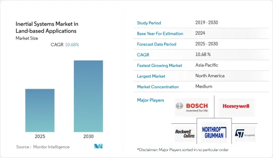
육상 분야 관성 시스템 시장은 예측 기간 동안 10.68%의 연평균 복합 성장률(CAGR)을 나타낼 것으로 예측됩니다.
미세 전자 기계 시스템(MEMS) 기술의 출현으로 센서 및 반도체 분야의 기계적 및 전기 기계적 요소가 미세 가공 기술과 마이크로 머시닝 기술에 의해 소형화되었습니다. 따라서 MEMS는 미래의 네비게이션 시스템의 일부가 되어 관성 시스템 시장 성장을 가속할 것으로 기대되고 있습니다.
또한 하이엔드 관성 시스템은 고성능 센서(자이로스코프, 지자기 센서, 가속도 센서)를 갖춘 IMU로 구성되어 상대 운동을 통해 주변 환경에 대한 정밀 정보를 제공합니다. 따라서 네비게이션 시스템에서 보다 높은 정밀도의 필요성이 높아지고 있으며 고급 관성 시스템에 대한 수요가 높아지고 있습니다.
또한, 이러한 관성 시스템은 심해 시추 장비에서 복잡한 작업을 수행하는 데 종종 사용됩니다. 소나다인 인터내셔널은 장기선 및 초단기선(LUSBL) 측위 기술의 상보적 특성과 Lodestar AHRS/INS 플랫폼으로부터의 고정밀 관성 계측을 조합한 새로운 DP-INS(관성 항법 시스템)를 개발했습니다. 또한 자이로 센서는 고도 각도와 각속도를 감지하는 데 사용되는 관성 센서의 일종으로 소형, 저소비 전력, 경량, 저비용, 그리고 일괄 제작이 가능한 특징이 있어 종래의 자이로스코프보다 더 많이 도입되고 있습니다.
또한 COVID-19의 유행으로 중국은 반도체 산업을 포함한 모든 주요 생산 활동을 중단하고 있습니다. 이는 2020년 세계의 산업용 관성 시스템 시장공급망에 큰 영향을 미칠 것으로 예상되며 시장은 그 후 다시 회복될 것으로 예상됩니다. 중국의 혼란은 세계 기업 및 전자 제품의 밸류체인에 큰 영향을 미치고 센서 시장에 직접적인 영향을 줄 수 있습니다.
육상 분야 관성 시스템 시장 동향
정확성 요구 증가가 시장을 견인
높은 정확도와 신뢰성은 항법 시스템의 가장 큰 특징입니다. 관성 항법 시스템은 이동 물체의 회전과 가속도를 결정할 때 외부 도움에 의존하지 않는다는 점에서 다른 형태의 항법 시스템보다 명확한 이점이 있습니다. 이러한 시스템은 자이로스코프, 가속도계, 자력계를 조합하여 차량과 이동체의 벡터 변수를 결정합니다.
네비게이션 시스템은 본래 복잡한 환경에서 차량의 통합 네비게이션, 제어 및 안내에 적합합니다. GPS 및 기타 네비게이션 시스템과 달리 관성 시스템은 복잡한 조건에서도 성능을 유지할 수 있습니다. 관성 측정 유닛(IMU)은 여러 지표를 계산하는 네비게이션 시스템에 적합합니다. 이러한 시스템은 방사선이나 방해 전파의 영향을 받지 않습니다. 관성 네비게이션 시스템은 짐벌 시스템보다 스트랩 다운 시스템을 더 많이 사용합니다. 게다가 MEMS 기술이 내장되어 있어 비용 효과도 높습니다.
AI나 머신러닝 등의 선진 기술이 널리 채용됨에 따라 센서 기술에 의해 원격 조작할 수 있는 고도의 로봇카가 일반화되고 있습니다. 무인잠수정, 무인항공기 및 무인자동차는 모두 이 새로운 기술로 업데이트되었습니다. 그 결과 오늘날의 전투 시나리오에서는 고도 및 전술 등급 장비의 방향 등 정확한 위치 매개변수가 중요합니다.
관성 항법 시스템은 현재 민간 항공기, UAV, 군사, 방위 유닛 분야에서 상업화되어 있습니다. 관성 항법 시스템은 항법 제어 시스템의 필수적인 부분을 형성하고 시스템의 처리 능력의 점진적인 발전으로 다른 항법 시스템과 상호 작용할 수 있습니다. 자력계와 같은 여러 관성 시스템은 다른 형태의 관성 시스템과 결합하여 방위와 자기장을 측정하는 데 널리 사용됩니다.
북미가 가장 큰 시장 점유율을 차지
이 지역에는 MEMS를 제공하는 유력 벤더가 존재하기 때문에 기술 혁신의 원천으로 대두할 가능성이 높고, 따라서 큰 시장 점유율을 차지할 것으로 추정됩니다. 북미는 해양 석유 및 가스 통신의 세계 최대 시장 중 하나입니다. 미국에서 새롭게 발견된 셰일 자원과 캐나다에서의 석유 및 가스 프로젝트 증가가 이 지역의 통신기기 수요를 견인할 것으로 예상됩니다.
미국 내무부(DoI)는 외변대륙붕(OCS) 에이커의 약 90%에서 해양 시굴을 허용할 계획입니다. 이 지역의 석유 및 가스 부문은 2019-2024년 국가 외변대륙붕 석유 및 가스 리스 계획(국가 OCS 계획) 하에서 새로운 기회를 창출할 것으로 기대되고 있습니다.
무인항공기의 대수 증가와 국방비 증가가 미국에서 이러한 시스템의 채용 증가로 이어지고 있습니다. 게다가 미국 국방고등연구계획국(DARPA) 프로그램 하에서 수중 센서의 도달범위와 유효성을 높이기 위한 선진적인 툴을 미국 해군에 제공하기 위해, 미국의 방위부문은 미국의 잠수함이 적 잠수함 감지와 교전을 지원하는 소형 무인잠수정(UUV) 개발 및 투자에 따라서 정부의 이니셔티브와 연구개발에 대한 지출은 이 지역 시장 성장을 더욱 자극할 것으로 예상됩니다.
육상 분야 관성 시스템 산업 개요
육상 분야에서 관성 시스템 시장 경쟁 구도는 다양한 관성 시스템 솔루션 공급자가 존재하기 때문에 적당히 단편화되었습니다. 그러나 공급업체는 지속적으로 제품 개발에 주력하여 지명도와 세계 시장 존재감을 높이고 있습니다. 또한 각 회사는 전략적 제휴와 인수를 실시하여 시장 견인력과 점유율 확대를 도모하고 있습니다.
2021년 10월, 미해군은 노스롭 그라만사로부터 500대째의 WSN-7 링 레이저 자이로스코프 관성 항법 시스템(INS)을 인수했습니다. 노스롭 그라만은 미국 해군 함대 전체에 설치되어 미국과 NATO의 수상 및 잠수함 해군 자산을 전 세계적으로 지원하고 있습니다.
2021년 4월 이너셜 랩은 차세대 GPS 지원 시스템인 INS-DH-OEM, IMU-NAV-100 및 INS-U의 출시를 발표했습니다. INS는 UAV, 헬리콥터 및 상공에서 LiDAR 조사에 사용되며 MEMS 가속도계와 MEMS 자이로스코프도 포함합니다.
기타 혜택
- 엑셀 형식 시장 예측(ME) 시트
- 3개월간의 애널리스트 서포트
목차
제1장 서론
- 조사의 전제조건과 시장 정의
- 조사 범위
제2장 조사 방법
제3장 주요 요약
제4장 시장 인사이트
- 시장 개요
- 밸류체인/서플라이체인 분석
- 업계의 매력도 - Porter's Five Forces 분석
- 신규 참가업체의 위협
- 구매자의 협상력
- 공급기업의 협상력
- 대체품의 위협
- 경쟁 기업간 경쟁 관계의 강도
- COVID-19의 업계에 대한 영향 평가
제5장 시장 역학
- 촉진요인
- MEMS 기술의 출현
- 모션 센싱에 근거한 용도 증가
- 억제요인
- 통합 드리프트 에러
제6장 시장 세분화
- 컴포넌트별
- 가속도계
- IMU
- 자이로스코프
- 자력계
- 자세 헤딩
- 레퍼런스 시스템
- 지역별
- 북미
- 유럽
- 아시아태평양
- 세계 기타 지역
제7장 경쟁 구도
- 기업 프로파일
- Honeywell International Inc.
- Northrop Grumman Corporation
- Rockwell Collins
- Bosch Sensortec GmbH
- ST Microelectronics
- Safran Group
- SBG Systems
- Raytheon Anschtz GmbH
- KVH Industries Inc.
- Silicon Sensing Systems Ltd
- Vector NAV
제8장 투자 분석
제9장 미래 전망
CSM 25.02.17The Inertial Systems Market in Land-based Applications Industry is expected to register a CAGR of 10.68% during the forecast period.

The emergence of Micro Electro Mechanical Systems (MEMS) technology resulted in the miniaturization of mechanical and electro-mechanical elements in the field of sensors and semiconductors through the use of micro-fabrication and micro-machining techniques. Hence, MEMS has become an indisputable part of future navigation systems and is expected to propel the inertial systems market's growth.
Additionally, high-end inertial systems are comprised of IMU with high-performance sensors (gyroscopes, magnetometers, accelerometers), which provide high accuracy information about the surrounding environment through relative movement. Hence, the need for higher accuracy in navigation systems is increasing, thus, increasing the demand for advanced inertial systems.
Moreover, these inertial systems are increasingly used in deep-water drilling units for advanced operations. Sonardyne International came up with a new DP-INS (inertial navigation system) that combined the complementary characteristics of its long and ultra-short baseline (LUSBL) positioning technology with high-integrity inertial measurements from its Lodestar AHRS/INS platform. Further, a gyroscope is a kind of inertial sensor used to detect the altitude angle and angular rate. Characteristics such as small size, low power consumption, lightweight, low cost, and the possibility of batch fabrication drive their adoption over conventional gyroscopes.
Further, due to the COVID-19 pandemic, China has stopped all major production activities, including its semiconductor industry. This is expected to significantly influence the global industrial inertial systems market supply chain in 2020, and the market is expected to pick up afterward. Disruption in China may significantly impact companies worldwide and up and down the electronics value chain, directly impacting the sensor market.
Land-based Applications Inertial Systems Market Trends
Increasing Demand for Accuracy to Drive the Market
A high level of accuracy and reliability is a navigational system's prime feature. Inertial navigational systems have a distinct advantage over other forms of navigation systems in terms of their lack of dependence on external aids to determine the rotation and acceleration of a moving object. These systems use a combination of gyroscopes, accelerometers, and magnetometers to determine the vector variables of a vehicle or a moving object.
Navigational systems are inherently suited for use in integrated navigation, control, and guidance of vehicles in challenging environs. Unlike GPS and other navigation systems, inertial systems can retain their performance even under challenging conditions. Inertial measurement units (IMU) are well suited for navigational systems to calculate several metrics. These systems remain unaffected by radiation and jamming problems. Strapdown inertial systems find more usage in inertial navigation systems than gimbaled systems, as they are strapped to the moving object and offer better reliability and performance. Moreover, they provide cost-effectiveness as they are incorporated with MEMS techniques.
As advanced technologies such as AI and Machine Learning become more widely adopted, advanced robotic cars that can be controlled remotely via sensor technology are becoming more common. Unmanned Underwater Vehicles, Unmanned Aerial Vehicles, and Unmanned Ground Vehicles are all being updated owing to this new technology. As a result, accurate position parameters, such as altitude and orientation of tactical grade equipment, are important in today's battle scenario.
Inertial navigation systems are now being made available for commercial use in private aircraft, UAVs, military, and defense units. They form an integral part of the navigational control systems and can interact with other navigational systems due to incremental advancements in the processing ability of the systems. Several forms of inertial systems like magnetometers are widely used for determining the orientation and presence of a magnetic field in conjunction with other forms of inertial systems.
North America to Hold the Largest Market Share
The presence of prominent vendors offering MEMS in the region is likely to emerge as a source for innovation, and it is estimated to hold a significant market share. North America is one of the largest markets for offshore oil and gas communication globally. New-found shale resources in the US and an increasing number of oil and gas projects in Canada are expected to drive the demand for communication equipment in the region.
The US Department of the Interior (DoI) plans to allow offshore exploratory drilling in about 90% of the Outer Continental Shelf (OCS) acreage. The region's oil and gas sector is expected to create new opportunities under the National Outer Continental Shelf Oil and Gas Leasing Program (National OCS Program) for 2019-2024.
Moreover, the rising number of unmanned aerial vehicles and rising defense spending are the key reasons for the high adoption of these systems in the US. Besides, under the US Defense Advanced Research Projects Agency (DARPA) program, to provide the US Navy with advanced tools to expand the reach and effectiveness of its underwater sensors, the US defense sector has invested in the development of small unmanned underwater vehicles (UUV) to help US submarines detect and engage adversary submarines. Hence, government initiatives and spending on R&D are expected to further stimulate the growth of the market in the region.
Land-based Applications Inertial Systems Industry Overview
The competitive landscape of the inertial systems market in land-based applications is fragmented moderately due to the presence of various inertial systems solution providers. However, vendors are consistently focusing on product development to enhance their visibility and global presence. Companies are also undergoing strategic partnerships and acquisitions to gain traction and increase their market share.
In October 2021, the US Navy received the 500th WSN-7 ring laser gyroscope inertial navigation system (INS) from Northrop Grumman Corporation. Northrop Grumman continues to support the US and NATO surface and submarine naval assets worldwide, with installations across the US Navy Fleet.
In April 2021, Inertial Labs announced the release of INS-DH-OEM, IMU-NAV-100, and INS-U, the next generation of GPS-assisted systems. These INS are intended for use with UAVs, helicopters, and LiDAR surveys from the air. MEMS accelerometers and MEMS gyroscopes are among them.
Additional Benefits:
- The market estimate (ME) sheet in Excel format
- 3 months of analyst support
TABLE OF CONTENTS
1 INTRODUCTION
- 1.1 Study Assumptions and Market Definition
- 1.2 Scope of the Study
2 RESEARCH METHODOLOGY
3 EXECUTIVE SUMMARY
4 MARKET INSIGHTS
- 4.1 Market Overview
- 4.2 Value Chain/Supply Chain Analysis
- 4.3 Industry Attractiveness - Porter's Five Forces Analysis
- 4.3.1 Threat of New Entrants
- 4.3.2 Bargaining Power of Buyers
- 4.3.3 Bargaining Power of Suppliers
- 4.3.4 Threat of Substitute Products
- 4.3.5 Intensity of Competitive Rivalry
- 4.4 Assessment of COVID-19 Impact on the Industry
5 MARKET DYNAMICS
- 5.1 Market Drivers
- 5.1.1 Emergence of MEMS Technology
- 5.1.2 Increasing Applications Based on Motion Sensing
- 5.2 Market Restraints
- 5.2.1 Integration Drift Error
6 MARKET SEGMENTATION
- 6.1 By Component
- 6.1.1 Accelerometers
- 6.1.2 IMUs
- 6.1.3 Gyroscopes
- 6.1.4 Magnetometers
- 6.1.5 Attitude Heading
- 6.1.6 Reference Systems
- 6.2 By Geography
- 6.2.1 North America
- 6.2.2 Europe
- 6.2.3 Asia-Pacific
- 6.2.4 Rest of the World
7 COMPETITIVE LANDSCAPE
- 7.1 Company Profiles
- 7.1.1 Honeywell International Inc.
- 7.1.2 Northrop Grumman Corporation
- 7.1.3 Rockwell Collins
- 7.1.4 Bosch Sensortec GmbH
- 7.1.5 ST Microelectronics
- 7.1.6 Safran Group
- 7.1.7 SBG Systems
- 7.1.8 Raytheon Anschtz GmbH
- 7.1.9 KVH Industries Inc.
- 7.1.10 Silicon Sensing Systems Ltd
- 7.1.11 Vector NAV
