
|
시장보고서
상품코드
2061303
상용 지구 관측 위성 시장 기회, 성장요인, 업계 동향 분석 및 예측(2026-2035년)Commercial Earth Observation Satellite Market Opportunity, Growth Drivers, Industry Trend Analysis, and Forecast 2026 - 2035 |
||||||
세계의 상용 지구 관측 위성 시장은 2025년에 47억 달러로 평가되고 CAGR 9.2%로 성장하며, 2035년까지 114억 달러에 달할 것으로 추정되고 있습니다.
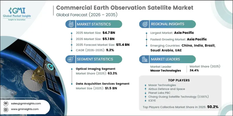
이 시장은 다양한 분야에서 첨단 정밀한 지리공간 정보에 대한 수요가 증가함에 따라 견고한 성장세를 보이고 있습니다. 환경 모니터링, 재난 대응, 농업 최적화, 천연자원 평가에 대한 관심이 높아지면서 시장 확대에 크게 기여하고 있습니다. 위성 이미지 기술의 발전과 발사 비용의 감소가 맞물리면서, 상업용 사용자들이 우주에서 얻은 데이터에 더 쉽게 접근할 수 있게 되었습니다. 동시에, 분석 플랫폼의 발전으로 인해 위성 데이터에서 얻을 수 있는 인사이트의 유용성과 상업적 가치가 높아지고 있습니다. 공공 부문과 민간 부문 모두에서 의사결정시 실시간 공간 인텔리전스에 대한 의존도가 높아지고 있는 것이 도입을 더욱 가속화하고 있습니다. 인공지능(AI)과 클라우드 기반 처리 시스템의 통합 또한 데이터 해석 능력을 혁신하고 있으며, 이를 통해 더 신속하게 인사이트를 확보하고 더 효율적인 운영 계획을 수립할 수 있게 해줍니다. 전반적으로 기술 혁신과 응용 분야의 확대가 맞물려 장기적인 시장 성장을 더욱 공고히 하고 있습니다.
| 시장 범위 | |
|---|---|
| 시작연도 | 2025년 |
| 예측 기간 | 2026-2035년 |
| 개시 금액 | 47억 달러 |
| 예측 시장 규모 | 114억 달러 |
| CAGR | 9.2% |
광학 이미징 분야는 농업, 도시 개발, 환경 감시 및 기타 대규모 모니터링 용도로 광범위하게 활용됨에 따라 2025년에는 63.3%의 시장 점유율을 차지했습니다. 광학 영상 위성은 지표면의 상태를 정확하게 파악할 수 있는 고해상도 영상 데이터를 제공하므로 정부 및 민간 사용자 모두에게 매우 높은 가치를 지닙니다. 높은 신뢰성과 뛰어난 비용 대비 효과, 그리고 상세한 이미지를 제공할 수 있는 그 능력은 다양한 산업 분야에서 지속적인 수요를 지원하고 있습니다.
데이터 수집 서비스 부문은 고해상도 위성 이미지에 대한 지속적인 접근 수요가 증가함에 따라 2025년에는 15억 달러에 달했습니다. 이러한 서비스들은 국방, 농업, 환경 분석 등의 분야에서 활용되는 생물지리공간 데이터의 공급에 있으며, 매우 중요한 역할을 하고 있습니다. 하류 분석 및 정보에 기반한 의사결정 과정을 가능하게 한다는 점에서 그 중요성은 안정적인 수요를 확보하고, 지구 관측 밸류체인에서 중심적인 역할을 확고히 하고 있습니다.
2025년, 북미의 상업용 지구 관측 위성 시장은 39.8%의 점유율을 차지했습니다. 이 지역은 방위·정보 기관의 고해상도 지리공간 정보 및 첨단 감시 능력에 대한 수요 증가에 힘입어 강력한 성장을 달성하고 있습니다. 위성을 통해 얻은 정보가 국가 안보 체계, 인프라 개발, 국경 감시 활동에 더욱 광범위하게 통합되고 있다는 점이 정부 부문과 민간 부문 모두에서 위성 기술의 도입을 더욱 촉진하고 있습니다. 또한 주요 우주 기술 기업과 위성 사업자들의 투자 증가로 인해 해당 지역 전체에서 첨단 위성 군집 및 분석 플랫폼의 구축이 가속화되고 있습니다.
자주 묻는 질문
목차
제1장 조사 방법과 범위
제2장 개요
제3장 업계 인사이트
제4장 경쟁 구도
제5장 시장 추산·예측 : 기술 유형별, 2022-2035년
제6장 시장 추산·예측 : 서비스 유형별, 2022-2035년
제7장 시장 추산·예측 : 궤도 유형별, 2022-2035년
제8장 시장 추산·예측 : 최종사용자별, 2022-2035년
제9장 시장 추산·예측 : 지역별, 2022-2035년
제10장 기업 개요
KSAThe Global Commercial Earth Observation Satellite Market was valued at USD 4.7 billion in 2025 and is estimated to grow at a CAGR of 9.2% to reach USD 11.4 billion by 2035.

The market is witnessing strong growth driven by rising demand for high-precision geospatial intelligence across multiple sectors. Increasing emphasis on environmental monitoring, disaster response, agriculture optimization, and natural resource assessment is significantly supporting market expansion. Improvements in satellite imaging technologies, combined with lower launch costs, are making space-based data more accessible to commercial users. At the same time, advancements in analytics platforms are enhancing the usability and commercial value of satellite-derived insights. Growing reliance on real-time spatial intelligence for decision-making in both public and private sectors is further accelerating adoption. The integration of artificial intelligence and cloud-based processing systems is also transforming data interpretation capabilities, enabling faster insights and more efficient operational planning. Overall, the convergence of technological innovation and expanding application areas continues to strengthen long-term market growth.
| Market Scope | |
|---|---|
| Start Year | 2025 |
| Forecast Year | 2026-2035 |
| Start Value | $4.7 Billion |
| Forecast Value | $11.4 Billion |
| CAGR | 9.2% |
The optical imaging segment held a 63.3% share in 2025, owing to its extensive use in agriculture, urban development, environmental surveillance, and other large-scale monitoring applications. Optical imaging satellites deliver high-resolution visual data that enables precise interpretation of surface conditions, making them highly valuable for both government and commercial users. Their ability to provide reliable, cost-effective, and detailed imagery supports sustained demand across multiple industries.
The data acquisition services segment reached USD 1.5 billion in 2025, driven by the growing requirement for continuous access to high-resolution satellite imagery. These services play a fundamental role in supplying raw geospatial data used across defense, agriculture, and environmental analysis applications. Their importance in enabling downstream analytics and informed decision-making processes ensures consistent demand and reinforces their central role in the earth observation value chain.
North America Commercial Earth Observation Satellite Market accounted for a 39.8% share in 2025. The region is experiencing strong growth supported by increasing demand from defense and intelligence organizations for high-resolution geospatial intelligence and advanced surveillance capabilities. Expanding integration of satellite-based insights into national security frameworks, infrastructure development, and border monitoring operations is further driving adoption across both government and commercial sectors. In addition, rising investments by major space technology firms and satellite operators are accelerating the deployment of advanced satellite constellations and analytics platforms across the region.
Major companies operating in the Global Commercial Earth Observation Satellite Market include Planet Labs PBC, Maxar Technologies, Airbus Defence and Space, BlackSky Technology, ICEYE, Capella Space, Satellogic, Spire Global, GHGSat, HawkEye 360, Pixxel, Chang Guang Satellite Technology (CGSTL), Synspective, iQPS (Institute for Q-shu Pioneers of Space), OroraTech, Orbital Insight, and Descartes Labs. Companies operating in the commercial earth observation satellite market are focusing on expanding satellite constellations to improve revisit frequency and data coverage across global regions. They are heavily investing in artificial intelligence and machine learning-based analytics to enhance image processing accuracy and reduce time-to-insight for end users. Strategic partnerships with government agencies, defense organizations, and commercial enterprises are being strengthened to expand application reach and long-term contracts. Many players are also adopting cloud-native platforms to enable scalable data distribution and easier integration with enterprise workflows. Cost optimization through small satellite deployment and shared launch systems is another key strategy for improving commercial viability. Firms are additionally prioritizing the development of high-resolution imaging sensors and advanced radar technologies to improve data quality.
Table of Contents
Chapter 1 Methodology and Scope
- 1.1 Market scope and definition
- 1.2 Research design
- 1.2.1 Research approach
- 1.2.2 Data collection methods
- 1.3 Data mining sources
- 1.3.1 Global
- 1.3.2 Regional/Country
- 1.4 Base estimates and calculations
- 1.4.1 Base year calculation
- 1.4.2 Key trends for market estimation
- 1.5 Primary research and validation
- 1.5.1 Primary sources
- 1.6 Forecast model
- 1.7 Research assumptions and limitations
Chapter 2 Executive Summary
- 2.1 Industry 360° synopsis, 2022 - 2035
- 2.2 Key market trends
- 2.2.1 Technology type trends
- 2.2.2 Service type trends
- 2.2.3 Orbit type trends
- 2.2.4 End-User trends
- 2.2.5 Regional trends
- 2.3 TAM Analysis, 2026-2035
- 2.4 CXO perspectives: Strategic imperatives
Chapter 3 Industry Insights
- 3.1 Industry ecosystem analysis
- 3.1.1 Supplier Landscape
- 3.1.2 Profit Margin
- 3.1.3 Cost structure
- 3.1.4 Value addition at each stage
- 3.1.5 Factor affecting the value chain
- 3.1.6 Disruptions
- 3.2 Industry impact forces
- 3.2.1 Growth drivers
- 3.2.1.1 Rising demand for real-time geospatial intelligence
- 3.2.1.2 Increasing climate monitoring and disaster management requirements
- 3.2.1.3 Expansion of precision agriculture and natural resource monitoring
- 3.2.1.4 Declining satellite launch costs and growth of small satellite constellations
- 3.2.1.5 Integration of AI and cloud based geospatial analytics platforms
- 3.2.2 Industry pitfalls and challenges
- 3.2.2.1 High data processing and analysis complexity
- 3.2.2.2 Regulatory restrictions and data privacy concerns
- 3.2.3 Market opportunities
- 3.2.3.1 Expansion into insurance, financial services, and risk analytics
- 3.2.3.2 Development of digital twins and geospatial simulation platforms
- 3.2.1 Growth drivers
- 3.3 Growth potential analysis
- 3.4 Regulatory landscape
- 3.4.1 North America
- 3.4.2 Europe
- 3.4.3 Asia Pacific
- 3.4.4 Latin America
- 3.4.5 Middle East & Africa
- 3.5 Porter’s analysis
- 3.6 PESTEL analysis
- 3.7 Technology and Innovation landscape
- 3.7.1 Current technological trends
- 3.7.2 Emerging technologies
- 3.8 Price trends
- 3.8.1 By region
- 3.8.2 By product
- 3.9 Pricing Strategies
- 3.10 Emerging Business Models
- 3.11 Compliance Requirements
- 3.12 Patent and IP analysis
Chapter 4 Competitive Landscape, 2025
- 4.1 Introduction
- 4.2 Company market share analysis
- 4.2.1 By region
- 4.2.1.1 North America
- 4.2.1.2 Europe
- 4.2.1.3 Asia Pacific
- 4.2.1.4 Latin America
- 4.2.1.5 Middle East & Africa
- 4.2.2 Market concentration analysis
- 4.2.1 By region
- 4.3 Competitive benchmarking of key players
- 4.3.1 Financial performance comparison
- 4.3.1.1 Revenue
- 4.3.1.2 Profit margin
- 4.3.1.3 R&D
- 4.3.2 Product portfolio comparison
- 4.3.2.1 Product range breadth
- 4.3.2.2 Technology
- 4.3.2.3 Innovation
- 4.3.3 Geographic presence comparison
- 4.3.3.1 Global footprint analysis
- 4.3.3.2 Service network coverage
- 4.3.3.3 Market penetration by region
- 4.3.4 Competitive positioning matrix
- 4.3.4.1 Leaders
- 4.3.4.2 Challengers
- 4.3.4.3 Followers
- 4.3.4.4 Niche players
- 4.3.5 Strategic outlook matrix
- 4.3.1 Financial performance comparison
- 4.4 Key developments
- 4.4.1 Mergers and acquisitions
- 4.4.2 Partnerships and collaborations
- 4.4.3 Technological advancements
- 4.4.4 Expansion and investment strategies
- 4.4.5 Digital transformation initiatives
- 4.5 Emerging/ startup competitors landscape
Chapter 5 Market Estimates and Forecast, By Technology Type, 2022 - 2035 (USD Million)
- 5.1 Key trends
- 5.2 Optical imaging
- 5.2.1 Panchromatic
- 5.2.2 Multispectral
- 5.2.3 Hyperspectral
- 5.3 Synthetic aperture radar (SAR)
- 5.4 Other sensing technologies
Chapter 6 Market Estimates and Forecast, By Service Type, 2022 - 2035 (USD Million)
- 6.1 Key trends
- 6.2 Data acquisition services
- 6.3 Data processing services
- 6.4 Standardized data products
- 6.5 Analytics & insights services
Chapter 7 Market Estimates and Forecast, By Orbit Type, 2022 - 2035 (USD Million)
- 7.1 Key trends
- 7.2 Low earth orbit (LEO)
- 7.3 Medium earth orbit (MEO)
- 7.4 Geostationary earth orbit (GEO)
Chapter 8 Market Estimates and Forecast, By End-User, 2022 - 2035 (USD Million)
- 8.1 Key trends
- 8.2 Government & defense
- 8.2.1 Defense, intelligence & national security agencies
- 8.2.2 Civil government agencies
- 8.3 Commercial enterprises
- 8.3.1 Insurance & reinsurance
- 8.3.2 Agriculture & food companies
- 8.3.3 Energy & utilities
- 8.3.4 Real estate & construction
- 8.3.5 Logistics, transportation & maritime operations
- 8.3.6 Financial services
- 8.4 Research & academia
- 8.5 NGOs & multilateral organizations
Chapter 9 Market Estimates and Forecast, By Region, 2022 - 2035 (USD Million)
- 9.1 Key trends
- 9.2 North America
- 9.2.1 U.S.
- 9.2.2 Canada
- 9.3 Europe
- 9.3.1 Germany
- 9.3.2 UK
- 9.3.3 France
- 9.3.4 Spain
- 9.3.5 Italy
- 9.3.6 Russia
- 9.4 Asia Pacific
- 9.4.1 China
- 9.4.2 India
- 9.4.3 Japan
- 9.4.4 Australia
- 9.4.5 South Korea
- 9.5 Latin America
- 9.5.1 Brazil
- 9.5.2 Mexico
- 9.5.3 Argentina
- 9.6 Middle East and Africa
- 9.6.1 South Africa
- 9.6.2 Saudi Arabia
- 9.6.3 UAE
Chapter 10 Company Profiles
- 10.1 Global Key Players
- 10.1.1 Maxar Technologies
- 10.1.2 Airbus Defence and Space
- 10.1.3 Planet Labs PBC
- 10.1.4 Chang Guang Satellite Technology (CGSTL)
- 10.1.5 ICEYE
- 10.2 Regional key players
- 10.2.1 North America
- 10.2.1.1 BlackSky Technology
- 10.2.1.2 Capella Space
- 10.2.1.3 Spire Global
- 10.2.1.4 HawkEye 360
- 10.2.1.5 Orbital Insight
- 10.2.1.6 Descartes Labs
- 10.2.2 Asia Pacific
- 10.2.2.1 Pixxel
- 10.2.2.2 Synspective
- 10.2.2.3 Institute for Q-shu Pioneers of Space (iQPS)
- 10.2.3 Europe
- 10.2.3.1 GHGSat
- 10.2.3.2 OroraTech
- 10.2.1 North America
- 10.3 Niche Players/Disruptors
- 10.3.1 Satellogic
