

|
시장보고서
상품코드
2119641
중동의 지리공간 분석 시장 : 점유율 분석, 업계 동향과 통계, 성장 예측(2026-2031년)Middle East Geospatial Analytics - Market Share Analysis, Industry Trends & Statistics, Growth Forecasts (2026 - 2031) |
||||||
 Mordor Intelligence
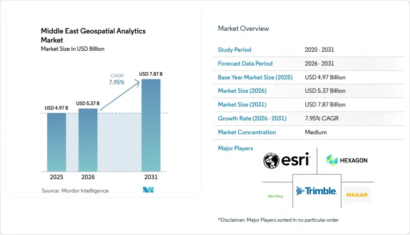
Mordor Intelligence에 의하면, 중동의 지리공간 분석 시장 규모는 2025년에 49억 7,000만 달러로 평가되었고 2026년 53억 7,000만 달러에서 2031년까지 78억 7,000만 달러에 이를 것으로 예측되며, 예측 기간(2026-2031년) CAGR은 7.95%를 나타낼 전망입니다.
본 보고서는 구성 요소(솔루션 및 서비스), 분석 유형(기술적 분석, 진단적 분석 등), 도입 형태(On-Premise, 클라우드,엣지/하이브리드), 용도(지표 및 지형 분석, 네트워크 및 경로 분석 등), 최종 사용자 산업(국방·정보 기관, 정부·지자체 등), 그리고 국가별로 분류되어 있습니다.
중동 지리공간 분석 시장 동향 및 인사이트
GCC 전역에서 급증하는 스마트 시티 프로그램
걸프 연안 국가들의 메가 프로젝트에서는 도시 관리 아키텍처에 지리공간 분석이 통합되어 있습니다. 두바이의 ‘2040 도시 마스터플랜’에서는 녹지 면적을 두 배로 늘리는 동시에 인구 780만 명을 목표로 하고 있으며, ‘20분 도시’라는 개념을 실현하기 위해 실시간 공간 모델링이 요구되고 있습니다. 사우디아라비아와 네이버의 제휴를 통해 리야드 및 기타 4개 도시에 해상도 10cm의 3D 트윈이 제공되어, 홍수 시뮬레이션 및 인프라 최적화가 가능해졌습니다. UAE의 25억 달러 규모 ‘Aion Sentia’ 플랫폼은 AI를 활용한 공간 데이터를 통합하여 도시 서비스를 종단 간(end-to-end)으로 조정하고 있습니다. 이러한 프로젝트를 통해 중동 지리공간 분석 시장에서 대량의 이미지 수집, 고도화된 경로 분석, 예측 유지보수 모델에 대한 예측 가능한 다년간 수요가 창출되고 있습니다.
위성을 활용한 지적 현대화 의무화
새로운 토지등기법에서는 서브미터급 정확도와 감사 추적이 의무화되어 있어, 각 기관은 클라우드 기반 공간 데이터 인프라로의 전환을 강요받고 있습니다. 사우디아라비아의 ‘세계 AI 허브 법’ 초안에서는 ‘프라이빗’,‘확장’, ‘가상’ 허브가 규정되어 있어, 주권에 기반한 호스팅을 공식적으로 정하는 동시에 국경을 초월한 지적 정보의 통합을 가능하게 하고 있습니다. UAE의 MBZ-SAT는 국내 지구관측 능력을 향상시키고, 구획 데이터베이스의 갱신 주기를 가속화할 것입니다. 쿠웨이트는 하류 단계에서의 가치를 입증하고 있습니다. 쿠웨이트 유틸리티부는 GIS 워크플로우에 지적 레이어를 통합함으로써 서비스 연결에 소요되는 시간을 단축했습니다. 표준화된 지적 베이스맵을 통해 과세, 인프라 계획, 환경 모니터링 분야에서 보다 심층적인 분석이 가능해집니다.
지리공간 데이터 주권에 관한 규제
분산된 현지화 요건은 다국적 기업의 사업 전개 과정에서 규정 준수 부담을 가중시키고 있습니다. 사우디아라비아의 ‘세계 AI 허브 법’ 초안은 감사 의무가 서로 다른 세 가지 명확한 호스팅 모델을 규정하고 있어, 지역 데이터 레이크 아키텍처를 복잡하게 만들고 있습니다. UAE의 현지화 규정에 따라 외국 공급업체는 현지 거점 구축이나 합작 투자 참여를 강요받고 있어 도입 기간이 장기화되고 있습니다. 걸프 지역에서 중국 하이퍼스케일러의 확장이 격화되는 가운데, 플랫폼 선정 및 암호화 기준에 대한 지정학적 감시가 강화되고 있습니다. 이러한 동향으로 인해 중동 지리공간 분석 시장에서 중소 벤더들은 어려운 상황에 내몰리고 있으며, 조달 주기가 장기화되고 있습니다.
부문 분석
2025년, 중동의 지리공간 분석 시장에서 솔루션은 68.60%의 점유율을 차지하며 계속해서 시장을 독점했습니다. 이는 소프트웨어 제품군 및 센서 하드웨어에 대한 꾸준한 투자를 반영한 것입니다. 그러나 정부 부처와 기업들이 통합, 모델 훈련, 연중무휴 24시간 관리형 분석 서비스를 외부에 위탁하는 경향이 강해짐에 따라, 서비스 부문은 연평균 성장률(CAGR) 11.05%로 확대되고 있습니다. 지역 내 딥러닝 GIS 전문가 부족으로 인해, 벤더가 제공하는 전문 서비스는 신속한 도입을 실현하기 위한 현실적인 수단이 되고 있습니다. 정부는 데이터 수집 파이프라인, 주권형 클라우드 호스팅, 아랍어 인터페이스를 통합한 턴키형 프레임워크를 선호하고 있습니다.
서비스 제공업체들은 전략적 제휴를 활용하여 각 산업 분야와의 유대를 강화하고 있습니다. 벤틀리 시스템즈는 구글의 지리 공간 컨텐츠를 통합하고 디지털 트윈 워크플로우 내에서 보다 풍부한 컨텍스트를 제공함으로써 인프라 서비스(IaaS) 제공을 지원하고 있습니다. 관리형 서비스 포트폴리오에는 현재 위성 이미지의 지속적인 업데이트, AI 모델 재학습, 사이버 복원력 감사가 포함되어 있습니다. 중동 지리공간 분석 시장이 사내 역량 구축보다 속도를 우선시하는 가운데, 이러한 진화를 통해 서비스 부문은 증가하는 운영 비용(OPEX) 예산을 확보할 수 있는 입지에 서게 되었습니다.
기술적 분석은 토지, 자산, 인구 데이터 세트를 아우르는 대시보드와 과거 패턴 인식을 제공함으로써 2025년에도 매출 점유율 43.25%를 유지했습니다. 한편, 처방적 분석은 교통 조정, 에너지 부하 분산, 긴급 대응 경로 설정에 대한 자동 최적화 수요에 힘입어 연평균 10.28%의 성장률을 기록하고 있습니다. 방위 산업 컨글로머릿인 EDGE사는 미션 크리티컬한 작전 활동을 추천하고 자동으로 실행할 수 있는 AI 기반 지리공간 플랫폼을 발표하며, 행동 지향적 엔진으로의 전환이 가속화되고 있음을 부각시켰습니다.
조직은 기술적 분석에서 시작하여 예측적, 진단적, 그리고 최종적으로 처방적 분석으로 진화하는 성숙도 곡선을 따르고 있으며, 예산 배분에서는 후자의 단계가 점점 더 우선시되고 있습니다. AI의 설명 가능성에 대한 신뢰와 5G 엣지 연결의 결합으로 의사결정 주기가 몇 분에서 몇 초로 단축되어, 중동 지리공간 분석 시장에서 고부가가치 분석 계층 시장 침투가 촉진되고 있습니다.
기타 혜택:
- 엑셀 형식 시장 전망(ME) 시트
- 3개월간의 애널리스트 지원
자주 묻는 질문
목차
제1장 서론
제2장 조사 방법
제3장 개요
제4장 시장 구도
제5장 시장 규모와 성장 예측
제6장 경쟁 구도
제7장 시장 기회와 향후의 동향
JHS 26.09.03According to Mordor Intelligence, the Middle East geospatial analytics market size was valued at USD 4.97 billion in 2025 and estimated to grow from USD 5.37 billion in 2026 to reach USD 7.87 billion by 2031, at a CAGR of 7.95% during the forecast period (2026-2031).
This report is Segmented by Component (Solutions and Services), Analytics Type (Descriptive Analytics, Diagnostic Analytics, and More), Deployment Mode (On-Premise, Cloud, and Edge/Hybrid), Application (Surface and Terrain Analysis, Network and Route Analysis, and More), End-User Industry (Defense and Intelligence, Government and Municipalities, and More), and Country.
Middle East Geospatial Analytics Market Trends and Insights
Surging Smart-City Programs Across GCC
Gulf megaprojects are hard-wiring geospatial analytics into urban-management architectures. Dubai's 2040 Urban Master Plan doubles green areas while targeting a population of 7.8 million, demanding real-time spatial modelling for the "20-minute city" concept. Saudi Arabia's partnership with Naver is delivering 10-cm resolution 3-D twins for Riyadh and four additional cities, enabling flood simulation and infrastructure optimisation. The USD 2.5 billion Aion Sentia platform in the UAE integrates AI-driven spatial data to orchestrate city services end-to-end. These projects create predictable, multi-year demand for high-volume imagery ingestion, advanced routing analytics, and predictive maintenance models inside the Middle East geospatial analytics market.
Mandated Satellite-Based Cadastral Modernization
New land-registration statutes require sub-meter accuracy and audit trails, pushing agencies toward cloud-enabled spatial data infrastructures. Saudi Arabia's draft Global AI Hub Law outlines "Private," "Extended," and "Virtual" hubs, formalising sovereign hosting while enabling cross-border cadastral integration. The UAE's MBZ-SAT will lift domestic earth-observation capacity, accelerating update cycles for parcel databases. Kuwait demonstrates downstream value: its utilities ministry cut service-connection times after embedding cadastral layers into a GIS workflow. Standardised cadastral basemaps unlock richer analytics in taxation, infrastructure planning, and environmental monitoring.
Geospatial-Data Sovereignty Regulations
Fragmented localisation mandates elevate compliance overheads for multinational deployments. Saudi Arabia's draft Global AI Hub Law prescribes three distinct hosting archetypes with divergent audit obligations, complicating regional data-lake architectures. The UAE's localisation rules force foreign providers to build local points of presence or enter joint ventures, lengthening deployment timelines. Intensifying Chinese hyperscaler expansion in the Gulf introduces geopolitical scrutiny over platform selection and encryption standards. These dynamics squeeze smaller vendors and prolong procurement cycles within the Middle East geospatial analytics market.
Other drivers and restraints analyzed in the detailed report include:
- Rapid Cloud-GIS Migration by Utilities
- 5G-Enabled Edge Analytics Roll-Outs
- Skilled-Talent Shortage for Deep-Learning GIS
For complete list of drivers and restraints, kindly check the Table Of Contents.
Segment Analysis
Solutions continued to dominate the Middle East geospatial analytics market with a 68.60% share in 2025, reflecting entrenched investments in software suites and sensor hardware. However, the services segment is expanding at an 11.05% CAGR as ministries and enterprises outsource integration, model training, and 24/7 managed analytics. Regional shortages in deep-learning GIS specialists make vendor-delivered professional services the pragmatic route for rapid roll-out. Governments favour turnkey frameworks that bundle data-ingestion pipelines, sovereign cloud hosting, and Arabic language interfaces.
Service providers leverage strategic alliances to deepen vertical intimacy. Bentley Systems integrated Google geospatial content to deliver richer context within digital-twin workflows, underpinning infrastructure-as-a-service offerings. Managed-service portfolios now include continuous satellite imagery updates, AI model retraining, and cyber-resilience audits. This evolution positions the services cohort to capture rising OPEX budgets as the Middle East geospatial analytics market prioritises speed over in-house capability building.
Descriptive analytics retained 43.25% revenue share in 2025 by providing dashboards and historical pattern recognition across land, asset, and population datasets. Yet prescriptive analytics is growing 10.28% annually, propelled by demand for automated optimisation in traffic orchestration, energy load balancing, and emergency-response routing. Defence conglomerate EDGE unveiled an AI-enabled geospatial platform able to recommend and auto-execute mission-critical manoeuvres, underscoring momentum toward action-oriented engines.
Organisations move through a maturity curve starting with descriptive and evolving to predictive, diagnostic, and finally prescriptive; budget allocations increasingly prioritise the latter stages. Confidence in AI explainability, combined with 5G edge connectivity, allows decision loops to compress from minutes to seconds, boosting market penetration for higher-value analytics tiers within the Middle East geospatial analytics market.
Complete Report Scope:
- By Component
- Solutions
- Services
- By Analytics Type
- Descriptive Analytics
- Diagnostic Analytics
- Predictive Analytics
- Prescriptive Analytics
- By Deployment Mode
- On-premise
- Cloud
- Edge/Hybrid
- By Application
- Surface and Terrain Analysis
- Network and Route Analysis
- Geovisualization and 3-D Modelling
- Imagery and Remote-Sensing Analytics
- By End-user Industry
- Defense and Intelligence
- Government and Municipalities
- Utilities and Energy
- Agriculture and Environment
- Transportation and Logistics
- Real Estate and Construction
- Mining and Natural Resources
- Healthcare and Public Health
- Other End-user Industries
- By Country
- United Arab Emirates
- Saudi Arabia
- Turkey
- Qatar
- Oman
- Rest of Middle East
List of Companies Covered in this Report:
- Esri Inc.
- Hexagon AB
- Trimble Inc.
- Bentley Systems Inc.
- Maxar Technologies
- HERE Technologies
- CARTO
- Planet Labs PBC
- Space Imaging Middle East
- Openware
- MindEarth AI
- Alteryx Inc.
- Oracle Corporation
- Google LLC (Alphabet)
- Microsoft Corp.
- AWS (Amazon Web Services)
- IBM Corporation
- SAP SE
- TomTom N.V.
- Fugro N.V.
- BlackSky Technology Inc.
- Airbus Defence & Space
- Harris Geospatial Solutions
- Eos Data Analytics
- AtkinsRealis
Additional Benefits:
- The market estimate (ME) sheet in Excel format
- 3 months of analyst support
TABLE OF CONTENTS
1 INTRODUCTION
- 1.1 Study Assumptions and Market Definition
- 1.2 Scope of the Study
2 RESEARCH METHODOLOGY
3 EXECUTIVE SUMMARY
4 MARKET LANDSCAPE
- 4.1 Market Overview
- 4.2 Market Drivers
- 4.2.1 Surging smart-city programs across GCC
- 4.2.2 Mandated satellite-based cadastral modernization
- 4.2.3 Rapid cloud-GIS migration by utilities
- 4.2.4 5G-enabled edge analytics roll-outs
- 4.2.5 Rise of geo-AI startups in UAE free zones
- 4.2.6 Oil-to-non-oil economic diversification projects
- 4.3 Market Restraints
- 4.3.1 Geospatial-data sovereignty regulations
- 4.3.2 Skilled-talent shortage for deep-learning GIS
- 4.3.3 Fragmented legacy cadastral datasets
- 4.3.4 High LiDAR and SAR acquisition costs
- 4.4 Industry Value Chain Analysis
- 4.5 Regulatory Landscape
- 4.6 Technological Outlook
- 4.7 Industry Attractiveness - Porter's Five Forces Analysis
- 4.7.1 Bargaining Power of Buyers
- 4.7.2 Bargaining Power of Suppliers
- 4.7.3 Threat of New Entrants
- 4.7.4 Threat of Substitutes
- 4.7.5 Intensity of Competitive Rivalry
- 4.8 Impact of Macroeconomic Factors on the Market
5 MARKET SIZE AND GROWTH FORECASTS (VALUES)
- 5.1 By Component
- 5.1.1 Solutions
- 5.1.2 Services
- 5.2 By Analytics Type
- 5.2.1 Descriptive Analytics
- 5.2.2 Diagnostic Analytics
- 5.2.3 Predictive Analytics
- 5.2.4 Prescriptive Analytics
- 5.3 By Deployment Mode
- 5.3.1 On-premise
- 5.3.2 Cloud
- 5.3.3 Edge/Hybrid
- 5.4 By Application
- 5.4.1 Surface and Terrain Analysis
- 5.4.2 Network and Route Analysis
- 5.4.3 Geovisualization and 3-D Modelling
- 5.4.4 Imagery and Remote-Sensing Analytics
- 5.5 By End-user Industry
- 5.5.1 Defense and Intelligence
- 5.5.2 Government and Municipalities
- 5.5.3 Utilities and Energy
- 5.5.4 Agriculture and Environment
- 5.5.5 Transportation and Logistics
- 5.5.6 Real Estate and Construction
- 5.5.7 Mining and Natural Resources
- 5.5.8 Healthcare and Public Health
- 5.5.9 Other End-user Industries
- 5.6 By Country
- 5.6.1 United Arab Emirates
- 5.6.2 Saudi Arabia
- 5.6.3 Turkey
- 5.6.4 Qatar
- 5.6.5 Oman
- 5.6.6 Rest of Middle East
6 COMPETITIVE LANDSCAPE
- 6.1 Market Concentration
- 6.2 Strategic Moves
- 6.3 Market Share Analysis
- 6.4 Company Profiles (includes Global level Overview, Market level overview, Core Segments, Financials as available, Strategic Information, Market Rank/Share for key companies, Products and Services, and Recent Developments)
- 6.4.1 Esri Inc.
- 6.4.2 Hexagon AB
- 6.4.3 Trimble Inc.
- 6.4.4 Bentley Systems Inc.
- 6.4.5 Maxar Technologies
- 6.4.6 HERE Technologies
- 6.4.7 CARTO
- 6.4.8 Planet Labs PBC
- 6.4.9 Space Imaging Middle East
- 6.4.10 Openware
- 6.4.11 MindEarth AI
- 6.4.12 Alteryx Inc.
- 6.4.13 Oracle Corporation
- 6.4.14 Google LLC (Alphabet)
- 6.4.15 Microsoft Corp.
- 6.4.16 AWS (Amazon Web Services)
- 6.4.17 IBM Corporation
- 6.4.18 SAP SE
- 6.4.19 TomTom N.V.
- 6.4.20 Fugro N.V.
- 6.4.21 BlackSky Technology Inc.
- 6.4.22 Airbus Defence & Space
- 6.4.23 Harris Geospatial Solutions
- 6.4.24 Eos Data Analytics
- 6.4.25 AtkinsRealis
7 MARKET OPPORTUNITIES AND FUTURE TRENDS
- 7.1 White-Space and Unmet-Need Assessment


