

|
시장보고서
상품코드
2119645
ANZ의 지리공간 분석 : 시장 점유율 분석, 업계 동향과 통계, 성장 예측(2026-2031년)ANZ Geospatial Analytics - Market Share Analysis, Industry Trends & Statistics, Growth Forecasts (2026 - 2031) |
||||||
 Mordor Intelligence
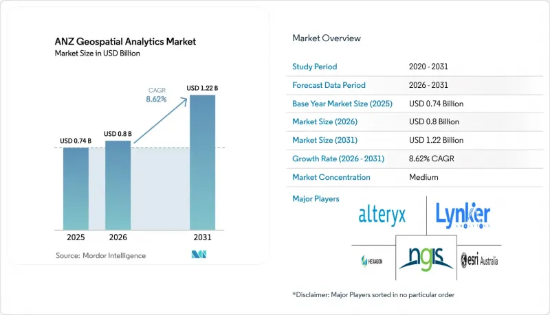
Mordor Intelligence에 따르면 ANZ의 지리공간 분석 시장 규모는 2025년 7억 4,000만 달러에서 2026년에는 8억 달러로 확대되고, 2026년부터 2031년까지 CAGR 8.62%를 기록하며 2031년에는 12억 2,000만 달러에 달할 것으로 예측됩니다.
본 보고서는 유형(지표면 분석, 네트워크 분석, 지리 시각화), 최종사용자 산업(농업, 공공사업·통신, 국방·정보, 정부, 광업·천연자원, 자동차·운송, 의료, 부동산·건설, 기타) 및 국가별로 분류되어 있습니다. 시장 예측은 금액(달러)으로 표시되어 있습니다.
ANZ 지리공간 분석 시장의 동향 및 인사이트
AI/ML 도입으로 GIS의 주류화가 가속화
현재 호주·뉴질랜드(ANZ)의 지리공간 분석 시장에서 인공지능(AI)과 기계학습(ML)이 GIS의 주요 워크플로를 뒷받침하며, 수작업에 따른 처리 시간 단축과 실시간 의사결정 지원을 실현하고 있습니다. BHP의 디지털 트윈은 3기가리터 이상의 물과 118 GWh의 에너지를 절약하고 있으며, 구체적인 지속가능성 성과를 부각시키고 있습니다. GeoAI의 매출은 2024년부터 2029년 사이에 전 세계적으로 4배 증가할 것으로 예측되며, 이러한 전망에 따라 플랫폼 공급업체들은 사전 학습된 모델과 노코드 AI 파이프라인의 통합을 추진하고 있습니다. 대학들도 이러한 추세를 뒷받침하고 있습니다. 시드니 대학의 토양 수분 도구는 위성 이미지와 센서 데이터를 80m²의 해상도로 통합하여 관개 일정을 미세 조정하고 있습니다.
스마트 시티 및 디지털 트윈 프로그램이 인프라 투자를 주도
빅토리아주와 뉴사우스웨일스주의 주 차원 프로그램에서는 교통 계획 및 재난 관리를 위한 몰입형 4D 모델을 구축하기 위해 7,700만 달러 이상이 배정되었습니다. 웰링턴의 디지털 트윈은 교통량, 항공 교통 패턴, IoT 센서 데이터를 중첩하여 당국자들이 건설 전에 제안된 교량의 영향을 시각화할 수 있도록 합니다. 민간 개발업체들도 혜택을 보고 있습니다. Lendlease에 따르면, 디지털 트윈이 일정 수립 의사결정을 주도함으로써 비용을 20% 절감하고 시장 출시까지 걸리는 시간을 100분의 1로 단축할 수 있는 잠재력이 있습니다.
플랫폼 및 데이터 라이선싱 비용이 높아 중소기업의 도입을 저해하고 있습니다.
엔터프라이즈급 GIS 제품군의 경우, 초기 라이선스 비용이 1만 1,500달러를 초과하고 연간 구독료로 3,800달러 이상이 추가로 발생하기 때문에 소규모 계약업체나 지자체에게는 장벽이 되고 있습니다. 클라우드 호스팅의 경우, 스토리지 및 대역폭에 따라 변동적인 추가 요금이 발생하기 때문에 예산 계획을 예측하기 어려워져, 개념 증명(PoC) 파일럿 프로젝트가 정체되는 경우가 많습니다. 이에 대한 경쟁사의 대응책으로 Euclideon의 구독형 3D 데이터 허브를 들 수 있습니다. 이는 무료 뷰어를 번들로 제공함으로써 도입 장벽을 낮추고 있습니다. 그러나 가격 투명성이 개선될 때까지는 많은 중소기업이 디지털 트윈의 전면적인 도입을 미루고 있으며, 이로 인해 ANZ 지역의 지리 공간 분석 시장의 단기적인 성장이 둔화되고 있습니다.
부문 분석
2025년, 시장에서 솔루션이 62.40%라는 최대 점유율을 차지했습니다. 이는 일상적인 매핑, 자산 추적, 규제 보고를 지원하는 확고한 플랫폼에 대한 투자가 뒷받침된 결과입니다. 한편, 관리형 서비스는 연평균 성장률(CAGR) 16.9%로 성장하고 있습니다. 이는 조직들이 영구 라이선스보다 예측 가능한 운영 비용(OPEX)을 선호하는 경향이 있으며, 아웃소싱이 인력 부족을 보완할 수 있다는 점을 인식하고 있기 때문입니다. Esri Australia의 클라우드 호스팅형 관리형 GIS는 이 모델의 대표적인 예로, SOC2 준수 보안은 물론 현지 헬프데스크 지원을 제공함으로써 사내 팀이 일상적인 패치 적용 및 확장성 관리 업무에서 해방되도록 돕고 있습니다.
서비스 공급업체들은 현재 지속적인 최적화, DevOps 파이프라인 및 교육을 패키지로 묶어, 단순한 프로젝트 수주업체에서 디지털 트윈 로드맵을 주도하는 전략적 파트너로 변모하고 있습니다. 이러한 추세에 따라 데이터 과학자, UX 디자이너, 도메인 컨설턴트 등 다양한 분야의 인재를 보유하고, 분산된 데이터세트를 통합적인 의사결정 지원 엔진으로 엮어내는 기업으로 경쟁 우위가 이동하고 있습니다. 그 결과, 시장에서는 솔루션 소유에서 구독형 생태계로의 전환이 가속화되고 있으며, 이러한 추세는 Trimble의 소프트웨어 매출 비중 75% 및 연간 반복 수익 22억 6,000만 달러로 입증되고 있습니다.
2025년에도 온프레미스 도입에 의한 매출 비율은 47.10%를 유지했습니다. 이는 광업, 국방, 공공 사업과 같은 분야에서 기밀성이 높은 지리 데이터에 대한 자율적인 관리가 우선시되고 있기 때문입니다. 그러나 클라우드 부문의 연평균 성장률(CAGR)이 21%에 달한다는 사실은 하이퍼스케일 환경의 내결함성과 비용 탄력성에 대한 신뢰가 높아지고 있음을 보여줍니다. ArcGIS Online의 99.9% 가동률 보장은 멀티 클라우드 간 이식성과 결합되어, 중복 데이터센터를 구축하지 않고도 관할 구역을 넘나드는 협력을 추구하는 기관에게 매력적입니다.
하이브리드 배포는 위험과 민첩성 간의 균형을 맞추며, 조직이 AI 훈련이나 테라바이트 규모의 렌더링을 위해 클라우드로 버스트되는 워크로드를 컨테이너화하면서도 가장 중요한 계층은 온프레미스에 유지할 수 있게 해줍니다. 정부의 광섬유망 구축과 SouthPAN의 정확도 향상으로 지연 제약이 더욱 완화되어, 공중 네트워크를 통해 고해상도 고도 모델이나 드론의 실시간 영상을 스트리밍하는 것이 현실화되고 있습니다. 그 결과, 시장에서 아키텍처의 전환이 나타나고 있습니다. 클라우드 네이티브 마이크로서비스가 데이터 수집, 분석, 시각화 파이프라인을 처리하는 한편, 기존의 온프레미스 클러스터는 스테이징 영역이나 데이터 주권을 보장하는 저장소로서의 역할을 맡게 됩니다.
기타 혜택:
- 엑셀 형식의 시장 예측(ME) 시트
- 3개월간의 애널리스트 지원
자주 묻는 질문
목차
제1장 소개
제2장 조사 방법
제3장 주요 요약
제4장 시장 구도
제5장 시장 규모와 성장 예측
제6장 경쟁 구도
제7장 시장 기회와 향후 전망
제8장 투자 분석
KSM 26.09.03According to Mordor Intelligence, the ANZ geospatial analytics market size is expected to grow from USD 0.74 billion in 2025 to USD 0.8 billion in 2026 and is forecast to reach USD 1.22 billion by 2031 at 8.62% CAGR over 2026-2031.
This report is Segmented by Type (Surface Analysis, Network Analysis, Geovisualization), by End-User Vertical (Agriculture, Utility and Communication, Defense and Intelligence, Government, Mining and Natural Resources, Automotive and Transportation, Healthcare, Real Estate and Construction, Other End-User Verticals), and by Country. The Market Forecasts are Provided in Terms of Value (USD).
ANZ Geospatial Analytics Market Trends and Insights
AI/ML Infusion Accelerates Mainstream GIS Adoption
Artificial intelligence and machine learning now underpin core GIS workflows across the ANZ geospatial analytics market, reducing manual processing times and enabling real-time decision support. BHP's digital twins conserve more than 3 gigaliters of water and 118 GWh of energy, highlighting tangible sustainability outcomes. GeoAI revenue is forecast to quadruple globally between 2024 and 2029, an outlook that encourages platform vendors to embed pre-trained models and no-code AI pipelines. Universities bolster this trend; the University of Sydney's soil-moisture tool merges satellite imagery with sensor feeds at 80 m2 resolution to fine-tune irrigation scheduling. Natural-language GIS copilots are appearing, letting planners pose queries such as "Highlight parcels with flood risk above
Smart-City and Digital-Twin Programs Drive Infrastructure Investment
State-level programs in Victoria and New South Wales allocate more than USD 77 million to create immersive 4D models for transport planning and hazard management. Wellington's Digital Twin layers traffic counts, air-traffic patterns, and IoT sensor data so officials can visualize the effect of proposed bridges before construction. Private developers also gain; Lendlease reports potential 20% cost savings and 100-fold speed-to-market improvements when digital twins guide scheduling decisions.
High Platform and Data Licensing Costs Constrain SME Adoption
Enterprise-grade GIS suites command initial license fees exceeding USD 11,500 plus annual subscriptions above USD 3,800, a hurdle for small contractors and councils . Cloud hosting adds variable storage and bandwidth surcharges that make budgeting unpredictable, often stalling proof-of-concept pilots. Competitive responses include Euclideon's subscription-based 3D data hub that bundles free viewers to lower entry frictio. Yet until price transparency improves, many SMEs postpone full digital-twin rollouts, tempering near-term expansion of the ANZ geospatial analytics market.
Other drivers and restraints analyzed in the detailed report include:
- Post-COVID Infrastructure Stimulus Fuels Geospatial Capital Expenditure
- Mandatory Spatial-Data Reporting Transforms Compliance Workflows
- Shortfall of Geospatial Data-Science Talent Threatens Growth
For complete list of drivers and restraints, kindly check the Table Of Contents.
Segment Analysis
Solutions generated the largest slice of the ANZ geospatial analytics market in 2025 at 62.40%, buoyed by entrenched platform investments that underpin day-to-day mapping, asset tracking, and regulatory reporting. Managed services, however, are climbing at 16.9% CAGR because organizations favor predictable OPEX over perpetual licenses and recognize that outsourcing bridges the talent shortfall. Esri Australia's cloud-hosted managed GIS exemplifies the model, offering SOC2-aligned security plus local help-desk support that frees internal teams from routine patching and scalability chores.
Service vendors now bundle continuous optimization, DevOps pipelines, and training, transforming from project contractors into strategic partners that shepherd digital-twin roadmaps. This dynamic shifts competitive advantage toward firms with multidisciplinary benches data scientists, UX designers, and domain consultants who knit disparate datasets into cohesive decision-support engines. As a result, the ANZ geospatial analytics market sees accelerating migration from solution ownership toward subscription-based ecosystems, a trend reinforced by Trimble's 75% software revenue mix and USD 2.26 billion in annualized recurring revenue.
On-premise installations retained 47.10% revenue in 2025 because mining, defense, and utilities prioritize sovereign control over sensitive geodata. Yet the cloud segment's 21% CAGR underscores growing confidence in hyperscale resilience and cost elasticity. ArcGIS Online's 99.9% uptime pledge, paired with multicloud portability, appeals to agencies seeking cross-jurisdiction collaboration without building redundant data centers.
Hybrid deployments bridge risk and agility, letting organizations containerize workloads that burst to the cloud for AI training or terabyte-scale rendering while retaining crown-jewel layers on site. Government fiber rollouts and SouthPAN accuracy upgrades further erode latency constraints, making it feasible to stream high-resolution elevation models or live drone feeds over public networks. Consequently, the ANZ geospatial analytics market observes an architectural pivot: cloud-native micro-services handle ingest, analytics, and visualization pipelines, whereas legacy on-prem clusters become staging areas or data-sovereignty vaults.
Complete Report Scope:
- By Component
- Solutions
- Services
- By Deployment Model
- On-premise
- Cloud
- Hybrid
- By Analytics Technique
- Descriptive
- Predictive
- Prescriptive
- By Type
- Surface Analysis
- Network Analysis
- Geovisualization
- By End-user Vertical
- Agriculture
- Utility and Communication
- Defense and Intelligence
- Government
- Mining and Natural Resources
- Automotive and Transportation
- Healthcare
- Real-Estate and Construction
- Other Verticals
- By Country
- Australia
- New Zealand
List of Companies Covered in this Report:
- Esri Australia Pty Ltd
- NGIS Australia Pty Ltd
- Hexagon AB
- Alteryx Inc.
- Lynker Analytics Ltd
- Intermap Technologies Corp.
- Mapizy Pty Ltd
- CoreLogic NZ Ltd
- Abley Ltd
- Geospatial Intelligence Pty Ltd
- Digital Agriculture Services Pty Ltd
- SRA Information Technology Pty Ltd
- Fugro NV
- Nearmap Ltd
- Trimble Inc.
- Maxar Technologies Inc.
- Google Australia Pty Ltd (Google Cloud Geo)
- Jacobs Group (Australia) Pty Ltd
- Woolpert Australia Pty Ltd
- FrontierSI Ltd
Additional Benefits:
- The market estimate (ME) sheet in Excel format
- 3 months of analyst support
TABLE OF CONTENTS
1 INTRODUCTION
- 1.1 Study Assumptions and Market Definition
- 1.2 Scope of the Study
2 RESEARCH METHODOLOGY
3 EXECUTIVE SUMMARY
4 MARKET LANDSCAPE
- 4.1 Market Overview
- 4.2 Market Drivers
- 4.2.1 Growing demand from smart-city and digital-twin programs
- 4.2.2 AI/ML infusion into mainstream GIS workflows
- 4.2.3 Post-COVID infrastructure stimulus fuelling geospatial capex
- 4.2.4 Mandatory spatial-data reporting in mining and agriculture
- 4.2.5 Precision-ag ''paddock-level'' decision support requirements
- 4.2.6 Carbon-credit verification using earth-observation datasets
- 4.3 Market Restraints
- 4.3.1 High platform and data licensing costs
- 4.3.2 Fragmented spatial-data standards between AU and NZ
- 4.3.3 Shortfall of geospatial data-science talent
- 4.3.4 Public backlash over location-privacy breaches
- 4.4 Value Chain Analysis
- 4.5 Regulatory Landscape
- 4.6 Technological Outlook
- 4.6.1 Cloud-Native GeoAI Pipelines
- 4.7 Porter's Five Forces
- 4.7.1 Bargaining Power of Buyers
- 4.7.2 Bargaining Power of Suppliers
- 4.7.3 Threat of New Entrants
- 4.7.4 Threat of Substitutes
- 4.7.5 Intensity of Competitive Rivalry
5 MARKET SIZE AND GROWTH FORECASTS (VALUE)
- 5.1 By Component
- 5.1.1 Solutions
- 5.1.2 Services
- 5.2 By Deployment Model
- 5.2.1 On-premise
- 5.2.2 Cloud
- 5.2.3 Hybrid
- 5.3 By Analytics Technique
- 5.3.1 Descriptive
- 5.3.2 Predictive
- 5.3.3 Prescriptive
- 5.4 By Type
- 5.4.1 Surface Analysis
- 5.4.2 Network Analysis
- 5.4.3 Geovisualization
- 5.5 By End-user Vertical
- 5.5.1 Agriculture
- 5.5.2 Utility and Communication
- 5.5.3 Defense and Intelligence
- 5.5.4 Government
- 5.5.5 Mining and Natural Resources
- 5.5.6 Automotive and Transportation
- 5.5.7 Healthcare
- 5.5.8 Real-Estate and Construction
- 5.5.9 Other Verticals
- 5.6 By Country
- 5.6.1 Australia
- 5.6.2 New Zealand
6 COMPETITIVE LANDSCAPE
- 6.1 Market Concentration
- 6.2 Strategic Moves
- 6.3 Market Share Analysis
- 6.4 Company Profiles (includes Global level overview, Market level overview, Core segments, Financials as available, Strategic information, Market Rank/Share, Products & Services, Recent Developments)
- 6.4.1 Esri Australia Pty Ltd
- 6.4.2 NGIS Australia Pty Ltd
- 6.4.3 Hexagon AB
- 6.4.4 Alteryx Inc.
- 6.4.5 Lynker Analytics Ltd
- 6.4.6 Intermap Technologies Corp.
- 6.4.7 Mapizy Pty Ltd
- 6.4.8 CoreLogic NZ Ltd
- 6.4.9 Abley Ltd
- 6.4.10 Geospatial Intelligence Pty Ltd
- 6.4.11 Digital Agriculture Services Pty Ltd
- 6.4.12 SRA Information Technology Pty Ltd
- 6.4.13 Fugro NV
- 6.4.14 Nearmap Ltd
- 6.4.15 Trimble Inc.
- 6.4.16 Maxar Technologies Inc.
- 6.4.17 Google Australia Pty Ltd (Google Cloud Geo)
- 6.4.18 Jacobs Group (Australia) Pty Ltd
- 6.4.19 Woolpert Australia Pty Ltd
- 6.4.20 FrontierSI Ltd
7 Market Opportunities and Future Outlook
- 7.1 White-space and Unmet-need Assessment


