|
시장보고서
상품코드
2121873
중동 및 아프리카의 LiDAR 시장 : 시장 점유율 분석, 업계 동향 및 통계, 성장 예측(2026-2031년)Middle East And Africa LiDAR - Market Share Analysis, Industry Trends & Statistics, Growth Forecasts (2026 - 2031) |
||||||
 Mordor Intelligence
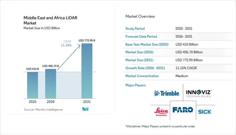
Mordor Intelligence에 의하면, 중동 및 아프리카의 LiDAR 시장 규모는 2025년 4억 1,000만 달러로 평가되었고, 2026년에는 4억 5,570만 달러로 추정되고, 2026-2031년 CAGR 11.15%로 성장을 지속할 전망이며, 2031년에는 7억 7,290만 달러에 이를 것으로 예측됩니다.
본 보고서는 제품별(항공 LiDAR, 지상형 등), 기술별(비행시간법, 가이거 모드 등), 구성 요소별(레이저 스캐너, GPS 등), 도입 플랫폼별(UAV 기반 등), 측정 범위별(단거리 등), 최종 이용 산업(엔지니어링 등), 국가별(사우디아라비아 등)로 분류되어 있습니다. 시장 규모 및 전망은 금액(달러)으로 표시되어 있습니다.
중동 및 아프리카의 라이더 시장 동향 및 인사이트
GCC 지역 내 스마트 시티 디지털 트윈 구축을 위한 LiDAR 도입 의무화
현재 걸프 연안 국가 정부들은 도시 자산에 대해 1센티미터 미만의 정밀도를 가진 디지털 복제를 의무화하고 있으며, 이에 따라 LiDAR는 지하 매설물 매핑, 교통 흐름 최적화 및 탄소 발자국 분석에 필수적인 요소가 되었습니다. 두바이 시 당국은 매설된 배관 및 케이블 모델링에 모바일 스캐너를 활용하여 예기치 않은 정전 및 굴착 공사 재시공을 줄이고 있습니다. 카타르에서는 루사일 시티를 위한 6,000만 달러 규모의 스마트 시티 플랫폼이 지속적인 LiDAR 데이터를 처리하여 45만 명의 주민에게 서비스를 관리하고 있습니다. 공공 프로젝트에 BIM 도입이 의무화됨에 따라, 라이다(LiDAR) 포인트 클라우드 데이터가 표준화된 건설 모델에 직접 통합되도록 보장되어 데이터 형식으로 인한 병목 현상이 해소되고 있습니다. 그 결과, 허가 승인 절차를 신속하게 처리하고 수명 주기 비용 초과를 줄이는 통합된 계획 접근 방식이 실현되고 있습니다. 또한, GCC(걸프협력회의) 당국은 라이다 조달을 클라우드 분석과 함께 실시하고 있으며, 주권 관련 규정을 준수하는 현지 데이터센터의 활용을 촉진하고 있습니다.
사우디아라비아의 기가 프로젝트에서 UAV 탑재형 회랑 매핑의 급증
NEOM의 170km에 달하는 선형 도시와 같은 주목도 높은 프로젝트에서는 기존 측량 방식으로는 시간 내에 커버할 수 없는 광대한 지역에 대해 매주 지형 데이터 업데이트가 필요합니다. 중거리 LiDAR를 탑재한 회전익 드론은 현재 하루 최대 100에이커를 1-3cm의 정밀도로 매핑하고 있으며, 진행 상황 추적 주기를 70% 단축하고 있습니다. Aeromotus와 같은 전문 업체는 비행 계획,스캔, 클라우드 처리를 결합한 턴키 방식의 ‘드론-어즈-어-서비스(Drone-as-a-Service)’ 패키지를 제공합니다. 이를 통해 생성된 디지털 트윈을 활용함으로써, 시공사는 설계 의도와 완공 시의 상태를 비교하여 토공 작업의 편차를 조기에 발견할 수 있습니다. 고속철도 간선이나 해수 담수화 파이프라인과 같은 선형 인프라의 경우, 회랑 정보를 신속하게 갱신함으로써 변경 지시 빈도를 줄이고 납기 마일스톤을 확실하게 준수할 수 있습니다.
지역 내 교정 실험실 부족으로 리드타임이 길어지고 있다.
리야드와 요하네스버그 사이에는 인증받은 시험소가 극히 적기 때문에 대부분의 사업자는 연례 재교정을 위해 센서를 유럽으로 보내야만 합니다. 물류 지연은 최대 12주까지 이어지기도 하여, 건설 성수기에는 장비 사용이 중단되기도 합니다. 대형 건설사는 ClearSkies Geomatics와 같은 공급업체로부터 사전에 교정된 장비를 임대하여 대응하고 있지만, 중소규모 기업은 작업자를 유휴 상태로 두거나 위약금을 부담할 수밖에 없는 상황에 처해 있습니다. 이러한 병목 현상은 보증 사양을 유지하기 위해 더 짧은 서비스 주기가 필요한 경우가 많은 첨단 솔리드 스테이트 LiDAR의 도입도 방해하고 있습니다. 만안 지역의 일부 자유무역지대에서는 해외 측정 기관이 지점을 개설하도록 장려책을 발표하고 있지만, 일정을 고려할 때 실질적인 처리 능력이 확보되는 것은 2027년 이후가 될 전망입니다.
부문 분석
2025년, 중동 및 아프리카 라이더(LiDAR) 시장 규모의 54.30%를 항공 플랫폼이 차지했습니다. 이는 건조한 지형에 펼쳐진 거대 프로젝트 부지를 측량할 수 있는 능력에 기인합니다. 사우디아라비아의 엔지니어링 기업들은 헬리콥터와 고정익 항공기를 이용한 측량 활동을 통해 매주 토사 채취량과 성토량을 갱신하고, 공사 지연을 경고하는 대시보드에 데이터를 반영하고 있습니다. 사선 사진 측량과 고밀도 포인트 클라우드를 결합함으로써, 기획 담당자는 도로 노선에 영향을 미치는 암반 절삭면이나 사막의 와디를 시각화할 수 있습니다. 또한 나미비아에서는 해안 침식 모니터링에도 항공 스캔이 활용되고 있으며, 녹색 파장의 레이저 펄스를 사용하여 관광 해변을 따라 있는 모래 언덕의 이동을 측정하고 있습니다.
지상형 스캐너 시장 점유율은 아직 작지만, 지자체가 하수도, 교량, 역사적 건축물의 외관을 디지털화하는 움직임에 따라 연평균 성장률(CAGR) 13.76%가 예상됩니다. 웨어러블 시스템은 GPS 없이 다층 터널을 매핑하여, 검사관이 타일 뒷면의 콘크리트 박리 현상을 감지할 수 있게 해줍니다. 중동 및 아프리카의 LiDAR 시장은 스캔 데이터를 실시간으로 등록하는 SLAM 알고리즘의 혜택을 받아, 예전에는 1주일이 걸리던 충돌 감지 보고서를 하룻밤 만에 발행할 수 있게 되었습니다. 하드웨어의 소형화로 인해 현재는 작업자 2명이 하룻밤 만에 지하철 역 전체를 스캔할 수 있게 되어, 대형 건설사뿐만 아니라 더 폭넓은 계층이 고정밀 문서화를 활용할 수 있게 되었습니다.
2025년에도 비행시간법(ToF)은 매출의 62.40%를 차지하며 여전히 주력 기술로서의 위상을 유지했습니다. 이는 아라비아 반도 특유의 모래 먼지가 섞인 바람이나 강한 햇빛의 눈부심 속에서도 견고한 성능을 발휘한다는 점이 높이 평가받고 있습니다. 전력 회사는 송전선로 통로 여유 공간 점검에 ToF 장비를 도입하여, 정유시설의 생산을 중단시킬 수 있는 식생으로 인한 정전을 방지하고 있습니다. 벤더의 로드맵에는 측정 범위를 3km 이상으로 확장하는 눈에 안전한 1,550 nm 레이저가 도입되어 있어 노천 채굴 광산의 사면 분석에서 활용 범위가 확대되고 있습니다.
가이거 모드 센서는 초고밀도 측정 지점을 통해 환경 모델링이 가속화됨에 따라 연평균 성장률(CAGR) 12.85%가 예상됩니다. 가봉의 산림 탄소 프로젝트에서는 이 기술을 활용하여 바이오매스 추정치를 정밀화하고 있으며, 자발적 탄소 시장에서 검증 기준이 엄격해지는 가운데 이는 매력적인 특징으로 작용하고 있습니다. 고고도 운용을 통해 시간당 366 km²의 관측 범위를 실현하여, 항공기 1회 출동으로 전국 규모의 DEM(디지털 고도 모델)을 갱신할 수 있습니다. 압축 센싱에 대한 지속적인 연구를 통해 데이터 양 증가 없이 64배의 해상도 향상이 기대되며, 실시간 홍수 시뮬레이션에 대한 적합성이 향상되고 있습니다.
기타 혜택 :
- 엑셀 형식 시장 예측(ME) 시트
- 3개월간의 애널리스트 지원
자주 묻는 질문
목차
제1장 서론
제2장 조사 방법
제3장 주요 요약
제4장 시장 구도
제5장 시장 규모 및 성장 예측
제6장 경쟁 구도
제7장 시장 기회 및 향후 전망
AJY 26.09.09According to Mordor Intelligence, the Middle East and Africa LiDAR market size is expected to grow from USD 410 million in 2025 to USD 455.7 million in 2026 and is forecast to reach USD 772.9 million by 2031 at 11.15% CAGR over 2026-2031.
This report is Segmented by Product (Aerial LiDAR, Ground-Based and More), Technology (Time-Of-Flight, Geiger-Mode and More), Component (Laser Scanners, GPS and More), Deployment Platform (UAV-Based, and More), Range (Short-Range, and More), End-Use Industry (Engineering, and More), and Country (Saudi Arabia, and More). The Market Size and Forecasts are Provided in Terms of Value (USD).
Middle East And Africa LiDAR Market Trends and Insights
LiDAR Mandate for Smart-City Digital Twins in GCC
Gulf governments now require sub-centimeter digital replicas of city assets, making LiDAR indispensable for underground-utility mapping, traffic-flow optimisation, and carbon-footprint analysis. Dubai Municipality is applying mobile scanners to model buried pipes and cables, cutting unplanned outages and excavation re-works. In Qatar, a USD 60 million smart-city platform for Lusail City processes continuous LiDAR feeds to manage 450,000 residents' services. Mandatory BIM adoption in public projects ensures that LiDAR point clouds flow directly into standardised construction models, removing data-format bottlenecks. The result is a unified planning approach that speeds permit approvals and reduces lifecycle cost overruns. GCC authorities also bundle LiDAR procurement with cloud analytics, encouraging local data-centres that comply with sovereignty rules.
Surge in UAV-Borne Corridor Mapping for Saudi Giga-Projects
High-profile programmes such as NEOM's 170 km linear city require weekly topographic updates over vast tracts that conventional surveys cannot cover in time. Rotary-wing drones equipped with medium-range LiDAR now map up to 100 acres per day at 1-3 cm accuracy, slashing progress-tracking cycles by 70%. Specialist operators like Aeromotus supply turnkey drone-as-a-service packages that combine flight planning, scanning, and cloud processing. Resulting digital twins allow contractors to compare design intent with as-built conditions, catching earthwork deviations early. For linear infrastructure such as high-speed rail spines and desalination pipelines, rapid corridor updates reduce change-order frequency and safeguard delivery milestones.
Scarcity of Regional Calibration Labs Inflating Lead-Times
Only a handful of accredited laboratories exist between Riyadh and Johannesburg, forcing most operators to ship sensors to Europe for annual recalibration. Logistics lags can stretch to 12 weeks, freezing fleet availability during peak construction phases. Larger contractors respond by leasing pre-calibrated units from providers such as ClearSkies Geomatics, while smaller firms idle crews and absorb liquidated damages. The bottleneck also hampers adoption of advanced solid-state LiDAR, which often requires shorter service cycles to uphold warranty specifications. Several Gulf free-zones have announced incentives for foreign metrology houses to open branches, yet timelines suggest meaningful capacity will not arrive before 2027.
Other drivers and restraints analyzed in the detailed report include:
- Offshore Wind-Farm Bathymetry Needs Off Namibia and South Africa
- Security-Driven Perimeter Surveillance at UAE Critical Sites
- Limited GNSS Reference-Station Density Outside Gulf States
For complete list of drivers and restraints, kindly check the Table Of Contents.
Segment Analysis
Aerial platforms generated 54.30% of the Middle East and Africa LiDAR market size in 2025, a position rooted in their ability to survey giga-project footprints that sprawl across arid terrains. Saudi engineering firms rely on helicopter and fixed-wing campaigns to update cut-and-fill quantities weekly, feeding dashboards that flag schedule slippage. The combination of oblique photogrammetry with high-density point clouds helps planners visualise rock-cut faces and desert wadis that influence road alignments. Aerial scanning also underpins coastal-erosion monitoring in Namibia, where green-wavelength laser pulses measure dune migration along tourist beaches.
Ground-based scanners, though holding a smaller share, are slated for 13.76% CAGR as municipalities digitise sewers, bridges, and heritage facades. Wearable systems map multistorey tunnels without GPS, letting inspectors detect spalling concrete behind tiles. The Middle East and Africa LiDAR market benefits from SLAM algorithms that register scans in real time, permitting overnight issuance of clash-detection reports that would once take a week. Hardware miniaturisation means a two-person crew can now capture an entire metro station in an evening, democratising high-precision documentation beyond tier-one contractors.
Time-of-Flight remained the workhorse with 62.40% revenue in 2025, prized for robust performance under dust-laden winds and intense solar glare typical of the Arabian Peninsula. Power utilities employ ToF units for corridor clearance checks on transmission lines, avoiding vegetation-related outages that could stall refinery production. Vendor roadmaps introduce eye-safe 1,550 nm lasers that extend range past 3 km, widening use in open-pit mine slope analysis.
Geiger-mode sensors post a 12.85% CAGR forecast because ultra-high-point densities accelerate environmental modelling. Forestry-carbon projects in Gabon use the technology to refine biomass estimates, an attractive quality as voluntary carbon markets tighten verification standards. Elevated altitude operation supports 366 km2/h coverage, enabling national-scale DEM refreshes on single aircraft sorties. Continued research into compressive sensing promises 64-fold resolution gains without heavier data volumes, enhancing suitability for real-time flood simulations.
Complete Report Scope:
- By Product
- Aerial LiDAR
- Mechanical Scanning
- Solid-state Scanning
- By Technology
- Ground-based LiDAR
- Time-of-Flight
- Geiger-Mode
- Phase-Shift
- Flash LiDAR
- By Component
- Laser Scanners
- GPS/GNSS Receiver
- Inertial Measurement Unit
- Cameras and MEMS Mirrors
- Other Components
- By Deployment Platform
- Terrestrial Static Tripod
- UAV-/Drone-based
- Mobile Mapping (Vehicle-mounted)
- Bathymetric/Airborne Hydrographic
- By Range
- Short-Range
- Medium-Range
- Long-Range
- By End-Use Industry
- Engineering and Construction
- Oil and Gas
- Aerospace and Defense
- Automotive and ADAS
- Mining and Quarrying
- Agriculture and Forestry
- By Country
- Saudi Arabia
- Qatar
- Kuwait
- United Arab Emirates
- South Africa
- Kenya
- Rest of Middle East and Africa
List of Companies Covered in this Report:
- Leica Geosystems AG
- Sick AG
- Ouster Inc.
- Cepton Technologies Inc.
- Hexagon AB
- MENA 3D
- Sandvik Mining and Rock Solutions
- Trimble Inc.
- FARO Technologies Inc.
- RIEGL Laser Measurement Systems
- Quanergy Systems Inc.
- LightWare LiDAR LLC
- GlobalScan Technologies LLC
- Microdrones GmbH
- Innoviz Technologies Ltd
- Velodyne Lidar Inc.
- Teledyne Optech
- Topcon Positioning Group
- Falcon-3D
- Sitech Gulf
- DJI Enterprise
Additional Benefits:
- The market estimate (ME) sheet in Excel format
- 3 months of analyst support
TABLE OF CONTENTS
1 INTRODUCTION
- 1.1 Study Assumptions and Market Definition
- 1.2 Scope of the Study
2 RESEARCH METHODOLOGY
3 EXECUTIVE SUMMARY
4 MARKET LANDSCAPE
- 4.1 Market Overview
- 4.2 Market Drivers
- 4.2.1 LiDAR mandate for smart-city digital twins in GCC
- 4.2.2 Surge in UAV-borne corridor mapping for Saudi giga-projects
- 4.2.3 Offshore wind-farm bathymetry needs off Namibia and South Africa
- 4.2.4 Security-driven perimeter surveillance at UAE critical sites
- 4.2.5 High-resolution topography for copper and gold open-pit mines
- 4.2.6 Climate-resilience flood-plain modelling across Nile basin
- 4.3 Market Restraints
- 4.3.1 Scarcity of regional calibration labs inflating lead-times
- 4.3.2 Customs duties on Class-3B laser imports in non-GCC Africa
- 4.3.3 Limited GNSS reference-station density outside Gulf states
- 4.3.4 Low public-sector CAPEX in post-conflict North Africa
- 4.4 Value / Supply-Chain Analysis
- 4.5 Regulatory and Technological Outlook
- 4.6 Porter's Five Forces Analysis
- 4.6.1 Threat of New Entrants
- 4.6.2 Bargaining Power of Buyers
- 4.6.3 Bargaining Power of Suppliers
- 4.6.4 Threat of Substitute Products
- 4.6.5 Intensity of Competitive Rivalry
- 4.7 Investment Analysis
5 MARKET SIZE AND GROWTH FORECASTS (VALUE)
- 5.1 By Product
- 5.1.1 Aerial LiDAR
- 5.1.2 Mechanical Scanning
- 5.1.3 Solid-state Scanning
- 5.2 By Technology
- 5.2.1 Ground-based LiDAR
- 5.2.2 Time-of-Flight
- 5.2.3 Geiger-Mode
- 5.2.4 Phase-Shift
- 5.2.5 Flash LiDAR
- 5.3 By Component
- 5.3.1 Laser Scanners
- 5.3.2 GPS/GNSS Receiver
- 5.3.3 Inertial Measurement Unit
- 5.3.4 Cameras and MEMS Mirrors
- 5.3.5 Other Components
- 5.4 By Deployment Platform
- 5.4.1 Terrestrial Static Tripod
- 5.4.2 UAV-/Drone-based
- 5.4.3 Mobile Mapping (Vehicle-mounted)
- 5.4.4 Bathymetric/Airborne Hydrographic
- 5.5 By Range
- 5.5.1 Short-Range
- 5.5.2 Medium-Range
- 5.5.3 Long-Range
- 5.6 By End-Use Industry
- 5.6.1 Engineering and Construction
- 5.6.2 Oil and Gas
- 5.6.3 Aerospace and Defense
- 5.6.4 Automotive and ADAS
- 5.6.5 Mining and Quarrying
- 5.6.6 Agriculture and Forestry
- 5.7 By Country
- 5.7.1 Saudi Arabia
- 5.7.2 Qatar
- 5.7.3 Kuwait
- 5.7.4 United Arab Emirates
- 5.7.5 South Africa
- 5.7.6 Kenya
- 5.7.7 Rest of Middle East and Africa
6 COMPETITIVE LANDSCAPE
- 6.1 Market Concentration
- 6.2 Strategic Moves
- 6.3 Market Share Analysis
- 6.4 Company Profiles (includes Global Level Overview, Market Level Overview, Core Segments, Financials as available, Strategic Information, Market Rank/Share for key companies, Products and Services, and Recent Developments)
- 6.4.1 Leica Geosystems AG
- 6.4.2 Sick AG
- 6.4.3 Ouster Inc.
- 6.4.4 Cepton Technologies Inc.
- 6.4.5 Hexagon AB
- 6.4.6 MENA 3D
- 6.4.7 Sandvik Mining and Rock Solutions
- 6.4.8 Trimble Inc.
- 6.4.9 FARO Technologies Inc.
- 6.4.10 RIEGL Laser Measurement Systems
- 6.4.11 Quanergy Systems Inc.
- 6.4.12 LightWare LiDAR LLC
- 6.4.13 GlobalScan Technologies LLC
- 6.4.14 Microdrones GmbH
- 6.4.15 Innoviz Technologies Ltd
- 6.4.16 Velodyne Lidar Inc.
- 6.4.17 Teledyne Optech
- 6.4.18 Topcon Positioning Group
- 6.4.19 Falcon-3D
- 6.4.20 Sitech Gulf
- 6.4.21 DJI Enterprise
7 MARKET OPPORTUNITIES AND FUTURE OUTLOOK
- 7.1 White-space and Unmet-Need Assessment