

|
시장보고서
상품코드
2121918
중동 및 아프리카의 위치 분석 : 시장 점유율 분석, 업계 동향과 통계, 성장 예측(2026-2031년)MEA Location Analytics - Market Share Analysis, Industry Trends & Statistics, Growth Forecasts (2026 - 2031) |
||||||
 Mordor Intelligence
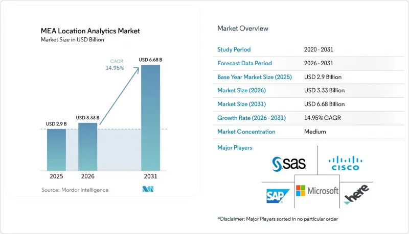
Mordor Intelligence에 의하면, 2026년 중동 및 아프리카의 위치 분석 시장 규모는 33억 3,000만 달러로 추정되며, 2025년 29억 달러에서 2031년에는 66억 8,000만 달러에 달할 것으로 예측됩니다.
또한 2026-2031년 연평균 성장률(CAGR) 14.95%를 기록할 전망입니다.
본 보고서는 위치별(실외, 실내), 도입 모델별(On-Premise, 온디맨드(클라우드)), 용도별(원격 모니터링, 자산 관리, 시설 관리), 구성 요소별(소프트웨어 및 서비스), 산업별(소매, 제조 등) 및 국가별로 분류되어 있습니다. 시장 전망은 금액(달러) 기준으로 제시됩니다.
중동 및 아프리카 지역의 위치 분석 시장 동향 및 인사이트
GCC의 스마트 시티 프로그램에서 IoT 센서의 보급
리야드, 두바이, 도하에 광범위하게 구축된 센서 네트워크는 지속적인 지오태그 데이터 스트림을 생성하고 있으며, 이를 처리하기 위해서는 실시간 수집 및 시각화가 가능한 강력한 분석 플랫폼이 필요합니다. 두바이에서는 200개 이상의 스마트 서비스가 도입되어 있으며, 메카에서는 하즈 시즌 동안 산악 지대에서도 연결성을 유지하기 위해 LoRa 지원 기기의 도입이 진행되고 있습니다. 지방 자치 단체는 이러한 데이터 스트림을 활용하여 교통량 예측, 쓰레기 수거 최적화, 공공 안전 관련 사안 모니터링을 수행하고 있습니다. 그 결과 발생하는 방대한 데이터 양으로 인해 도시 당국은 정보 원천에서 데이터를 필터링 및 분석하고 의사 결정을 가속화하는 엣지 처리 및 AI 알고리즘 도입을 서둘러야 하는 상황에 놓여 있습니다. 시범 도입이 본격 운영으로 전환됨에 따라, 지자체 입찰 요건에는 오픈 API 및 멀티 프로토콜 지원이 점점 더 명시되고 있어 공급업체 생태계의 확장이 촉진되고 있습니다.
5G 스몰셀의 확산 가속화로 실시간 분석 가능
GCC 국가 수도들의 광범위한 5G 커버리지 덕분에 10밀리초 미만의 지연 시간이 실현되어, 자율 주행 셔틀, 드론을 활용한 점검, 증강현실(AR)을 활용한 길 안내와 같은 첨단 용도이 가능해졌습니다. 통신 사업자들은 지자체 기획 담당자와 협력하여 도로 시설에 스몰 셀을 통합하고 있으며, 이를 통해 신호 밀도가 향상되어 고해상도 추적 및 영상 분석이 가능해졌습니다. 새로운 대역폭 덕분에 고해상도 3D 지도를 관제실로 실시간 스트리밍할 수 있게 되어, 긴급 대응 협력이 강화되고 있습니다. 석유, 유틸리티, 물류 등 각 업계의 기업들은 이동 자산에서 발생하는 데이터 흐름이 끊기지 않도록 해야 할 필요성을 이유로, 네트워크 업그레이드와 분석 로드맵을 연계하고 있습니다. 조기 도입 기업들에서는 엣지 AI가 센서 경보를 로컬에서 처리함으로써, 예측 유지보수를 통해 운영 비용을 절감하는 효과가 보고되고 있습니다.
데이터 주권 및 개인정보 보호 규정
사우디아라비아의 ‘개인 데이터 보호법’ 및 UAE의 ‘데이터 보호에 관한 연방 법령’은 처리 사업자에게 기밀성이 높은 위치 정보를 국내에 저장할 것을 의무화하고 있습니다. 의료, 금융, 국방 관련 프로젝트에서는 엄격한 동의 획득 및 감사 추적 요건이 부과되고 있어, On-Premise 또는 주권형 클라우드로의 도입이 진행되고 있습니다. 이에 대응하여 다국적 벤더들은 현지 클라우드 리전을 구축하고, 개인을 식별할 수 있는 정보를 분리하는 데이터 로컬라이제이션 계층을 제공함으로써 대응하고 있습니다. 규정 준수 점검으로 인해 프로젝트 일정과 비용이 증가하며, 대부분의 경우 법적 검토, 암호화 키 관리 및 현지 사고 대응 프로토콜이 필요합니다.
부문 분석
2025년, 교통부 및 유틸리티부가 고속도로, 항만, 지하철 시스템의 디지털화를 추진한 결과, 실외 솔루션은 중동 및 아프리카 지역의 위치 정보 분석 시장의 71.35%를 차지했습니다. 카메라 영상과 지오펜싱 알고리즘을 결합함으로써 동적 요금 징수 및 신호 제어 최적화가 실현되어 주요 간선 도로의 교통 체증이 완화되었습니다. 중동 및 아프리카 지역의 실외 전개에 있어 위치 정보 분석 시장 규모는 도시 전역을 아우르는 모빌리티 애즈 어 서비스(MaaS) 플랫폼의 보급에 힘입어 2031년까지 꾸준히 확대될 것으로 예측됩니다. 실내에서는 쇼핑몰, 공항, 병원 등이 비콘이나 LiDAR를 도입하여 고객의 이동 경로 및 자산 이용 현황에 대한 인사이트력을 얻고 있습니다. 도입이 가장 많이 진행되고 있는 곳은 일류 쇼핑몰이며, 이곳에서는 운영상의 이점이 하드웨어 및 보정 비용을 상회하고 있습니다. 근거리 추적 기술은 매장 앱과 로열티 프로그램 간의 격차를 해소하고 캠페인 전환율을 향상시킵니다.
새로운 이용 사례에서는 실내 및 실외 데이터 세트를 융합하여 신호 단절 없이 공급망의 각 거점에 걸쳐 자산을 추적하고 있습니다. 물류 사업자는 크로스독 창고와 라스트 마일 경로를 단일 플랫폼 상에서 매핑함으로써 인계 정확도를 높이고 분실 사고를 줄이고 있습니다. 시설 관리자는 빌딩 정보 모델링(BIM)과 GIS 대시보드를 통합하여 공간적 맥락에서 유지보수 요청을 시각화하고 있습니다. 이러한 융합으로 인해 평면도 디지털화, Wi-Fi 히트맵 및 전지구위성항법시스템(GNSS) 보정 서비스를 통합한 솔루션을 제공하는 새로운 벤더들이 시장에 진입하고 있으며, 중동 및 아프리카(중동 및 아프리카) 지역의 위치 분석 산업 전반에 걸쳐 두 자릿수 성장이 예상됩니다.
클라우드 플랫폼은 2025년에 중동 및 아프리카의 위치 분석 시장의 65.40%를 차지하며, 연평균 성장률(CAGR) 19.18%로 On-Premise 시스템을 계속해서 앞지르고 있습니다. 통신 사업자, 소매업체, 공공 기관은 하이퍼스케일러가 운영하는 지역 데이터센터를 활용하여 테라바이트 규모의 지리 공간 레코드를 탄력적으로 저장 및 처리하고 있습니다. 데이터 주권을 준수하는 지역이 늘어남에 따라, 클라우드 호스팅형 워크로드의 중동 및 아프리카의 위치 분석 시장 규모는 2027년까지 On-Premise 지출을 넘어설 것으로 예측됩니다. 지역 고유의 보안 인증 및 저지연 엣지 존 덕분에 자율 주행 셔틀 제어 및 실시간 군중 모니터링 등 지연에 민감한 용도의 이전이 촉진되고 있습니다.
기밀 프로젝트나 공공 네트워크에서 분리된 시설에서는 On-Premise형 솔루션이 여전히 필수적입니다. 국방 기관 및 중요 인프라 운영 사업자는 엄격한 성능 및 기밀 유지 요건을 충족하기 위해 내환경성 서버와 프라이빗 클라우드를 도입하고 있습니다. 하이브리드 아키텍처가 보급되면서, 스트리밍 데이터를 로컬에서 처리하는 엣지 어플라이언스를 통합하고, 집계된 분석 결과를 주권 클라우드에 오프로드하여 장기적인 분석을 수행하는 체계가 채택되고 있습니다. 각 벤더는 예산상의 제약을 완화하기 위해 사전 구축된 커넥터, 제로 트러스트 프레임워크, 종량제 과금 체계 등을 통해 차별화를 꾀하고 있으며, 중동 및 아프리카 지역의 위치 분석 업계에서 도입의 유연성이 구매 결정의 기반이 되고 있음이 드러났습니다.
기타 혜택:
- 엑셀 형식 시장 예측(ME) 시트
- 3개월간의 애널리스트 지원
자주 묻는 질문
목차
제1장 서론
제2장 조사 방법
제3장 주요 요약
제4장 시장 구도
제5장 시장 규모와 성장 예측
제6장 경쟁 구도
제7장 시장 기회와 향후 전망
LSH 26.09.10According to Mordor Intelligence, the MEA location analytics market size in 2026 is estimated at USD 3.33 billion, growing from 2025 value of USD 2.9 billion with 2031 projections showing USD 6.68 billion, growing at 14.95% CAGR over 2026-2031.
This report is Segmented by Location (Outdoor, Indoor), Deployment Model (On-Premise, On-Demand (Cloud)), Application (Remote Monitoring, Asset Management, and Facility Management), Component (Software and Services), Vertical (Retail, Manufacturing, and More), and by Country. The Market Forecasts are Provided in Terms of Value (USD).
MEA Location Analytics Market Trends and Insights
Proliferation of IoT Sensors in GCC Smart-City Programmes
Ubiquitous sensor networks in Riyadh, Dubai, and Doha generate continuous geotagged streams that demand powerful analytics platforms capable of real-time ingestion and visualization. Dubai has implemented more than 200 smart services, while Makkah is integrating LoRa-enabled devices to maintain connectivity in mountainous terrain during the Hajj season. Municipal agencies use these data flows to predict traffic density, optimize waste collection, and monitor public safety incidents. The resulting data volume pushes city authorities to adopt edge processing and AI algorithms that filter and analyze information at the source, accelerating decision-making. As pilot deployments shift to full production, municipal tenders increasingly specify open APIs and multi-protocol compatibility, encouraging a broader supplier ecosystem.
Accelerated 5G Small-Cell Rollout Enabling Real-Time Analytics
Widespread 5G coverage in GCC capitals delivers sub-10-millisecond latency, allowing advanced applications such as autonomous shuttles, drone-based inspection, and augmented-reality wayfinding. Operators collaborate with municipal planners to embed small cells in street furniture, which improves signal density for high-resolution tracking and video analytics. The new bandwidth permits live streaming of high-definition 3D maps to control rooms, enhancing emergency response coordination. Enterprises across oil, utilities, and logistics verticals are aligning network upgrades with analytics roadmaps, citing the need for uninterrupted data flows from mobile assets. Early adopters report operational cost savings from predictive maintenance once edge AI processes sensor alerts locally.
Data-Sovereignty and Privacy Regulations
Saudi Arabia's Personal Data Protection Law and the UAE's Federal Decree-Law on Data Protection oblige processors to store sensitive location attributes within national borders. Healthcare, finance, and defense projects face strict consent and audit trails, prompting on-premises or sovereign cloud deployments. Multinational vendors respond by launching local cloud regions and offering data-localization tiers that segregate personally identifiable information. Compliance checks elevate project timelines and costs, often requiring legal reviews, encryption key management, and local incident-response protocols.
Other drivers and restraints analyzed in the detailed report include:
- Cloud-First GIS/BI Adoption Across Retail and Government
- Mandatory ESG Geo-Reporting for Large Energy Projects
- High CAPEX and Skills Gap for Indoor Positioning
For complete list of drivers and restraints, kindly check the Table Of Contents.
Segment Analysis
Outdoor solutions represented 71.35% of the MEA location analytics market in 2025 as ministries of transport and public works digitized highways, ports, and metro systems. Camera feeds combined with geofencing algorithms support dynamic tolling and traffic-signal optimization, cutting congestion on flagship corridors. The MEA location analytics market size for outdoor deployments is forecast to climb steadily through 2031, benefiting from city-wide mobility-as-a-service platforms. Indoors, malls, airports, and hospitals deploy beacons and LiDAR to gain customer-journey and asset-utilization insights. Uptake is strongest in tier-one malls where operational gains offset hardware and calibration costs. Near-field tracking bridges the gap between store apps and loyalty programs, enhancing campaign conversion.
Emerging use cases blend indoor and outdoor datasets to track assets across supply-chain nodes without signal drop. Logistics operators map cross-dock warehouses and final-mile routes on a single platform, improving hand-off accuracy and reducing misplacement incidents. Facility managers integrate building information modeling with GIS dashboards to visualize maintenance tickets in spatial context. This convergence draws new vendors that bundle floor-plan digitization, Wi-Fi heat-mapping, and global navigation satellite system (GNSS) correction services into unified offerings, positioning them for double-digit gains within the broader MEA location analytics industry.
Cloud platforms owned 65.40% of the MEA location analytics market in 2025 and continue to outpace on-premises systems with a 19.18% CAGR. Telecom operators, retailers, and public agencies rely on regional data centers operated by hyperscalers to elastically store and process terabytes of geospatial records. The MEA location analytics market size for cloud-hosted workloads is projected to surpass on-premises spending before 2027 as data-sovereignty-compliant regions multiply. Region-specific security certifications and low-latency edge zones encourage migration of latency-sensitive applications such as autonomous shuttle control and real-time crowd monitoring.
On-premises solutions remain essential for classified projects and installations disconnected from public networks. Defense and critical-infrastructure operators deploy ruggedized servers and private clouds to meet stringent performance and confidentiality targets. Hybrid architectures gain traction, integrating edge appliances that process streaming data locally before offloading aggregated insights to sovereign clouds for long-term analytics. Vendors differentiate through pre-built connectors, zero-trust frameworks, and pay-as-you-go pricing to ease budget constraints, illustrating how deployment flexibility underpins purchasing decisions across the MEA location analytics industry.
Complete Report Scope:
- By Location
- Outdoor
- Indoor
- By Deployment Model
- On-premise
- On-demand (Cloud)
- By Application
- Remote Monitoring
- Asset Management
- Facility Management
- By Vertical
- Retail
- Manufacturing
- Healthcare
- Government
- Energy and Power
- Other Verticals
- By Component
- Software
- Services
- By Country
- United Arab Emirates
- Saudi Arabia
- Israel
List of Companies Covered in this Report:
- Cisco Systems
- Microsoft Corporation
- HERE Technologies
- SAS Institute Inc.
- Oracle Corporation
- SAP SE
- Esri
- Tibco Software Inc.
- Pitney Bowes
- Galigeo
- Hexagon AB
- TomTom
- Trimble Inc.
- Mapbox
- Alteryx
- CARTO
- Foursquare
- Splunk Inc.
- Ubisense
Additional Benefits:
- The market estimate (ME) sheet in Excel format
- 3 months of analyst support
TABLE OF CONTENTS
1 INTRODUCTION
- 1.1 Study Assumptions and Market Definition
- 1.2 Scope of the Study
2 RESEARCH METHODOLOGY
3 EXECUTIVE SUMMARY
4 MARKET LANDSCAPE
- 4.1 Market Overview
- 4.2 Market Drivers
- 4.2.1 Proliferation of IoT sensors in GCC smart-city programmes
- 4.2.2 Accelerated 5G small-cell rollout enabling real-time analytics
- 4.2.3 Cloud-first GIS/BI adoption across retail and government
- 4.2.4 Mandatory ESG geo-reporting for large energy projects
- 4.3 Market Restraints
- 4.3.1 Data-sovereignty and privacy regulations
- 4.3.2 High CAPEX and skills gap for indoor positioning
- 4.4 Value / Supply-Chain Analysis
- 4.5 Regulatory Landscape
- 4.6 Technological Outlook
- 4.7 Porters Five Forces
- 4.7.1 Bargaining Power of Suppliers
- 4.7.2 Bargaining Power of Buyers
- 4.7.3 Threat of New Entrants
- 4.7.4 Intensity of Competitive Rivalry
- 4.7.5 Threat of Substitutes
- 4.8 Investment Analysis
5 MARKET SIZE AND GROWTH FORECASTS (VALUE)
- 5.1 By Location
- 5.1.1 Outdoor
- 5.1.2 Indoor
- 5.2 By Deployment Model
- 5.2.1 On-premise
- 5.2.2 On-demand (Cloud)
- 5.3 By Application
- 5.3.1 Remote Monitoring
- 5.3.2 Asset Management
- 5.3.3 Facility Management
- 5.4 By Vertical
- 5.4.1 Retail
- 5.4.2 Manufacturing
- 5.4.3 Healthcare
- 5.4.4 Government
- 5.4.5 Energy and Power
- 5.4.6 Other Verticals
- 5.5 By Component
- 5.5.1 Software
- 5.5.2 Services
- 5.6 By Country
- 5.6.1 United Arab Emirates
- 5.6.2 Saudi Arabia
- 5.6.3 Israel
6 COMPETITIVE LANDSCAPE
- 6.1 Market Concentration
- 6.2 Strategic Moves
- 6.3 Market Share Analysis
- 6.4 Company Profiles (includes Global level Overview, Market level overview, Core Segments, Financials as available, Strategic Information, Market Rank/Share for key companies, Products and Services, and Recent Developments)
- 6.4.1 Cisco Systems
- 6.4.2 Microsoft Corporation
- 6.4.3 HERE Technologies
- 6.4.4 SAS Institute Inc.
- 6.4.5 Oracle Corporation
- 6.4.6 SAP SE
- 6.4.7 Esri
- 6.4.8 Tibco Software Inc.
- 6.4.9 Pitney Bowes
- 6.4.10 Galigeo
- 6.4.11 Hexagon AB
- 6.4.12 TomTom
- 6.4.13 Trimble Inc.
- 6.4.14 Mapbox
- 6.4.15 Alteryx
- 6.4.16 CARTO
- 6.4.17 Foursquare
- 6.4.18 Splunk Inc.
- 6.4.19 Ubisense
7 MARKET OPPORTUNITIES AND FUTURE OUTLOOK
- 7.1 White-space and Unmet-Need Assessment


